Publication Plan April 2024
(8) Appendix C
Housing allocation maps and proformas
Tier 1
Bilbrook & Codsall

|
Site reference |
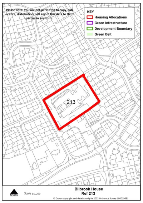
213 |
Village |
Bilbrook |
|
Minimum capacity |
13 dwellings |
Address |
Bilbrook House |
|
Site area |
0.5 ha |
Proposed use |
Housing |
|
|
|||
|
Key requirements |
Any relevant policy requirements including affordable housing, open space, education, health, sports and recreation, energy efficiency, climate change mitigation, flood risk mitigation, highways, sustainable transport, housing mix and green infrastructure, delivered in line with the relevant development plan policy standards. |
||
|
Proposed access/active travel measures |
Provide vehicular and pedestrian access via Carter Avenue |
||
|
Site reference |
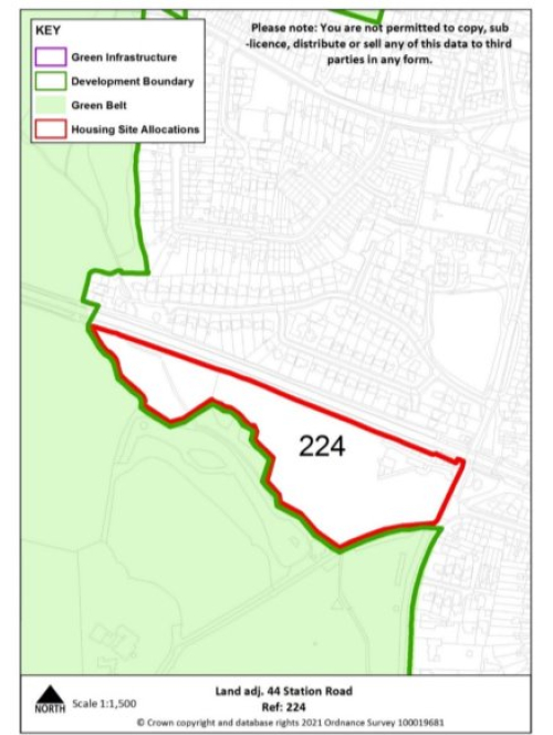
224 |
Village |
Codsall |
|
Minimum capacity |
85 dwellings |
Address |
Land adjacent to Station Road |
|
Site area |
4 ha |
Proposed use |
Housing |
|
|
|||
|
Key requirements |
|
||
|
Proposed access/active travel measures |
Provide vehicular and pedestrian access via Station Road |
||
|
Site reference |
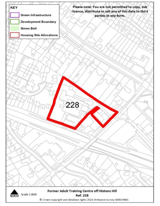
228 |
Village |
Codsall |
|
Minimum capacity |
29 dwellings |
Address |
Former Adult Training Centre off Histons Hill |
|
Site area |
0.8 ha |
Proposed use |
Housing |
|
|
|||
|
Key requirements |
Any relevant policy requirements including affordable housing, open space, education, health, sports and recreation, energy efficiency, climate change mitigation, flood risk mitigation, highways, sustainable transport, housing mix and green infrastructure, delivered in line with the relevant development plan policy standards. |
||
|
Proposed access/active travel measures |
Provide vehicular and pedestrian access via Histons Hill |
||
|
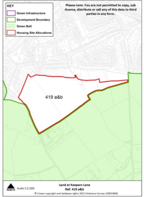
Site reference |
419 a&b |
Village |
Codsall |
|
Minimum capacity |
317 dwellings |
Address |
Land at Keepers Lane & Wergs Hall Rd |
|
Site area |
15.1 ha |
Proposed use |
Housing |
|
|
|||
|
Key requirements |
|
||
|
Proposed access/active travel measures |
Provide vehicular and pedestrian access via Wergs Hall Road and into the adjacent allocated housing site, including provision of a through road from Keepers Lane to Wergs Hall Road and extension of existing footway. |
||
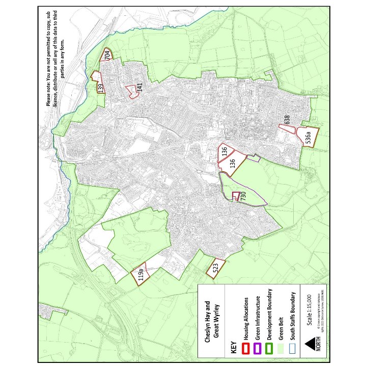
Cheslyn Hay & Great Wyrley
|
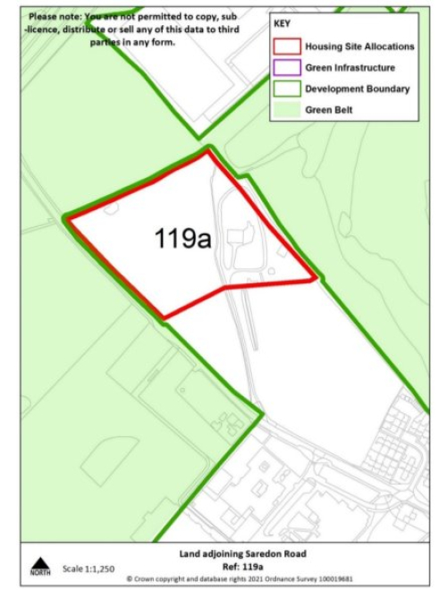
Site reference |
119a |
Village |
Cheslyn Hay |
|
Minimum capacity |
60 |
Address |
Land adjoining Saredon Road |
|
Site area |
2.9 ha |
Proposed use |
Housing |
|
|
|||
|
Key requirements |
|
||
|
Proposed access/active travel measures |
Provide vehicular, walking, wheeling and cycle access onto Saredon Road, including extension of footway and contribute to Staffordshire County Council's Local Walking and Cycling Infrastructure Plan (LCWIP) for Cheslyn Hay/Great Wyrley. Dropped crossing and tactile paving should be provided at all side roads on all routes directly accessing the development. |
||
|
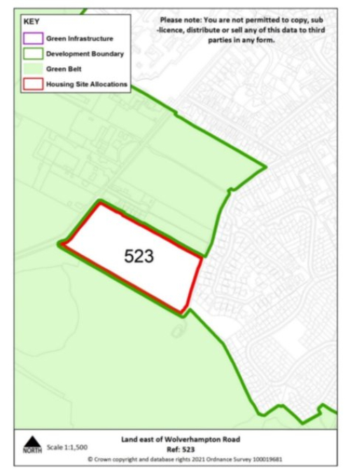
Site reference |
523 |
Village |
Cheslyn Hay |
|
Minimum capacity |
49 |
Address |
Land east of Wolverhampton Road |
|
Site area |
2.4 ha |
Proposed use |
Housing |
|
|
|||
|
Key requirements |
|
||
|
Proposed access/active travel measures |
Provide vehicular, walking, wheeling and cycling access onto Wolverhampton Road, and contribute to Staffordshire County Council's Local Walking and Cycling Infrastructure Plan (LCWIP) for Cheslyn Hay/Great Wyrley. Additionally, walking and cycling access to Pinfold Lane should be explored. Dropped crossing and tactile paving should be provided at all side roads on all routes directly accessing the development. |
||
|
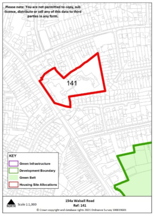
Site reference |
141 |
Village |
Great Wyrley |
|
Minimum capacity |
31 dwellings |
Address |
154a Walsall Road |
|
Site area |
1.2 ha |
Proposed use |
Housing |
|
|
|||
|
Key infrastructure requirements |
|
||
|
Proposed access/active travel measures |
Provide vehicular and pedestrian access via Walsall Road. |
||
|
Site reference |
136 |
Village |
Great Wyrley |
|
Minimum capacity |
50 dwellings consented on allocated site (21/00631/FUL) alongside minimum 109 dwellings on safeguarded land |
Address |
Land at Landywood Lane |
|
Site area |
7.4 ha |
Proposed use |
Housing |
|
|
|||
|
Key infrastructure requirements |
|
||
|
Proposed access/active travel measures |
Provide vehicular and pedestrian access via Landywood Lane and Upper Landywood Lane, alongside pedestrian access into new country park. Walking, wheeling and cycling access onto Landywood Lane should be provided to contribute to active travel improvements along Landywood Lane. |
||
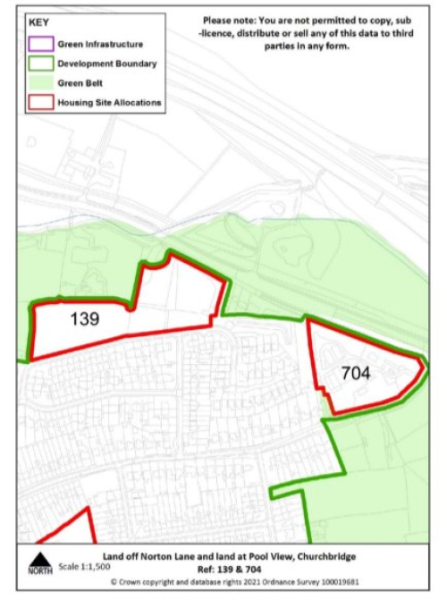
|
Site reference |
139 |
Village |
Great Wyrley |
|
Minimum capacity |
46 dwellings |
Address |
Pool View, Churchbridge |
|
Site area |
2.2 ha |
Proposed use |
Housing |
|
|
|||
|
Key infrastructure requirements |
|
||
|
Proposed access/active travel measures |
Provide vehicular and pedestrian access via Pool View. |
||
|
Site Reference |
704 |
Village |
Great Wyrley |
|
Minimum capacity |
31 dwellings |
Address |
Land off Norton Lane |
|
Site area |
1.3 ha |
Proposed Use |
Housing |
|
|
|||
|
Key requirements |
|
||
|
Proposed access |
Provide vehicular and pedestrian access via Norton Lane, including pedestrian crossing. |
||
|
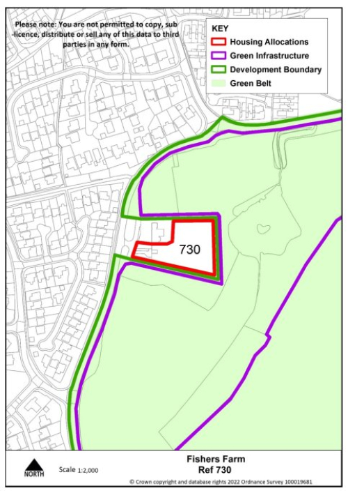
Site Reference |
730 |
Village |
Great Wyrley |
|
Minimum capacity |
10 dwellings |
Address |
Fishers Farm |
|
Site area |
0.3 ha |
Proposed Use |
Housing |
|
|
|||
|
Key requirements |
|
||
|
Proposed access/active travel measures |
Provide vehicular and pedestrian access via Upper Landywood Lane. |
||
|
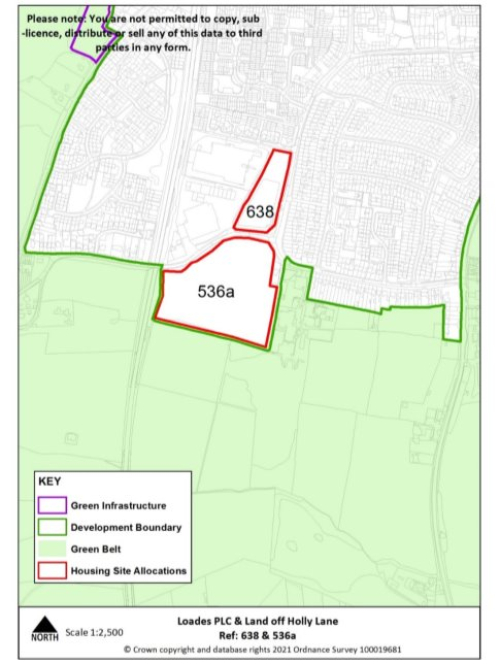
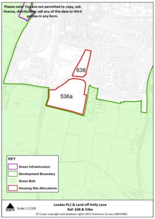
Site Reference |
536a |
Village |
Great Wyrley |
|
Minimum capacity |
84 dwellings |
Address |
Land off Holly Lane |
|
Site area |
4 ha |
Proposed Use |
Housing |
|
|
|||
|
Key requirements |
|
||
|
Proposed access/active travel measures |
Provide vehicular and pedestrian access via Holly Lane. |
||
|
Site Reference |
638 |
Village |
Great Wyrley |
|
Minimum capacity |
29 dwellings |
Address |
Loades Plc |
|
Site area |
1.1ha |
Proposed Use |
Housing |
|
|
|||
|
Key requirements |
|
||
|
Proposed access/active travel measures |
Provide vehicular and pedestrian access via Gorsey Lane |
||
Penkridge
|
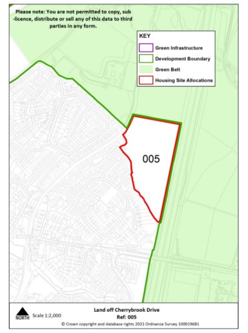
Site reference |
005 |
Village |
Penkridge |
|
Minimum capacity |
88 dwellings |
Address |
Land at Cherrybrook |
|
Site area |
4.2 ha |
Proposed use |
Housing |
|
|
|||
|
Key requirements |
|
||
|
Proposed access/active travel measures |
Provide, vehicle walking, wheeling and cycling access onto Cannock Road, through the existing Cherrybrook estate, and contribute towards Staffordshire County Council's proposed walking, wheeling and cycling improvements along Cannock Road. |
||
|
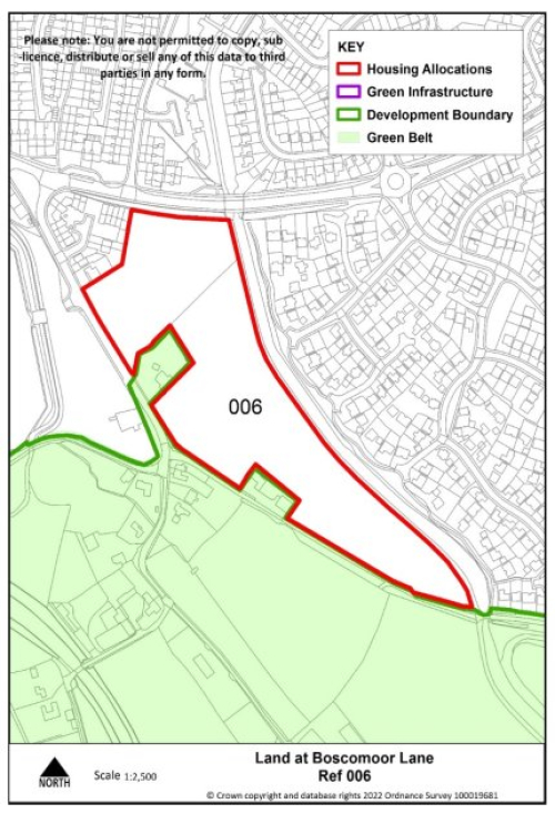
Site reference |
006 |
Village |
Penkridge |
|
Minimum capacity |
80 dwellings |
Address |
Land at Boscomoor Lane |
|
Site area |
3.8ha |
Proposed use |
Housing |
|
|
|||
|
Key requirements |
|
||
|
Proposed access/active travel measures |
Provide vehicular and pedestrian access via Boscomoor Lane ensuring continuous pedestrian links between the site and Wolgarston Way and active travel links onto the canal towpath along the eastern edge of the site, as well as improvements to the canal towpath surface. |
||
Tier 2
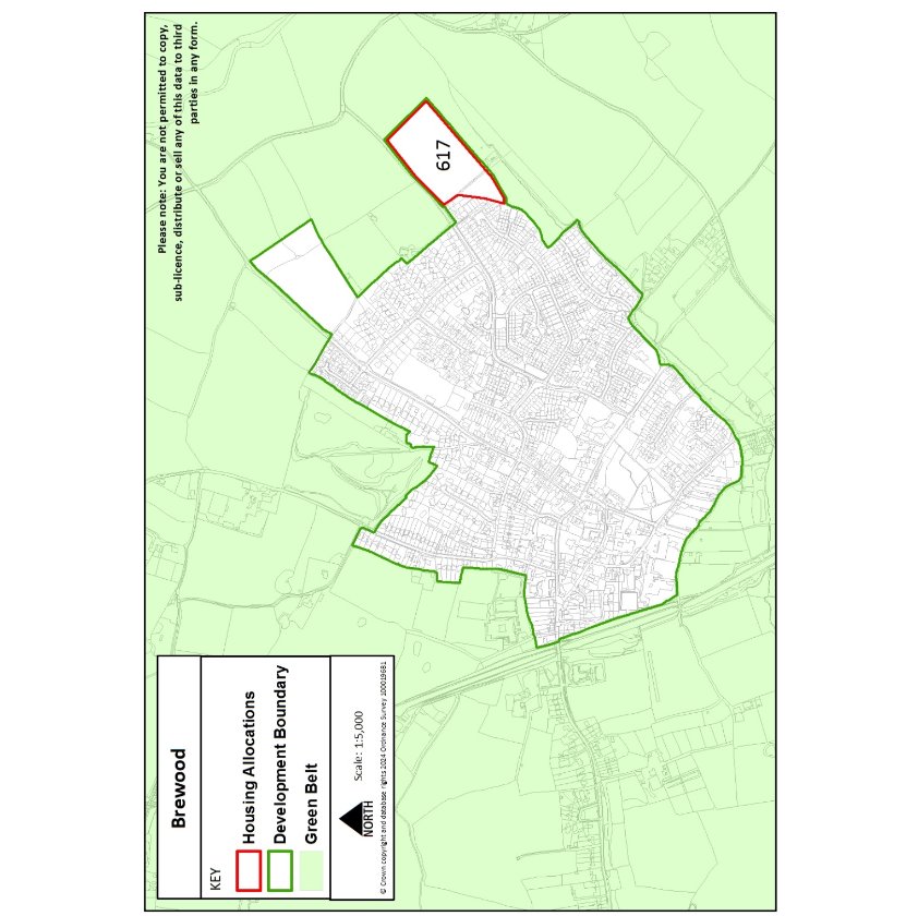
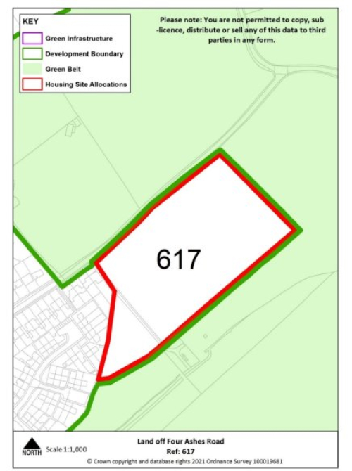
Brewood
|
Site reference |
617 |
Village |
Brewood |
|
Minimum capacity |
63 dwellings |
Address |
Land at Four Ashes Road |
|
Site area |
3 ha |
Proposed use |
Housing |
|
|
|||
|
Key requirements |
|
||
|
Proposed access/active travel measures |
Provide vehicular and pedestrian access via Four Ashes Road including extension of existing footway. Walking, wheeling and cycling access through to Stonebridge Road should be explored and provided if feasible. |
||
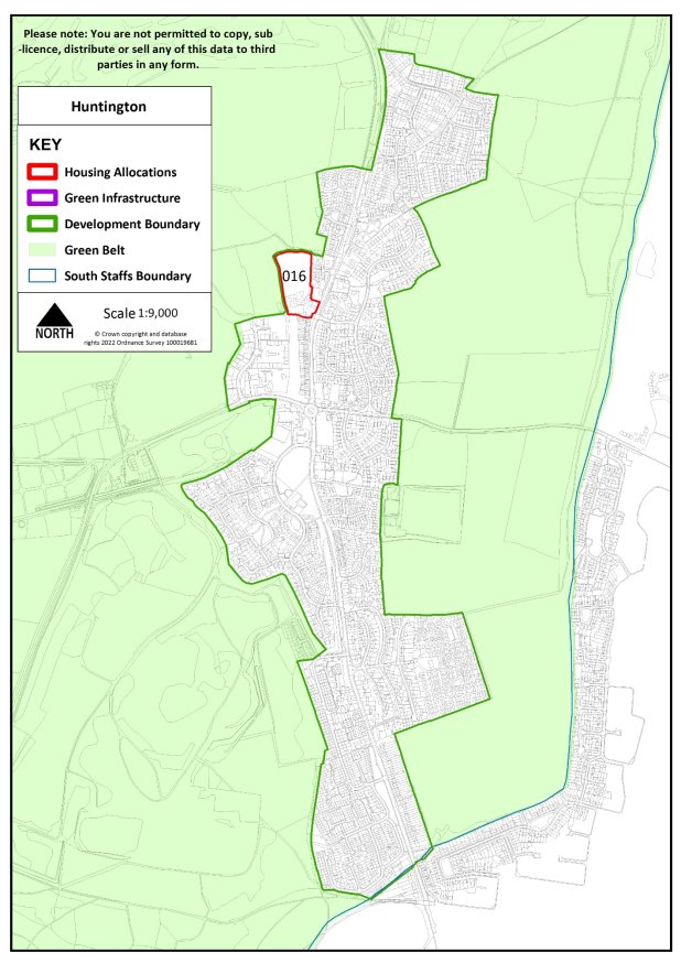
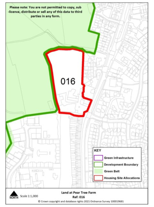
Huntington
|
Site Reference |
016 |
Village |
Huntington |
|
Minimum capacity |
39 |
Address |
Land at Pear Tree Farm |
|
Site area |
1.6 ha |
Proposed Use |
Housing |
|
|
|||
|
Key requirements |
|
||
|
Proposed access/active travel measures |
Provide vehicular, walking, wheeling and cycling access onto and across A34 Stafford Road, and contribute towards Staffordshire County Council's proposed walking, wheeling and cycling improvements along A34 Stafford Road. |
||
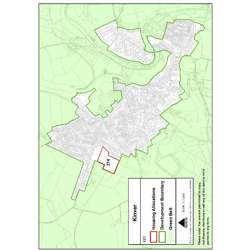
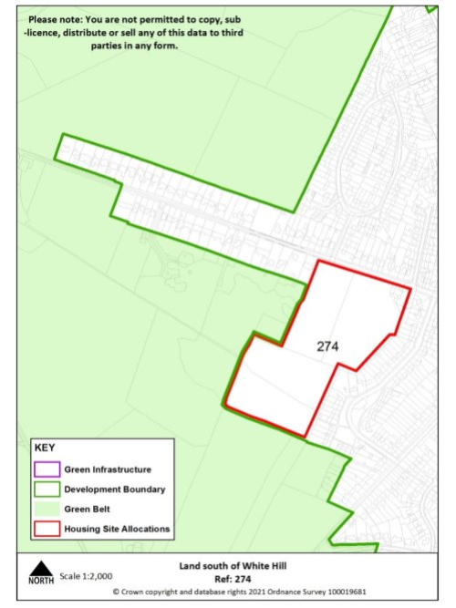
Kinver
|
Site reference |
274 |
Village |
Kinver |
|
Minimum capacity |
38 dwellings consented on allocated site (20/00621/OUT) alongside minimum 82 dwellings on safeguarded land |
Address |
Land south of White Hill |
|
Site area |
5.5 ha |
Proposed use |
Housing |
|
|
|||
|
Key requirements |
|
||
|
Proposed access/active Travel measures |
Provide vehicular and pedestrian access via White Hill. |
||
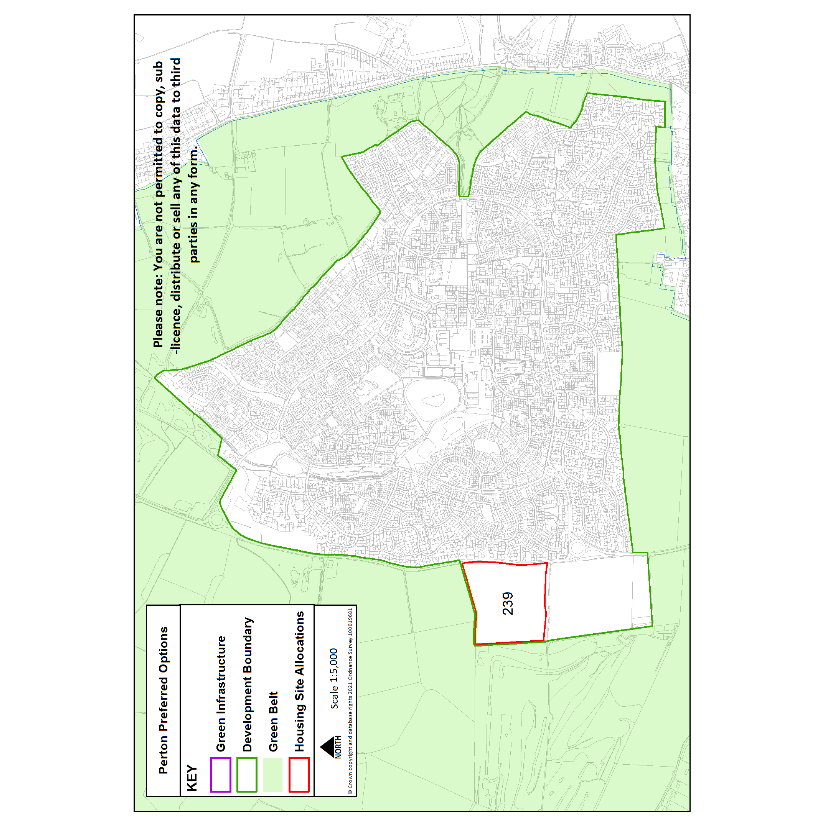
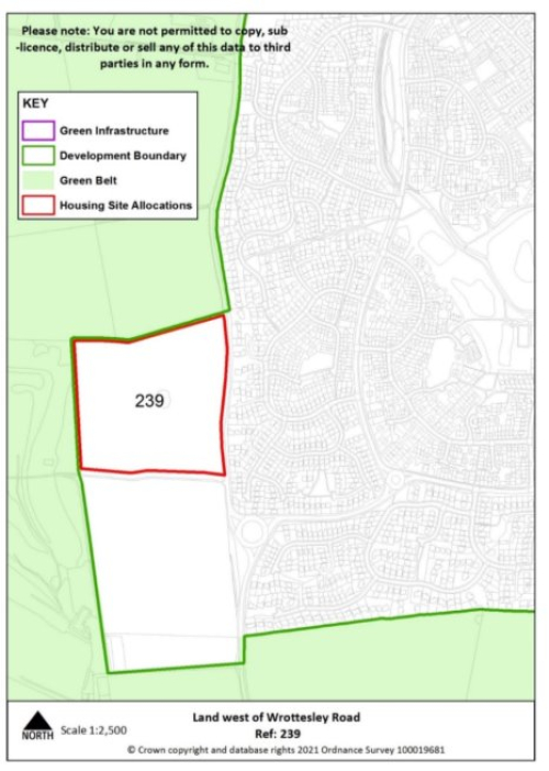
Perton
|
Site reference |
239 |
Village |
Perton |
|
Minimum capacity |
150 dwellings |
Address |
Land west of Wrottesley Park Road (south) |
|
Site area |
7.2 ha |
Proposed use |
Housing |
|
|
|||
|
Key requirements |
|
||
|
Proposed access/active travel measures |
Provide vehicular and pedestrian access via Wrottesley Park Road and pedestrian access into neighbouring allocated site. |
||
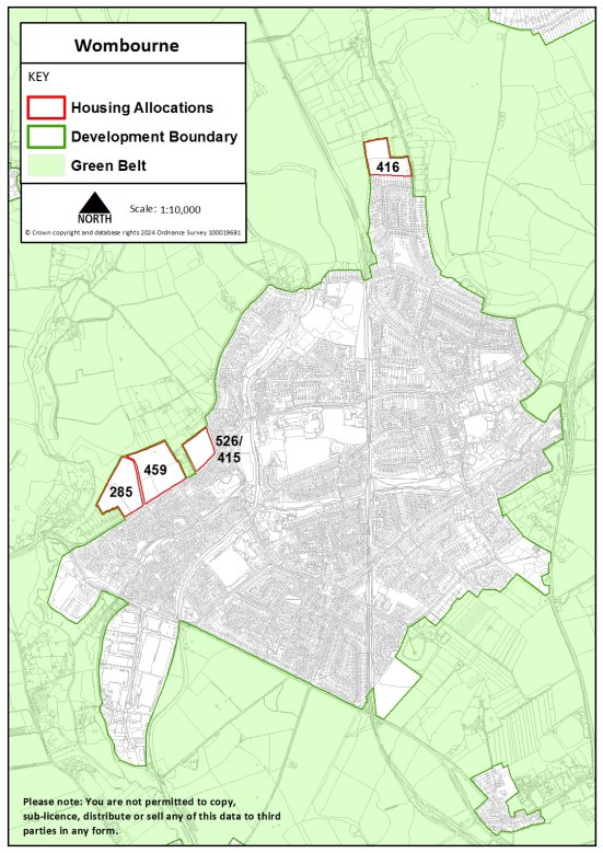
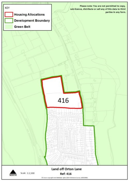
Wombourne
|
Site Reference |
416 |
Village |
Wombourne |
|
Minimum capacity |
57 dwellings |
Address |
Land off Orton Lane |
|
Site area |
2.8ha |
Proposed Use |
Housing |
|
|
|||
|
Key requirements |
|
||
|
Proposed access/active travel measures |
Provide vehicular and pedestrian access via Orton Lane, including extension of existing footway. |
||
|
Site Reference |
285 |
Village |
Wombourne |
|
Minimum capacity |
82 dwellings |
Address |
Land off Pool House Road |
|
Site area |
3.9ha |
Proposed Use |
Housing |
|
|
|||
|
Key requirements |
|
||
|
Proposed access/active travel measures |
Provide vehicular access via Pool House Road. Provide walking, wheeling and cycling access onto and across Pool House Road, and contribute towards Staffordshire County Council's proposed walking, wheeling and cycling improvements along Pool House Road and Ounsdale Road which will link this area to Wombourne village centre. |
||
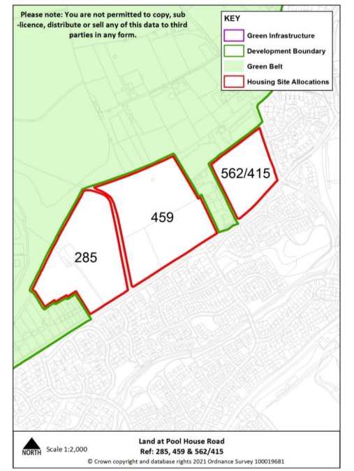
|
Site Reference |
562/415 |
Village |
Wombourne |
|
Minimum capacity |
44 dwellings |
Address |
Land off Pool House Road |
|
Site area |
1.9ha |
Proposed Use |
Housing |
|
|
|||
|
Key requirements |
|
||
|
Proposed access/active travel measures |
Provide vehicular access via Pool House Road. Provide walking, wheeling and cycling access onto and across Pool House Road, and contribute towards Staffordshire County Council's proposed walking, wheeling and cycling improvements along Pool House Road and Ounsdale Road which will link this area to Wombourne village centre. |
||
|
Site Reference |
459 |
Village |
Wombourne |
|
Minimum capacity |
97 dwellings |
Address |
Land off Pool House Road |
|
Site area |
4.6ha |
Proposed Use |
Housing |
|
|
|||
|
Key requirements |
|
||
|
Proposed access/active travel measures |
Provide vehicular access via Pool House Road. Provide walking, wheeling and cycling access onto and across Pool House Road, and contribute towards Staffordshire County Council's proposed walking, wheeling and cycling improvements along Pool House Road and Ounsdale Road which will link this area to Wombourne village centre. |
||
Tier 3
Coven
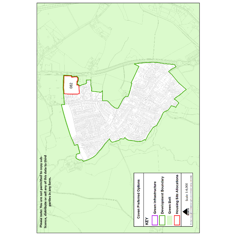
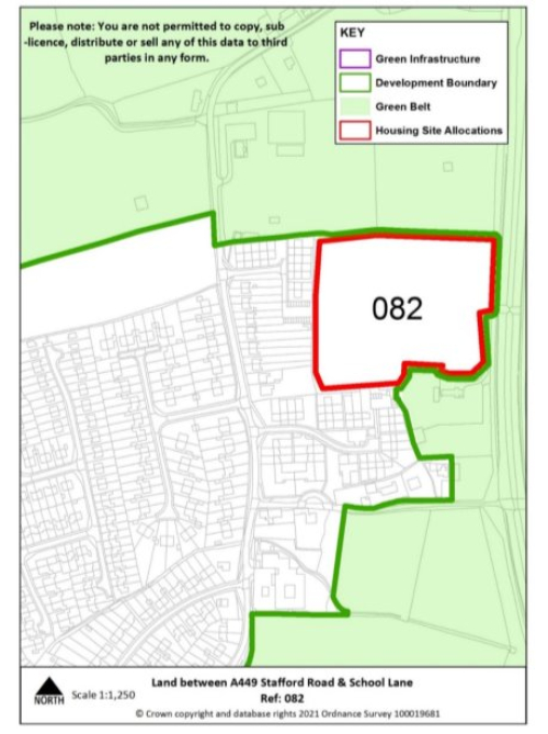
|
Site reference |
082 |
Village |
Coven |
|
Minimum capacity |
48 dwellings |
Address |
Land between A449 Stafford Road & School Lane |
|
Site area |
2.3 ha |
Proposed use |
Housing |
|
|
|||
|
Key infrastructure requirements |
|
||
|
Proposed access/active travel measures |
Provide vehicular and pedestrian access via the playing fields off School Lane. |
||
Featherstone
|
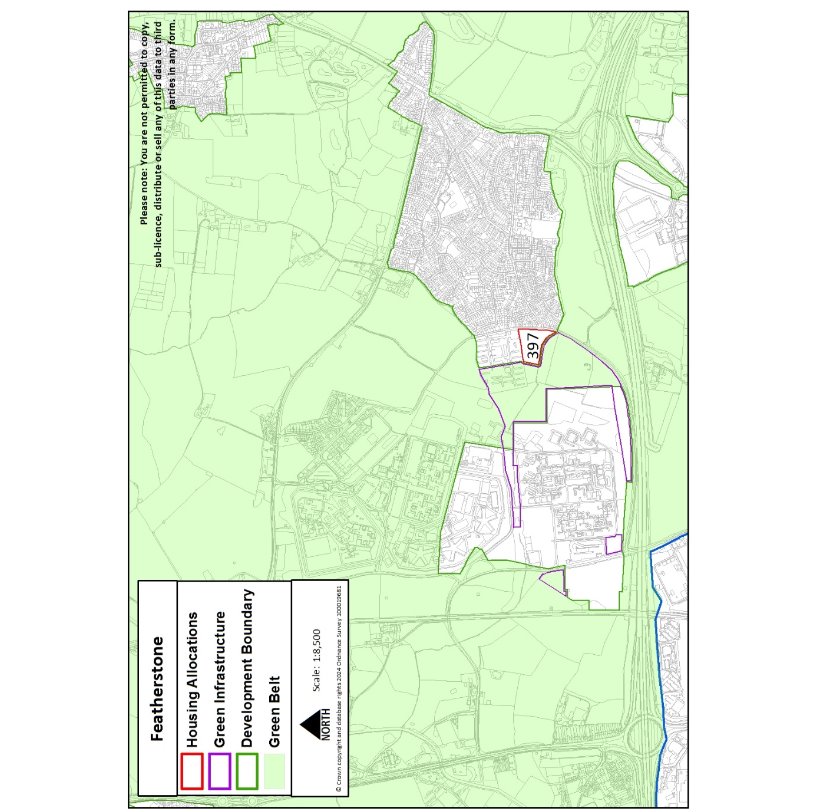
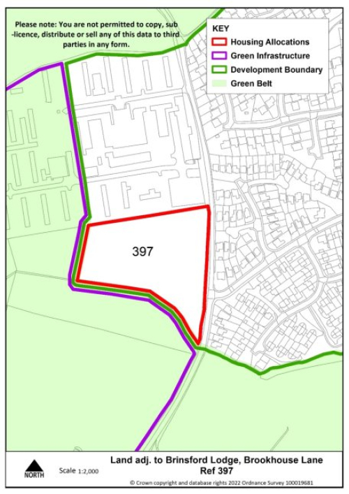
Site Reference |
397 |
Village |
Featherstone |
|
Minimum capacity |
35 dwellings |
Address |
Land adj. to Brookhouse Lane |
|
Site area |
1.6 ha |
Proposed Use |
Housing |
|
|
|||
|
Key requirements |
|
||
|
Proposed access/active travel measures |
Provide vehicular and pedestrian access via Malayan Way and into allocated site to the north. |
||
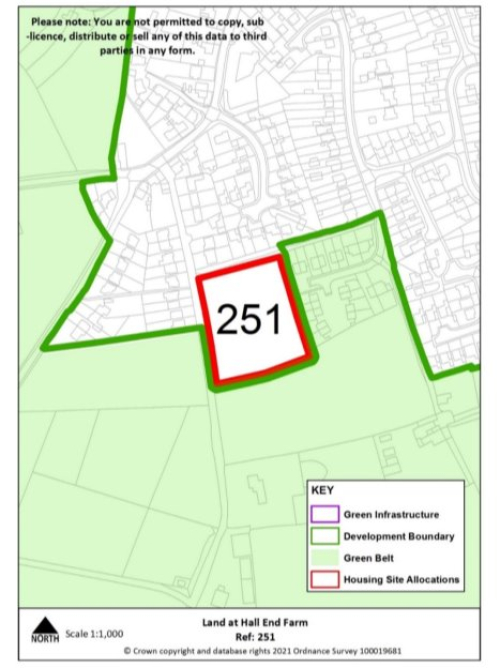
Pattingham
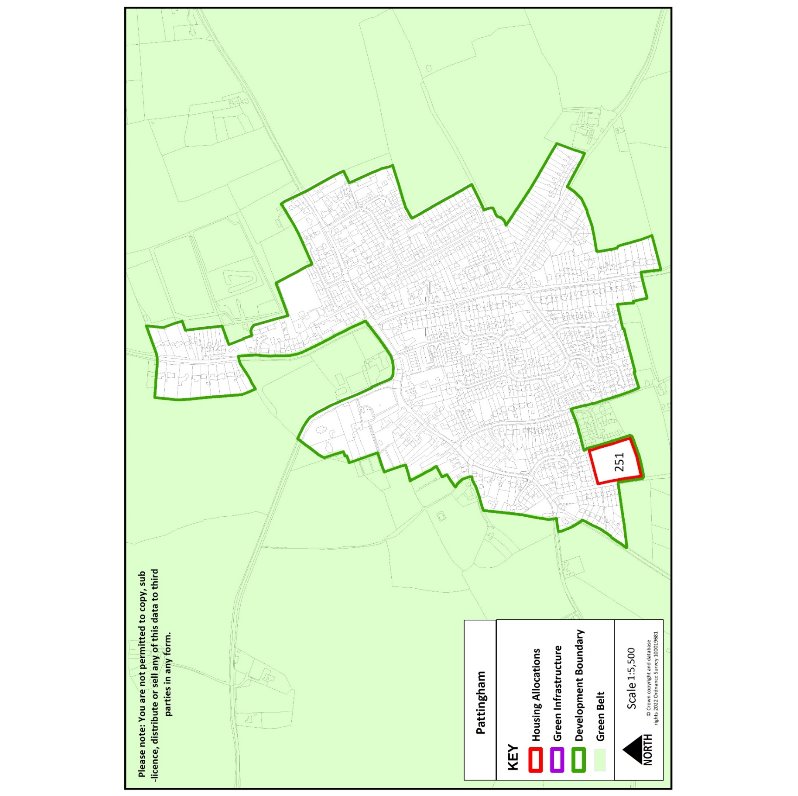
|
Site Reference |
251 |
Village |
Pattingham |
|
Minimum capacity |
17 dwellings |
Address |
Hall End Farm |
|
Site area |
0.8 ha |
Proposed Use |
Housing |
|
|
|||
|
Key requirements |
|
||
|
Proposed access |
Provide vehicular and pedestrian access to public highway via the adjacent rural exception site to the east |
||
Swindon
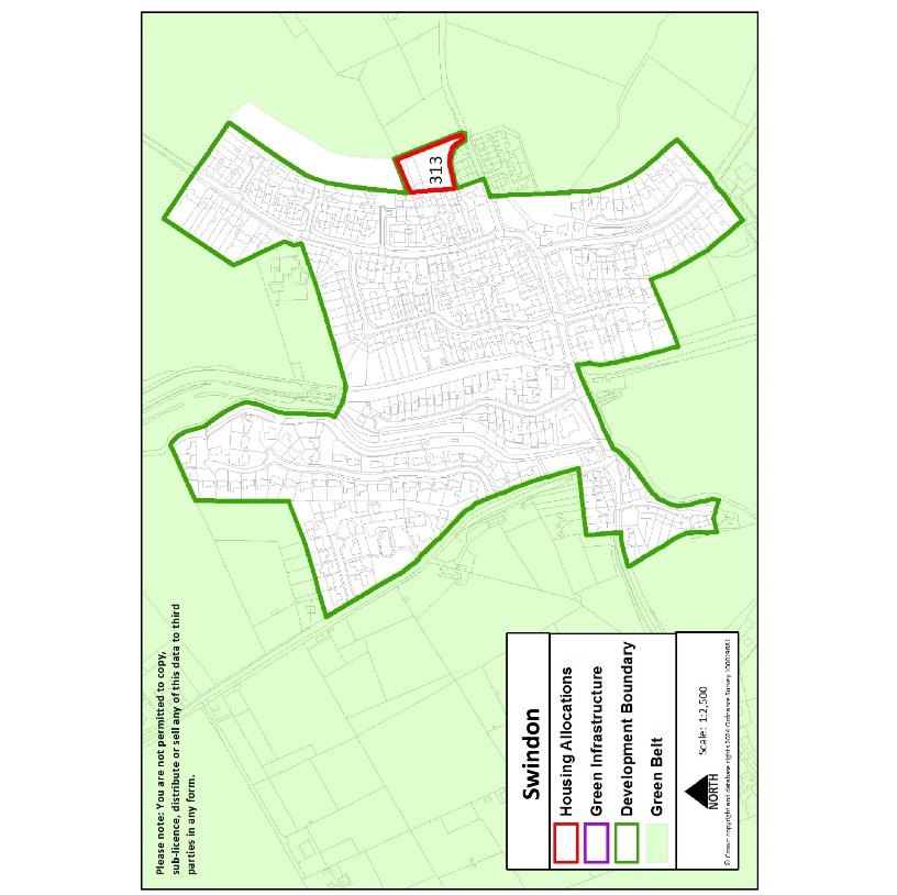
|
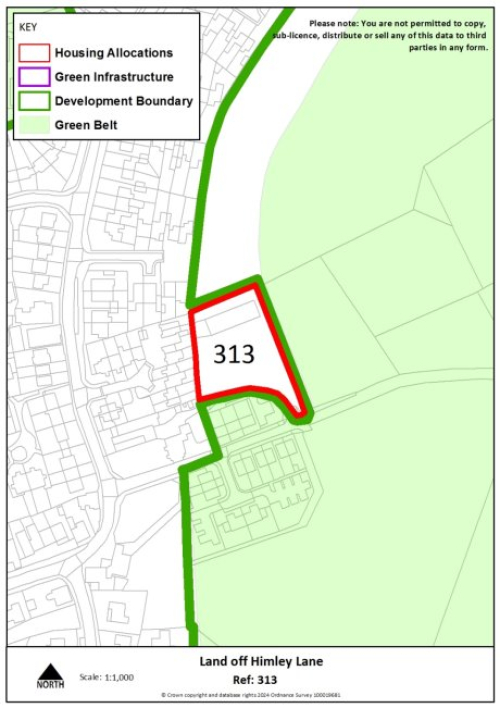
Site Reference |
313 |
Village |
Swindon |
|
Approximate capacity |
10 dwellings |
Address |
Land off Himley Lane |
|
Site area |
0.3ha |
Proposed Use |
Housing |
|
|
|||
|
Key requirements |
|
||
|
Proposed access/active travel measures |
Provide vehicular and pedestrian access via Himley Lane, including footway link to wider village. |
||
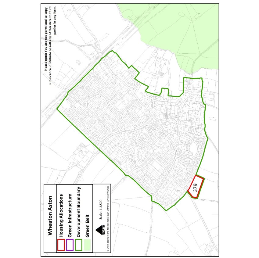
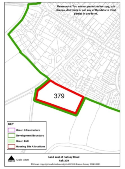
Wheaton Aston
|
Site reference |
379 |
Village |
Wheaton Aston |
|
Minimum capacity |
18 dwellings |
Address |
Land off Ivetsey Road |
|
Site area |
0.8 ha |
Proposed use |
Housing |
|
|
|||
|
Key requirements |
|
||
|
Proposed access/active travel measures |
Provide vehicular and pedestrian access via Ivetsey Road, including extension of existing footway. |
||
Urban Extensions to Neighbouring Towns
|
Site reference |
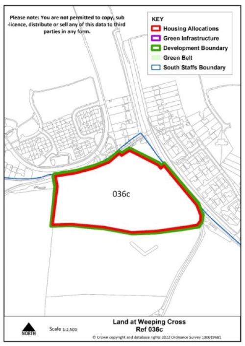
036c |
Village |
South of Stafford |
|
Minimum capacity |
81 dwellings |
Address |
Land at Weeping Cross (adjoining Stafford Borough boundary) |
|
Site area |
3.85 ha |
Proposed use |
Housing |
|
|
|||
|
Site requirements |
|
||
|
Proposed access/active travel measures |
Provide vehicular and pedestrian access via Cannock Road (A34) and deliver additional pedestrian and cycling links through to the existing Wildwood housing area. |
||