Publication Plan April 2024
5. Development Strategy
Green Belt
(8) 5.1 The distinctive character of South Staffordshire is directly influenced by the fact that approximately 80% of the district is Green Belt. This contributes to the district's rural character and helps distinguish the district from neighbouring urban areas such as the Black Country. Protecting the Green Belt from unplanned development as far as possible is therefore a key objective (Strategic Objective 1) of the Local Plan.
(2) 5.2 National Policy confirms that there is no requirement for Green Belt boundaries to be reviewed or changed when Local Plans are being prepared and that it is within authorities' gift to choose to review Green Belt boundaries through the Local Plan where they feel that exceptional circumstances for doing so exist and these can be fully evidenced and justified. The Local Plan review does confirm limited Green Belt boundary amendments and therefore a policy detailing where the council's development strategy requires such Green Belt amendments is necessary, as well as ensuring a strong policy framework for resisting planning applications that would result in inappropriate development in the Green Belt.
(7) 5.3 Wherever possible, the council has looked to allocate suitable brownfield sites first and foremost, to reduce pressure on the district's Green Belt, however these are very limited due to the largely rural nature of the district. Most large-scale site options on brownfield land are either in isolated rural locations or form part of the district's employment land supply and need to be retained to ensure the district can meet its employment land needs. Previous Local Plans also identified large brownfield sites in the Green Belt (known as major developed sites in the Green Belt) but all of these have now been developed. There is an area of brownfield land adjacent to the south-western edge of Wombourne, which is mainly occupied by the car storage company Copart. This site has been assessed as an option for housing, however it is not proposed for allocation due to uncertainty over the relocation of the existing business. Elsewhere, brownfield opportunities in sustainable locations tend to be small scale (e.g. garage sites, small infill plots, changes of use under permitted development) and if unconstrained have historically come forward through the Development Management process and outside of the Local Plan, as the principle of such schemes is generally considered acceptable. The council has included a windfall allowance for these smaller site opportunities within the housing trajectory to ensure this is accounted for in future supply.
5.4 In order to deliver the vision for the district over the plan period it is essential that there is a strong policy position for protecting the Green Belt and this is set out in Policy DS1 below.
(53) Policy DS1 – Green Belt
Within the West Midlands Green Belt, as defined on the policies map, opportunities to
enhance the beneficial use of the Green Belt will be supported. This may include opportunities to provide access, for outdoor sport and recreation, to retain and enhance landscapes, visual amenity and biodiversity, or to improve damaged and derelict land.
Inappropriate development is, by definition, harmful to the Green Belt and will not be supported except in very special circumstances. Very special circumstances will not exist unless the potential harm to the Green Belt by reason of inappropriateness, and other harm, is clearly outweighed by other considerations.
The construction of new buildings within the Green Belt should be regarded as inappropriate, unless it is for one of the exceptions listed within the NPPF. A separate Green Belt Supplementary Planning Document (SPD) will be prepared for further guidance.
Limited affordable housing for local community needs in the Green Belt will be supported on small rural exceptions sites where the development complies with Policy HC6.
The Green Belt boundary is altered through this Plan to accommodate development allocations set out in Policies SA1, SA3, and SA5. The boundaries of the reviewed Green Belt sites are identified in Appendices B-E of this document and on the policies map.
Development proposals should be consistent with other Local Plan policies.
Green Belt compensatory improvements
5.5 The NPPF requires local plans releasing Green Belt to set out ways in which the impact of altering Green Belt boundaries can be offset through compensatory improvements to the environmental quality and accessibility of remaining Green Belt land. It is therefore important that this Local Plan provides a mechanism to secure such improvements for any sites released from the Green Belt.
5.6 The district has a large rural area enclosing its numerous villages, the majority of which is covered by Green Belt. There are therefore a significant number of options available to sites in improving the environmental quality and accessibility of remaining Green Belt, many of which are set out in the district's Open Space Strategy and Nature Recovery Network mapping. Policy DS2 intends to offer a mechanism for delivering these improvements, offering a stepped approach to ensure that any compensatory improvements offer the greatest benefit to communities in closest proximity to land released from the Green Belt where possible.
(22) Policy DS2: Green Belt Compensatory Improvements
Planning permission will not be granted for development of sites removed from the Green Belt through the Local Plan unless and until appropriate additional compensatory improvements to environmental quality and accessibility of remaining Green Belt are incorporated into a Section 106 agreement. As a starting point any compensatory improvements should be in addition to other local plan policy standards.
Where compensatory improvements have been identified in the Local Plan on remaining Green Belt land adjacent to an allocated site, such improvements must be secured through planning applications for these developments. Where areas of land for compensatory improvements have not been identified adjacent to a site through the Local Plan, applicants must demonstrate proportionate compensatory improvements to remaining Green Belt land in accordance with the following hierarchy:
- Compensatory improvements to remaining Green Belt land adjacent to, or in close proximity to the development site;
- Compensatory improvements to remaining Green Belt land within the wider locality accommodating the development;
- Compensatory improvements to remaining Green Belt land in an area identified through the council's latest Nature Recovery Network mapping or Open Space Strategy.
In the event that it is robustly demonstrated that none of the above options can be satisfied (e.g. as land is demonstrably not available) then the council will accept a commuted sum that it will use to undertake compensatory improvements.
Development proposals should be consistent with other Local Plan policies.
Open Countryside
(1) 5.7 Equally important to maintaining the special character of South Staffordshire is having a policy framework for protecting the Open Countryside located to the northwest of the district beyond the Green Belt. Whilst not having the same level of national protection as Green Belt designation, the land designated in the Local Plan as Open Countryside is still much valued countryside particularly for its landscape and ecological qualities. It is therefore important as part of the district's wider development strategy, that a clear policy approach on what type of development is explicitly permitted in the Open Countryside is set out in this Local Plan. Equally, it will need to set out what policy factors proposals will need to be consistent with for development in the Open Countryside to be acceptable in principle.
(28) Policy DS3 – Open Countryside
The district's Open Countryside is defined as the area in the district which is both beyond the West Midlands Green Belt and outside of individual settlements' development boundaries, as indicated on the Policies Map.
The Open Countryside contains many sensitive areas, including its landscapes and areas of ecological, historic, archaeological, economic, agricultural and recreational value. The council will protect the intrinsic character and beauty of the Open Countryside whilst supporting development proposals which:
- Assist in delivering diverse and sustainable farming enterprises;
- Deliver/assist in delivering other countryside-based enterprises and activities, including those which promote the recreation and enjoyment of the countryside, such as forestry, horticulture, fishing and equestrian activities;
- Provide for the sensitive use of renewable energy resources (in conjunction with Policy NB5); or
- Enable the re-use of an existing building, providing that the proposed use of any building (taking into account the size of any extensions, rebuilding or required alterations), would not harm the intrinsic character and beauty of the Open Countryside.
The policy provisions set out above indicate the types of development which will, in principle, be supported within the Open Countryside. In addition to the requirements set out in this policy, any proposed scheme must also be consistent with any relevant policies set out elsewhere within the Local Plan in order to be supported.
All types of development in the Open Countryside which are not explicitly supported by Policy DS3 will be considered on a case-by-case basis. Such proposals will only be permitted where they are not located on best and most versatile agricultural land and are fully consistent with any other relevant policies set out elsewhere in the Local Plan. These include, but are not limited to, policies which relate to the district's:
- overall development strategy
- design standards
- landscape character and assets
- heritage assets
- ecological assets and biodiversity
- recreational assets
- housing mix requirements (where applicable)
- sustainable travel requirements
The Open Countryside boundary will be altered through this Plan to accommodate the relevant development allocations set out in Policies SA2, SA3 and SA5. The boundaries of the reviewed Open Countryside sites are identified in Appendices B, C and E of this document.
Development proposals should be consistent with other Local Plan policies.
Housing
The district's housing needs
(1) 5.8 The government requires that Local Plans cover a 15 year period post adoption of the plan and will cover the period 2023-2041. The district's future housing need is then calculated using the government's standard method. This currently requires the district to deliver a minimum annual average of 227 dwellings per annum starting from the 2023/24 monitoring year until the end of the plan period (2041). This equates to 4086 new homes over the plan period.
Unmet housing needs from the wider housing market area
(7) 5.9 In addition to the district's own housing needs, there is emerging evidence of unmet needs from the wider GBBCHMA, within which South Staffordshire is located. The two most significant sources of potential unmet needs are currently Birmingham City and the four Black Country authorities. The adopted Birmingham Development Plan[1] and urban capacity evidence from the Black Country[2] authorities suggests that a significant unmet need is arising across the GBBCHMA, driven by limited housing land in these urban areas.
5.10 Recognising the existing and emerging shortfalls, the fourteen GBBCHMA local authorities[3] jointly prepared the GBBCHMA Strategic Growth Study in 2018. This drew together existing evidence on housing supply and need across the entire housing market area, estimating that at that time the unmet needs of the GBBCHMA sat at around 28,000 dwellings up to 2031, rising to nearly 61,000 dwellings by 2036. Subsequently consultation by the Black Country authorities in 2021 and Birmingham City Council in 2022 indicated a potential shortfall of 28,239 and 78,415 homes respectively, indicating that the shortfall is likely increasing.
5.11 In light of unmet needs, the 2018 Strategic Growth Study recommended a series of strategic growth locations across the housing market area, including a number of locations in South Staffordshire. Using this evidence, it was proposed to test an additional contribution of 4,000 dwellings to the unmet housing needs of the GBBCHMA in the council's Local Plan review, based on the scale of growth implied in the district by the strategic locations identified in the GBBCHMA Strategic Growth Study. Alternative levels of growth were tested through the Sustainability Appraisal process.
Spatial strategy for housing
(7) 5.12 The district's proposed 4000 contribution to wider unmet housing needs was included in the superseded November 2022 Publication Plan (Regulation 19) consultation following testing through plan preparation. However, following proposed changes to the NPPF published in December 2022, progress on the previous iteration of the plan was paused. In December 2023 the updated NPPF was published and confirmed that there is no requirement for Green Belt boundaries to be reviewed or changed when Local Plans are being prepared and that it is within authorities' gift to choose to review Green Belt boundaries through the Local Plan where they feel that exceptional circumstances for doing so exist and these can be fully evidenced and justified. Furthermore, the delay to preparation of the Local Plan means that the Strategic Growth Study (2018) on which the previous 4,000 home contribution was based is no longer up to date. Proposals for updated evidence considering the housing market area shortfalls and potential growth locations are currently in discussion across the West Midlands Development Needs Group and South Staffordshire is committed to participating in updating the evidence base and considering its findings through future plan-making.
5.13 Given the change in circumstances, the council tested further spatial strategy options considering the ways in which housing growth could be distributed across the district, as detailed in the council's Spatial Housing Strategy Topic Paper 2024. Unlike the majority of previous options tested that sought to deliver a 4000 home contribution derived from the 2018 Strategic Growth Study, the new options tested (Options H and I) considered different levels of growth based upon capacity led approaches that further limited Green Belt release compared to other options tested, and with a greater focus on the district's most sustainable locations.
(3) 5.14 Having considered all of these different approaches previously tested in earlier iterations of the Local Plan, and their relative merits in the round, the council's preferred approach is Spatial Option I - a capacity-led approach focusing growth to sustainable non-Green Belt sites and limited Green Belt development in Tier 1 settlements well served by public transport.
5.15 The main focus of the growth under this preferred strategy is on non-Green Belt land at suitable existing safeguarded land sites, sustainable Open Countryside sites, and limited brownfield sites available within settlement boundaries of sustainable settlements. The release of land within the wider Open Countryside has regard to "the consequences for sustainable development of channelling development … towards locations beyond the outer Green Belt boundary", in accordance with the NPPF. New allocations in the Open Countryside are therefore focused into suitable and potentially deliverable land adjacent to Tier 1 settlements and neighbouring towns.
(2) 5.16 Spatial Option I does not avoid Green Belt release, despite national policy allowing for such an approach and indicating any Green Belt release is solely the choice of the council. However, Spatial Option I does propose to limit Green Belt allocations to suitable sites in areas of the district best served by public transport, which the NPPF specifies are to be given first consideration for Green Belt release. Local evidence shows the district's Tier 1 settlements are the areas best served by public transport in the district, particularly where these transport links offer sustainable commuting patterns into the neighbouring Black Country and Birmingham conurbation. Given this, at the strategic level, it is concluded that exceptional circumstances exist to release Green Belt for housing at the Tier 1 settlements well served by public transport. This is expanded on further in the council's Green Belt Exceptional Circumstances Topic Paper 2024.
5.17 In summary Spatial Option I represents a sound and sustainable strategy for accommodating the required amount of housing in the district by 2041 that best balances the district's growth opportunities with national policy and the district's constraints. The strategy recognises the pressing need to deliver additional housing, whilst balancing this against the constraint that Green Belt land and sustainability factors places on the plan's ability to deliver housing growth.
Site Assessment
5.18 Previous spatial strategy options tested through plan preparation sought to find sites to meet a 'top down' housing requirement (i.e. own needs + 4000 homes). However, under the preferred strategy (Option I) based on a capacity led approach of limiting Green Belt to the most sustainable settlements, the housing target is derived through the determination of the most sustainable housing sites through the council's Housing Site Assessment Topic Paper 2024.
5.19 These site assessments reflect the preferred spatial strategy of proposing sustainable non-Green Belt development (i.e. sustainable Open Countryside sites, safeguarded land and brownfield sites) and limited Green Belt release at suitable sites at the Tier 1 settlement, where these sites are free from significant constraints and are in walking distance of these settlements train stations. However, these site assessments also include assessment of reasonable alternative Green Belt site options in other areas of the district (i.e. Tier 2-4 settlements and areas of search for urban extensions). This ensures that the site-specific merits of reasonable alternatives to the council's preferred strategy have been fully considered before final decisions are made on proposed allocations.
5.20 Following the site assessment process, the council has concluded that the exceptional circumstances for Green Belt boundary changes exist at the site-specific level for the Green Belt allocations at the Tier 1 settlements, based on the strategic approach taken and their individual merits, as they are assessed as the most suitable options. Exceptional circumstances do not exist for other reasonable alternative Green Belt site options assessed through the site assessment topic paper.
The housing target
(5) 5.21 The outcome of this site assessment process confirmed that there were suitable sites available to deliver the spatial strategy (spatial option I). The capacity of these sites is sufficient to meet our own need plus a proportionate 640 dwelling contribution towards unmet needs of the GBBCHMA. The specific elements of the housing target are set out below:
(2) Table 7: Housing Target
|
South Staffordshire's own housing need using the government's standard method (2023-2041) |
4086 |
|
Additional housing to contribute towards the unmet needs of the GBBCHMA (2023-2041) |
640 |
|
Total number of dwellings to be planned for |
4726 |
5.22 The council's final preferred strategy seeks to deliver a balance of housing sites across the district, balancing the need for housing growth early in the plan period and for 10% of housing growth to be delivered on sites of less than 1 hectare, with the need for larger sites to deliver growth later in the plan period. The distribution of housing by settlement/area is set out below.
(10) Table 8: How housing growth will be distributed across the district
|
Spatial Housing Strategy 2023 - 2041 |
Indicative minimum dwelling numbers 2023-2041[4] |
||||
|
Location |
Total proportion of housing delivery |
Existing planning permissions and allocations |
Safeguarded land |
New allocations |
|
|
The district's rural area |
|||||
|
Tier 1 villages |
60.6% |
419 |
890 |
1844 |
|
|
Penkridge |
24.8% |
93 |
88 |
1109 |
|
|
Codsall/Bilbrook |
24.5% |
110 |
584 |
581 |
|
|
Cheslyn Hay/Great Wyrley |
11.3% |
216 |
218 |
154 |
|
|
Tier 2 villages |
17.6% |
299 |
614 |
0 |
|
|
Wombourne |
5.7% |
16 |
280 |
0 |
|
|
Brewood |
1.2% |
1 |
63 |
0 |
|
|
Kinver |
2.8% |
61 |
82 |
0 |
|
|
Perton |
7.1% |
220 |
150 |
0 |
|
|
Huntington |
0.8% |
2 |
39 |
0 |
|
|
Tier 3 villages |
4.4% |
128 |
100 |
0 |
|
|
Essington |
1.2% |
60 |
0 |
0 |
|
|
Coven |
1.0% |
3 |
48 |
0 |
|
|
Featherstone |
0.8% |
8 |
35 |
0 |
|
|
Shareshill |
0.0% |
2 |
0 |
0 |
|
|
Wheaton Aston |
0.6% |
30 |
0 |
0 |
|
|
Pattingham |
0.5% |
9 |
17 |
0 |
|
|
Swindon |
0.3% |
16 |
0 |
0 |
|
|
Tier 4 villages |
0.6% |
30 |
0 |
0 |
|
|
Growth in other rural locations and Tier 5 settlements |
3.7% |
194 |
0 |
0 |
|
|
Areas adjacent to neighbouring towns and cities |
|||||
|
South of Stafford at Land at Weeping Cross (Penkridge North East and Acton Trussell Ward) |
1.6% |
0 |
0 |
81 |
|
|
Other sources of supply |
|||||
|
Windfall development on small sites |
11.5% |
600 |
0 |
0 |
|
(1) 5.23 In total, this distribution of growth exceeds the minimum amount of land release required to meet the district's 4726 dwellings housing target. This will help the plan to meet the national policy requirement to respond to changing circumstances in the plan period and demonstrate plan flexibility. The housing numbers for each village/broad location are influenced by the capacity of sites considered suitable for allocation, as determined through the housing site assessment topic paper.
5.24 The sections that follow set out the strategy for delivering our housing growth in different areas of the district. The diagrams and descriptions that follow summarise only the locations that will be the focus for housing allocations. They do not include existing planning permissions within the district, which make up the remainder of the housing growth for the plan period up to 2041, as set out in Table 8.
Housing growth in Locality 1
5.25 The diagram below summarises where new housing growth will be delivered in Locality 1 (the north of the district).
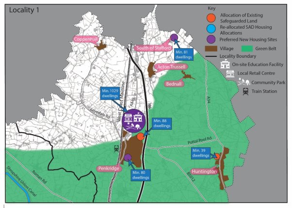
Penkridge
5.26 Housing growth in this part of the district will be driven by a large-scale extension in the Open Countryside to the north of Penkridge. This larger scale development will deliver significant housing growth alongside a mix of other uses, including a new first school, local retail and a country park. This recognises the recommendations for a large-scale extension north of Penkridge in the GBBCHMA Strategic Growth Study, the non-Green Belt land available in this area of the village and the greater level of services and facilities in Penkridge compared to other villages in the district, including access to a railway station. The council has also proposed an additional amount of limited Green Belt release to the south of the village, recognising Penkridge's status as a Tier 1 settlement and the sustainability of this location compared to other areas of the district.
5.27 The delivery of the existing non-Green Belt safeguarded land in the village will also be brought forward, to ensure that sustainable non-Green Belt sites in the district are delivered.
Southern Edge of Stafford (A34 corridor)
(2) 5.28 This location will not be a focus for larger-scale housing growth. This recognises the sensitive landscape and potential highways concerns that larger scale growth in this location could cause, as well as the lack of unmet housing needs in Stafford and the location's remoteness from areas where unmet needs are generated. Instead, a smaller scale extension to the adjacent town of Stafford will be delivered in this area, which will ensure the sustainable delivery of non-Green Belt housing land in the district.
Huntington
5.29 Housing growth in the village will be limited to existing planning permissions and the safeguarded land previously identified adjacent to the village. This approach recognises that Huntington is a Tier 2 settlement and therefore Green Belt release would not align with the spatial strategy which focuses Green Belt release only on the most sustainable Tier 1 settlements. This also recognises the relative level of services and facilities in Huntington compared to some other settlements in the district and potential for impacts on the nearby Cannock Chase AONB.
Housing growth in Locality 2
5.30 The diagram below summarises where new housing growth will be delivered in Locality 2 (the north-west of the district).
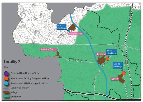
Brewood
(5) 5.31 Housing growth in the village will be limited to existing planning permissions and the safeguarded land previously identified adjacent to the village. This approach recognises that Brewood is a Tier 2 settlement and therefore Green Belt release would not align with the spatial strategy which focuses Green Belt release only on the most sustainable Tier 1 settlements. This also recognises the historic character of the village and relative level of services and facilities in Brewood compared to some other settlements in the district.
Coven
5.32 Housing growth in the village will be limited to existing planning permissions and the delivery of the safeguarded land adjacent to the village. This approach recognises that Coven is a Tier 3 settlement and therefore Green Belt release would not align with the spatial strategy which focuses Green Belt release only on the most sustainable Tier 1 settlements. This also recognises the limited level of services and facilities in Coven compared to some other settlements in the district.
Wheaton Aston
5.33 Housing growth in the village will be delivered through limited land release to deliver an allocation of an existing allocated site to the south of the village. This approach recognises the village's relatively limited services and facilities, concerns raised by a statutory body and a lack of additional suitable non Green Belt options when considering sites through the site assessment process.
Housing growth in Locality 3
5.34 The diagram below summarises where new housing growth will be delivered in Locality 3 (the north-east of the district).
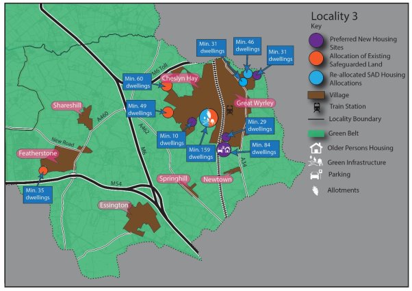
Cheslyn Hay/Great Wyrley
(1) 5.35 New housing growth in this area will be increased through the delivery of new allocations, which will be directed to less constrained site options around the two villages. These will be delivered alongside the existing allocated and safeguarded housing sites dispersed around the two villages.
5.36 The delivery of new housing allocations in Cheslyn Hay/Great Wyrley recognises the greater level of services and facilities to support local growth in these villages and the potential for additional allocations to be made to address the acute local need for specialist elderly housing in this location. Unlike other Tier 1 settlements (Penkridge & Codsall/Bilbrook), growth in Cheslyn Hay/ Great Wyrley is tempered by the site-specific constraints affecting numerous site options in this area.
Featherstone & Shareshill
5.37 Housing growth around the village will be limited to existing planning permissions, and the delivery of the safeguarded land adjacent to Featherstone. Green Belt release is not proposed in this area, recognising the villages Tier 3 status and that this would not align with the spatial strategy which focuses Green Belt release only on the most sustainable Tier 1 settlements.
Housing growth in Locality 4
5.38 The diagram below summarises where new housing growth will be delivered in Locality 4 (the central area of the district).
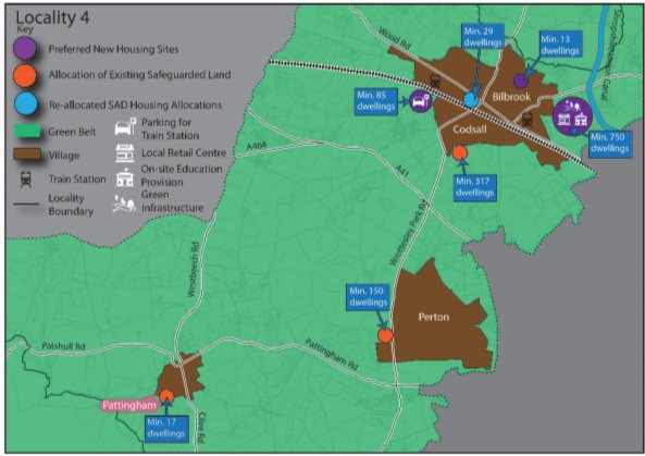
Codsall/Bilbrook
(2) 5.39 Housing growth in this part of the district will be largely focused on Codsall/Bilbrook. Increased allocations around the village will deliver housing growth alongside a mix of other uses, including a new first school, local retail and strategic green infrastructure. This recognises the recommendations for proportionate dispersal around Codsall/Bilbrook in the GBBCHMA Strategic Growth Study and the greater level of services and facilities in this area compared to other villages in the district, including access to two railway stations. The level of growth to be delivered is also aligned to the level of growth advised by the Education Authority to deliver an appropriately sized First School in this location whilst avoiding creating capacity issues at the Middle and High School level. It also offers opportunities to deliver additional station car parking at Codsall.
Perton
5.40 Housing growth in the village will be limited to existing planning permissions and the safeguarded land previously identified adjacent to the village, with no additional Green Belt release proposed. This approach recognises that Perton is a Tier 2 settlement and therefore Green Belt release would not align with the spatial strategy which focuses Green Belt release only on the most sustainable Tier 1 settlements. It is also recognised that highways concerns and proximity to education are also factors that limit suitable site options.
Pattingham
(1) 5.41 Housing growth in the village will be delivered through the delivery of the safeguarded land identified adjacent to the village, with no additional Green Belt release proposed. This approach recognises that Pattingham is a Tier 3 settlement and therefore Green Belt release would not align with the spatial strategy which focuses Green Belt release only on the most sustainable Tier 1 settlements. This also recognises the limited level of services and facilities in Pattingham compared to some other settlements in the district.
Housing growth in Locality 5
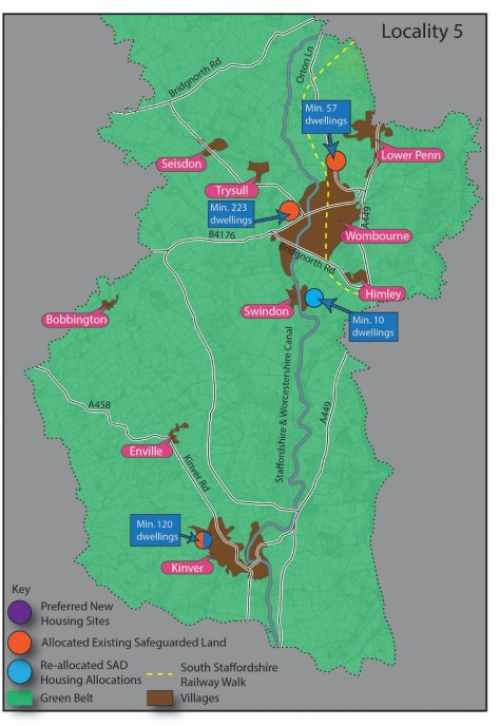
5.42 The diagram below summarises where new housing growth will be delivered in Locality 5 (the south of the district).
Wombourne
(1) 5.43 Housing growth in the village will be delivered through the delivery of the safeguarded land identified adjacent to the village, with no additional Green Belt release proposed. This approach recognises that Wombourne is a Tier 2 settlement and therefore Green Belt release would not align with the spatial strategy which focuses Green Belt release only on the most sustainable Tier 1 settlements. This recognises that unlike the Tier 1 settlements, Wombourne does not have rail access in walking distance that can offer greater sustainable access to employment and services.
Kinver
5.44 Housing growth in the village will be delivered through the delivery of the safeguarded land identified adjacent to the village, with no additional Green Belt release proposed. This approach recognises that Kinver is a Tier 2 settlement and therefore Green Belt release here would not align with the spatial strategy which focuses Green Belt release only on the most sustainable Tier 1 settlements. This also recognises the historic character of the village and relative level of services and facilities in Kinver compared to some other settlements in the district.
Swindon
5.45 Housing growth in the village will be delivered through a small existing site allocation. The safeguarded land in the village is not proposed for allocation as following its re-examination through our housing site assessment topic paper, is not considered suitable to accommodate a well designed scheme layout. This approach also recognises that Swindon is a Tier 3 settlement and therefore Green Belt release here would not align with the spatial strategy which focuses Green Belt release only on the most sustainable Tier 1 settlements.
Gypsies and Travellers
(2) 5.46 It is also a requirement of the Local Plan to assess and plan to meet the housing needs of different groups of the community, including Gypsies, Travellers and Travelling Showpeople. The government's Planning Policy for Traveller Sites (PPTS) 2015 details how travellers' housing needs should be assessed for those covered by the definition in Annex 1 of the 2012 PPTS. The focus of Gypsy, Traveller and Travelling Showpeople policies in this plan is therefore to make provision for those traveller families that meet the definition, with the housing needs of those not falling within this definition met through general needs housing policies.
5.47 In line with national policy, the needs for families have been assessed through the Gypsy and Traveller Accommodation Assessment (GTAA) update 2024 and Pitch Deliverability Study (2021). This evidence demonstrates that need is being generated by existing families. Some of this is current need as a result of being on an unauthorised pitch and overcrowding. However, the vast majority of need is generated through household formation derived from the demographics of residents and teenagers on sites needing a pitch of their own within the next five years.
5.48 Due to this, the council's strategy for new Gypsy, Traveller and Travelling Showperson provision will be to continue to deliver privately owned sites/pitches to meet the needs of existing families. The evidence supports an approach therefore of looking to allocate existing temporary or unauthorised sites to permanent (subject to other planning considerations) and looking to intensify and extend existing sites to meet identified family need, rather than allocating wholly new sites that may have been suggested by landowners without any connection or agreement to meet local needs, and where deliverability is more uncertain. This approach will see the continued concentration of traveller pitches where sites have historically been consented on appeal in the north of the district predominantly along the A449 and A5 transport corridors. It is currently not possible to test an alternative distribution of traveller pitches that would disperse pitches more widely across the district due to a lack of deliverable alternative pitch options elsewhere in the district.
5.49 The GTAA update (2024) has identified a need for 142 pitches to 2042 from families that meet the definition of a Gypsy and Traveller. However, assuming that 84% of 'undetermined household' (where interviews were not secured) would need a pitch, then this requirement could rise to 162 pitches up to 2042. The GTAA update identified a 5-year need (2024-2028) of 92 pitches.
Employment
The district's employment needs
(2) 5.50 It is the role of the Local Plan to consider the district's employment needs and plan for employment growth over the plan period, taking account of the evidence of need and the existing pipeline of employment land. A partial update of the Economic Development Needs Assessment (EDNA) was published in 2024 to inform the emerging Local Plan and was an update to a previous EDNA published in 2022.
5.51 The EDNA 2022 and 2024 update, in accordance with the PPG, analysed the socio-economic landscape of the district (including around employment, business development, demographics and labour markets) and concluded that the local economy in South Staffordshire was healthy and was still benefiting from investment particularly as a result of strategic site delivery in the district. The EDNA also analysed which authorities South Staffordshire had the strongest economic links with, and from this identified a Functional Economic Market Area (FEMA) comprising of South Staffordshire, Cannock, Dudley, Stafford, Walsall and Wolverhampton.
5.52 The study's main focus was to draw together the market intelligence, economic forecasts and other relevant data to conclude on the employment land needs of the district up until 2041. The study included detailed analysis of employment projections on a sector-by-sector basis utilising data from the three main forecasting houses. The study adjusted the Experian forecast to arrive at a 'LEP based Growth Scenario' and following a series of further adjustments (e.g. building in plan flexibility such as projected employment losses and an increased margin for frictional vacancy), arrived at an objectively assessed employment land need figure of 62.4ha up to 2041.
5.53 The study also undertook analysis on the impact of West Midlands Interchange (WMI) on the district, including on the demand for employment, as well as considering the proportion of WMI that could contribute towards the supply of employment land for South Staffordshire given the strategic nature of the site. This concluded that 18.8ha of WMI would contribute towards the district's supply of employment land to meet the projected demand.
(1) 5.54 The EDNA undertook further analysis by examining the supply/demand balance for the district, in order to inform the amount of employment land that would need to be allocated through the Local Plan. It considered the supply of employment land at the base date of April 2023 (circa 90ha, excluding WMI)) and explored how this would likely be split between strategic and non-strategic employment land supply. Following consideration of the supply/demand balance specifically for strategic sites, it was concluded what proportion of the surplus strategic employment land could be attributed to providing towards sub regional supply and what proportion could be considered providing towards South Staffordshire's supply, informed by the labour demand forecasts. It concluded that in terms of strategic employment land, 27.6ha of surplus land (excluding WMI) could reasonably be attributed to cross boundary unmet needs in the Black Country FEMA. This increases further to 45.2ha when factoring in an additional strategic allocation at M6 Junction 13, Dunston (17.6ha) that boosts the supply pipeline to ensure plan flexibility and that the pipeline of sites more closely reflect recent take up. Meanwhile, the supply-demand balancing exercise that could be attributed to South Staffordshire, taking on board both strategic and non-strategic employment land, concluded there is sufficient supply to meet the council's employment needs based on South Staffordshire's forecast labour demand, with supply/demand broadly in balance. Overall, the district can meet its own employment land needs, together with making a proportionate contribution to unmet needs in the Black Country.
Unmet employment needs from the wider functional economic area
(2) 5.55 National planning practice guidance requires authorities consider the 'most appropriate geography' to prepare policies for employment and require authorities to define their 'best fit' Functional Economic Market Area. Given this, it is over the South Staffordshire FEMA geography that it is considered the most appropriate basis for considering our role in meeting cross boundary employment needs.
5.56 Of the other authorities within the South Staffordshire FEMA, Cannock Chase District Council (CCDC) are also in the process of preparing their new Local Plan. In February 2024 they consulted on their Pre-Submission (Regulation 19) consultation which indicated that up to 74ha of employment land will be provided over the plan period up to 2040 to meet Cannock's employment needs. There is currently no indication that Cannock are unable to meet this need within their administrative boundary, with the exception being confirmation that they require 10ha from WMI. Stafford Brough consulted on their Preferred Options document in October 2022 which confirmed around 156ha of employment land supply over their emerging plan period. There is no indication to date that Stafford will not be able to meet its own development needs.
5.57 The Black Country authorities of Dudley, Sandwell and Wolverhampton are also currently preparing their Local Plans and their employment evidence has identified a self-contained Black Country FEMA covering the four Black Country authorities, albeit with strong and moderate links to a number of neighbouring authorities, including strong links with South Staffordshire. The Black Country authorities latest Employment Land Needs Assessment (October 2023) identifies a shortfall of 153ha of employment land. That study recommends that the Black Country local authorities should continue to engage through the Duty to Cooperate with neighbouring authorities that have a strong or moderate functional economic relationship with the Black Country to consider this shortfall.
5.58 Site assessment of employment site options (existing sites with available land parcels and new site options) have been undertaken, which has re-confirmed that those sites assessed as part of the supply/demand exercise in the EDNA update (2024) and that did not have full or reserved matters planning permission at the base date of April 2023 are suitable for allocation. As such, the findings of the supply/demand exercise and the conclusion in the EDNA update (2024) that 27.6ha (excluding WMI and M6 Junction 13, Dunston) of strategic employment land is available for unmet cross boundary needs has been confirmed. In addition, WMI represents a significant supply of employment land within the district that will come forward within the plan period. As confirmed through the EDNA 2022 and 2024 update, South Staffordshire requires 18.8ha of WMI within our supply to meet our forecast labour demand, leaving a considerable proportion of the site available to meet cross boundary needs. The Black Country authorities commissioned a report considering the proportion of WMI that could be considered towards their needs based upon projected population change. This identified a minimum 67ha 'claim' from WMI for the Black Country authorities, which when taken alongside the 45.2ha[5] surplus of strategic employment land means that 112.2ha of employment land in South Staffordshire is available for strategic cross boundary unmet needs from the Black Country (circa 153ha shortfall), subject to agreement through a Statement of Common Ground.
Strategic Employment Sites
5.59 The issue of strategic employment delivery across the wider West Midlands region has started to be explored most recently through the West Midlands Strategic Employment Sites Study (WMSESS) 2021. The WMSESS 2021 was commissioned by Staffordshire County Council, Black Country LEP, Greater Birmingham and Solihull LEP and Coventry and Warwickshire LEP with local planning authorities in the region not directly involved in the study. In this context, the study's primary focus was around engagement with the private sector to gauge market demand for new strategic employment sites, to examine recent take up, and to identify broad areas of market demand. It did not provide a full assessment of need (in terms of floorspace) that could be attributable at across the study area, however it did conclude that there was considerable demand for strategic employment site opportunities across the region and identified a number of broad locations around key junctions, including junctions on the M6 and M54 in South Staffordshire.
Development Needs & Spatial Strategy to 2041
5.60 The development needs set out in Policy DS4, and spatial strategy set out in Policy DS5, describe how the district will meet its housing, Gypsy and Travellers and employment needs up to 2041; whilst sensitively managing other uses such as retail, agriculture and tourism. These are key strategic policies that set the framework for delivering growth through the Local Plan and provide details of how windfall developments will be considered that are proposed outside the Local Plan allocations process.
(117) Policy DS4: Development Needs
During the plan period up to 2041, the council will promote the delivery of a minimum of:
- 4,726 homes over the period 2023-2041 to meet the district's housing target, whist providing approximately 10% additional homes to ensure plan flexibility. This housing target includes the district's own housing requirement of 4,086 homes, plus a 640-home contribution towards unmet housing needs of the Greater Birmingham and Black Country Housing Market Area. The council will seek to demonstrate a 5 year housing land supply upon adoption of the plan.
- 107.45ha of employment land over the period 2023-2041 to ensure that South Staffordshire's identified need for employment land of 62.4ha is met, as well as making available a potential contribution of 45.2ha to the unmet employment land needs of the Black Country authorities.
18.8ha of West Midlands Interchange will contribute towards South Staffordshire's employment land supply with an additional minimum 67ha available towards the unmet employment land needs of the Black Country authorities, and which may increase depending on the employment land position of other local authorities in the site's market area. 10ha at WMI will also contribute towards Cannock Chase council meeting their employment land needs. The remaining land supply of West Midlands Interchange (WMI) will be considered with related authorities through the Duty to Co-operate. - 37 new Gypsy and Traveller pitches. This is the number of pitch options that have been assessed as deliverable against a larger need of 162 pitches, primarily to meet the future needs of existing families within the district. The council has explored numerous options to meet this unmet need, including through ongoing Duty to Co-operate engagement with neighbouring authorities and promoters of residential site allocations, as well as assessing the suitability of publicly owned land. The council will continue to work with Duty to Cooperate bodies to explore options for new or expanded public sites to meet this unmet need and will respond positively to windfall proposals that accord with Policy HC9.
Policies DS5, MA1, SA1, SA2, SA3, SA4 and SA5 set out how the above development needs will be delivered in a sustainable way that enhances the vitality of communities across South Staffordshire, supports economic growth, and which conserves and enhances the district's environmental assets. Delivery of new development will be monitored in line with the monitoring framework and the development needs set out above will be kept under review to inform whether a review of the Local Plan is required.
5.61 The spatial strategy and distribution the growth outlined in Policy DS4 is based upon a capacity led approach that focuses the majority of growth on the district's most sustainable settlements, with Green Belt release limited to these Tier 1 settlements. Non-Green Belt options have been maximised in line with national policy requirements with the limited number of suitable and deliverable brownfield site options in the district proposed for allocation as well as the reassessment of existing safeguarded land sites to confirm their suitability for allocation. Suitable sites in sustainable locations in the Open Countryside to the north of district are allocated, specifically adjacent the sustainable settlements of Penkridge and neighbouring Stafford. The spatial strategy also facilitates the delivery of key infrastructure where opportunities are presented (e.g. a new First School at Bilbrook).
(197) Policy DS5 – The Spatial Strategy to 2041
During the plan period to 2041, the council will deliver a minimum of 4,726 dwellings
The aim will be to meet needs in a manner which builds on the district's existing infrastructure and environmental capacity, whilst recognising opportunities to deliver local infrastructure opportunities identified within the district. Throughout the district, growth will be located at the most accessible and sustainable locations in accordance with the settlement hierarchy set out below. The council will work with partners to deliver the infrastructure, facilities and services required to support this growth.
An integral part of the Strategy will be to ensure that growth is distributed to the district's most sustainable locations, avoiding a disproportionate level of growth in the district's less sustainable settlements, whilst also recognising that very limited growth in less sustainable areas may be appropriate in limited circumstances set out in the settlement hierarchy below. It will also seek to maintain and enhance the natural and historic environment and the local distinctiveness of the district and retain and reinforce the current settlement pattern.
Tier 1 settlements
The district's Tier 1 settlements are Penkridge, Codsall/Bilbrook and Cheslyn Hay/Great Wyrley. These settlements hold a wider range of services and facilities and have access to key rail corridors into the adjacent towns and cities upon which the district relies for its higher order services and employment. The sustainable growth of these larger rural settlements will be delivered through appropriate allocations made in the Local Plan, consisting of sustainable and deliverable non-Green Belt land and suitable Green Belt site allocations.
These Tier 1 settlements will continue to support windfall housing growth, employment development and service provision, where it is consistent with other Local Plan policies. Proposals for retail and small-scale office development should be directed into the centres identified in Policy EC8, in a manner which reflects their role and function.
Tier 2 settlements
The district's Tier 2 settlements are Wombourne, Brewood, Kinver, Perton and Huntington. These settlements hold a wider range of services and facilities than other smaller settlements in the district's rural area. The sustainable growth of these larger rural settlements will be delivered through appropriate allocations made in the Local Plan, consisting of suitable and deliverable non-Green Belt site allocations.
These Tier 2 settlements will continue to support windfall housing growth, employment development and service provision, where it is consistent with other Local Plan policies. Proposals for retail and small-scale office development should be directed into the centres identified in Policy EC8, in a manner which reflects their role and function.
Tier 3 settlements
The district's Tier 3 settlements are Essington, Coven, Featherstone, Shareshill, Wheaton Aston, Pattingham and Swindon. These settlements hold a smaller range of services and facilities than Tier 1 and 2 settlements and as such are given a lesser level of growth. Limited growth in these smaller rural settlements will be delivered through appropriate allocations made in the Local Plan, consisting of suitable and deliverable non-Green Belt site allocations.
The district's Tier 3 settlements will continue to support limited windfall housing and employment growth to assist in meeting local needs, where it is consistent with other Local Plan policies. Employment development will be small in scale and aim to maintain the vitality and viability of these communities. Proposals for retail and small-scale office development should be directed into the centres identified in Policy EC8, in a manner which reflects their role and function.
Tier 4 settlements
The district's Tier 4 settlements are Bednall, Bishops Wood, Bobbington, Dunston, Himley, Seisdon and Trysull. These settlements will continue to support very limited windfall housing growth to assist in safeguarding the limited services and facilities in each village and to address local housing needs. Limited windfall housing growth will be supported only where it is consistent with other Local Plan policies.
Tier 5 settlements
The district's Tier 5 settlements are set out in the Rural Services and Facilities Audit 2021. These settlements are not intended to experience further housing or employment growth, owing to their poorer sustainability credentials, poorer public transport links and lack of services and facilities relative to other settlements within the district. New development in these locations will be limited to the conversion and re-use of redundant rural buildings to appropriate uses, in accordance with other development plan policies. On a case-by-case basis, the very limited redevelopment of previously developed land for housing may also be supported within these settlements where this would not increase unsustainable transport movements from the settlement in question and would not conflict with other Local Plan policies. Limited affordable housing to meet specified local needs in accordance with relevant Local Plan policies may also be supported.
The district's wider rural area
In the rural area outside of the district's existing settlements, the objective of the Spatial Strategy is to protect the attractive rural character of the countryside. To deliver this, new development will be restricted to particular types of development to support biodiversity, carbon sequestration, renewable and low carbon technologies, tourism, sport and recreation and the local rural economy and rural diversification, where this is consistent with other Local Plan policies. Other than the forms of residential development identified as being acceptable in rural areas in the NPPF, isolated housing growth away from the district's settlements will not be supported.
Growth adjacent to the town of Stafford
Housing growth will be located at the strategic allocation made adjacent to Stafford through this Local Plan, in order to facilitate sustainable growth at a non-Green Belt location. This is:
Land at Weeping Cross, west of the A34
The district's freestanding strategic employment sites
Outside of the district's rural settlements, support will continue to be given for employment and economic development at the district's six freestanding strategic employment sites (West Midlands Interchange, i54 South Staffordshire, Hilton Cross, ROF Featherstone/Brinsford, Four Ashes and M6 Junction 13, Dunston). Existing and proposed employment sites throughout the district will be safeguarded for their respective uses, in accordance with other Local Plan policies.
Gypsy, Travellers and Travelling Showpeople sites
The district will seek to meet existing Gypsy, Travellers and Travelling Showpeople needs as far as possible, pursuing a strategy of meeting evidenced needs where they arise throughout the district. To deliver this strategy, allocations in the Local Plan will be used to allow for the sustainable intensification, extension and regularisation of suitable existing sites, in a manner consistent with other development plan policies and local evidence on pitch deliverability. Windfall proposals for additional pitches will be considered on a case-by-case basis against the criteria in Policy HC9 and other relevant Local Plan policies.
Delivering the Strategy
The Spatial Strategy will be delivered through allocations made in this Local Plan and associated planning policies, ensuring development is sustainable, enhances the environment and provides any necessary mitigating or compensatory measures to address harmful implications. In all cases development should not conflict with the policies of the development plan.
[1] 37,900 homes as of the 2017 Birmingham Development Plan
[2] The Black Country Urban Capacity Review (2021)
[3] Cannock Chase District Council, Wolverhampton City Council, Dudley Metropolitan Borough Council, Sandwell Metropolitan Borough Council, Walsall Metropolitan Borough Council, Tamworth Borough Council, Birmingham City Council, South Staffordshire District Council, North Warwickshire District Council, Redditch Borough Council, Lichfield District Council, Bromsgrove District Council, Solihull Metropolitan Borough Council and Stratford on Avon District Council
[4] These figures incorporate planning permissions granted since 2023 as well as allocations and safeguarded land from the council's adopted Site Allocations Document (2018) that have yet to come forward
[5] 27.6ha (identified as surplus in the EDNA update) + 17.6ha (M6 Junction 13, Dunston) = 45.2ha.


