Preferred Options November 2021
4. Development Strategy
Green Belt
4.1 The distinctive character of South Staffordshire is directly influenced by the fact that around 80% of the district is Green Belt. This contributes to the district's rural character and helps distinguish the district from neighbouring urban areas such as the Black Country. Protecting the Green Belt from unplanned development as far as possible is therefore a key objective (Strategic Objective 1) of the Local Plan. However, national policy requires us to balance the need to protect the Green Belt with the need to deliver a sustainable growth strategy that meets the district's development needs, including for new housing and employment.
4.2 Therefore, it is proposed that Green Belt is only released through the Local Plan where necessary and fully justified. In line with national policy, Green Belt boundaries can only be amended through the review of a Local Plan, and therefore a policy setting out where the Council's development strategy requires such Green Belt amendments is necessary, as well as ensuring a strong policy framework for resisting planning applications that would result in inappropriate development in the Green Belt.
4.3 Wherever possible, the Council has looked to allocate suitable brownfield sites to reduce pressure on the District's Green Belt, however these very are limited due to the largely rural nature of the district. Most large-scale site options on brownfield land are either in isolated rural locations or form part of the District's employment land supply and need to be retained to ensure the District can meet its employment land needs. Previous Local Plans also identified large brownfield sites in the Green Belt (known as major developed sites in the Green Belt) but all of these have now been developed. There is an area of brownfield land adjacent to the south-western edge of Wombourne, which is mainly occupied by the car storage company Copart. This site has been assessed as an option for housing, however it is not proposed for allocation due to Staffordshire County Council highways team concerns, as well as uncertainty over the relocation of the existing business. Elsewhere, brownfield opportunities in sustainable locations tend to be small scale (e.g housing association garage sites, small infill plots, changes of use under permitted development) and if unconstrained have historically come forward through the Development Management process and outside of the Local Plan, as the principle of such schemes is generally considered acceptable. The Council has included a windfall allowance for these smaller site opportunities within the housing trajectory to ensure this is accounted for in future supply.
4.4 Where Green Belt release is necessary through the Local Plan, we will ensure that compensatory improvements to the environmental quality and accessibility of remaining Green Belt, including improving access to the countryside and ecological and biodiversity enhancement, are made. In order to deliver the vision for the district over the plan period it essential that we have a strong policy position for protecting the Green Belt as far as possible and this is set out in Policy DS1 below.
Policy DS1 – Green Belt
Within the West Midlands Green Belt, as defined on the policies map, opportunities to enhance the beneficial use of the Green Belt will be supported. This may include opportunities to provide access, for outdoor sport and recreation, to retain and enhance landscapes, visual amenity and biodiversity, or to improve damaged and derelict land.
Development within the Green Belt must retain its character and openness. Inappropriate development is, by definition, harmful to the Green Belt and will not be supported except in very special circumstances. Very special circumstances will not exist unless the potential harm to the Green Belt by reason of inappropriateness, and other harm, is clearly outweighed by other considerations.
The construction of new buildings within the Green Belt should be regarded as inappropriate, unless it is for one of the exceptions listed within the National Planning Policy Framework. These exceptions include limited infilling in villages, which will be defined as the filling of small gaps (1 or 2 buildings) within a built-up frontage of development which would not exceed the height of the existing buildings, not lead to a major increase in the developed proportion of the site, or have a greater impact on the openness of the Green Belt and the purpose of including land within it. A separate Green Belt Supplementary Planning Document (SPD) will be prepared for further guidance.
Limited affordable housing for local community needs in the Green Belt will be supported on small rural exceptions sites where the development complies with Policy HC6.
The Green Belt boundary will be altered through the Local Plan Review to accommodate development allocations set out in Policies SA1, SA2, SA3, SA5 and SA7. The boundaries of the reviewed Green Belt sites are identified in Appendices B-E of this document.
Open Countryside
4.5 Equally important to maintaining the special character of South Staffordshire is having a policy framework for protecting the Open Countryside located to the north west of the district beyond the Green Belt. Whilst not having the same level of national protection as Green Belt designation, the land designated in the Local Plan as Open Countryside is still much valued countryside particularly for its landscape and ecological qualities. It is therefore important as part of the district's wider development strategy, that a clear policy approach on what type of development is explicitly permitted in the Open Countryside is set out in the Local Plan. Equally, it will need to set out what policy factors proposals will need to be consistent with for development in the Open Countryside to be acceptable in principle.
Policy DS2 – Open Countryside
The district's Open Countryside is defined as the area in the district which is both beyond the West Midlands Green Belt and outside of individual settlements' development boundaries, as indicated on the Policies Map.
The Open Countryside contains many sensitive areas, including its landscapes and areas of ecological, historic, archaeological, agricultural and recreational value. To plan sensitively for development whilst protecting these assets, the principle of development will be supported in the Open Countryside where it is for:
- A new or extended building, provided it is for:
- purposes directly related to agriculture or forestry; or
- appropriate facilities for outdoor sport or recreation, nature conservation, cemeteries and for other uses of land which preserve the appearance or character of the Open Countryside; or
- affordable housing where there is a proven local need in accordance with Policy HC6; or
- limited infilling and limited extension(s), alteration or replacement of an existing building where the extension(s) or alterations are not disproportionate to the size of the original building; or
- redevelopment of previously developed land which would not harm the intrinsic character and beauty of the Open Countryside.
- The re-use of a building, provided that:
- the proposed use of any building (taking into account the size of any extensions, rebuilding or required alterations), would not harm the intrinsic character and beauty of the Open Countryside.
- Changes of use of land:
- the carrying out of engineering or other operations, or the making of a material change of use of land, where the works or use proposed would not harm the intrinsic character and beauty of the Open Countryside and would be consistent with the district's Spatial Strategy as set out in Policy DS3
The policy provisions set out above indicate the types of development which will, in principle, be supported within the Open Countryside. In addition to the requirements set out in this policy, any proposed scheme must also be consistent with any relevant policies set out elsewhere within the Local Plan in order to be supported.
All types of development in the Open Countryside which are not explicitly supported by Policy DS2 will be considered on a case-by-case basis. Such proposals will only be permitted where they are not located on best and most versatile agricultural land and are fully consistent with any other relevant policies set out elsewhere in the Local Plan. These include, but are not limited to, policies which relate to the district's:
- overall development strategy
- design standards
- landscape character and assets
- historic assets
- ecological assets and biodiversity
- recreational assets
- housing mix requirements (where applicable)
- sustainable travel requirements
The Open Countryside boundary will be altered through the Local Plan Review to accommodate the relevant development allocations set out in Policies SA4 and SA5. The boundaries of the reviewed Open Countryside sites are identified in Appendices B and C of this document.
(205) Question 4:
Do you support the policy approach in Policy DS1 – Green Belt and Policy DS2 – Open Countryside? Yes/No
If no, please explain how these policies should be amended?
Housing
The district's housing needs
4.6 A key part of the new Local Plan is to establish the role that South Staffordshire Council can play in both meeting its own housing needs and those of the wider Greater Birmingham Housing Market Area (GBHMA), which contains local authorities with significant unmet housing needs (Birmingham and the Black Country).
4.7 The plan period is proposed to run from 2018 onwards, so it is also necessary for the plan to take account of the 750 dwellings already delivered in the district between 2018-2021 in any future housing needs. The district's future housing need is then calculated using the government's standard method for calculating housing needs and added to this figure. This currently requires the district to deliver a minimum annual average of 243 dwellings per annum, starting from the current year (2021) and running to the end of the plan period (2038).
Unmet housing needs from the wider housing market area
4.8 In addition to the district's own housing needs, there is emerging evidence of unmet needs from the wider GBHMA, within which South Staffordshire sits. The two most significant sources of potential unmet needs are currently Birmingham City and the Black Country. The adopted Birmingham Development Plan[1] and emerging urban capacity evidence from the Black Country[2] suggests that a significant unmet need is arising across the GBHMA, driven by limited housing land in these urban areas.
4.9 Recognising the existing and emerging shortfalls, the fourteen GBHMA local authorities[3] jointly prepared the GBHMA Strategic Growth Study in 2018. This drew together existing evidence on housing supply and need across the entire housing market area, estimating that at that time the unmet needs of the GBHMA sat at around 28,000 dwellings up to 2031, rising to nearly 61,000 dwellings by 2036.
4.10 In light of these unmet needs, the study recommended a series of strategic growth locations across the housing market area, including a number of locations in South Staffordshire. Using this evidence, we proposed to test an additional contribution of 4,000 dwellings to the unmet housing needs of the GBHMA in our Local Plan review, based on the scale of growth implied in the district by the strategic locations identified in the GBHMA Strategic Growth Study. The district's proposed contribution to wider unmet housing needs was initially proposed in the previous 2018 Issues and Options consultation. This was done to ensure that the level of growth capable of being accommodated in South Staffordshire was based on a consistent HMA evidence base that consistently considered the sustainability, deliverability and infrastructure of strategic locations across the GBHMA. It also ensured that the issue of unmet housing needs was considered from the earliest stage possible in the plan's preparation and to provide Duty to Cooperate partners with the chance to comment on the our approach from the earliest stage of the plan-making process.
4.11 Since we proposed to accommodate this level of growth in 2018, updated land supply statements produced by the GBHMA local authorities have indicated the extent of the housing shortfall up to 2031 appears to have fallen significantly, whilst also indicating that the Black Country's urban capacity evidence shows a significant level of housing need arising into the later 2030s[4]. This is also reflected in the Draft Black Country Plan consultation, which seeks to deliver housing in urban areas and through Green Belt release to meet the area's housing needs, delivering 47,837 homes within the Black Country up to 2039 whilst indicating a potential shortfall of 28,239 homes they seek to export through the Duty to Cooperate. Whilst the Council will be working with the Birmingham and the Black Country authorities to ensure that housing supply within their administrative areas is truly maximised prior to being exported to other areas[5], it still is clear from evidence to date that a significant housing shortfall is likely to remain across the GBHMA.
4.12 Correspondence to date from key Duty to Cooperate partners, particularly Birmingham City Council and the Black Country local authorities, has not raised concerns with the Council's proposed contribution; and currently the GBHMA-wide evidence base has not been updated to recommend alternative or additional strategic locations for housing growth. In light of the above factors, we consider that there is still a need to deliver the strategic growth recommended in the GBHMA Strategic Growth Study, in order to ensure that that emerging and existing shortfalls from the conurbation are addressed in a genuinely sustainable manner. We therefore propose retaining our 4,000 dwelling contribution towards the unmet needs of the housing market area and will adjust our housing target accordingly to deliver this.
The proposed housing target
4.13 Reflecting these issues, South Staffordshire is proposing to plan for a housing target of 8,881 dwellings between 2018 and 2038. This will allow the district to meet its own housing needs over the plan period, whilst also making a proportionate and justified contribution to the unmet needs of the GBHMA. The specific elements of the housing target can be summarised as set out below:
|
South Staffordshire's own housing need using the government's standard method (2021-2038) |
4,131 |
|
Completions in the District since the start of the plan period (2018-2021) |
750 |
|
Additional housing to contribute towards the unmet needs of the GBHMA |
4,000 |
|
Total number of dwellings to be planned for |
8,881 |
Table 7: Housing Target
Spatial strategy for housing
4.14 To consider how this level of housing growth could be accommodated, the district previously consulted on a Spatial Housing Strategy and Infrastructure Delivery (SHSID) consultation in October 2019. This looked at how the proposed housing target could be distributed between different settlements and other broad locations within the district, informed by strategic evidence on the sustainability and sensitivity of these different locations. A preferred infrastructure-led spatial housing strategy was identified in this consultation (Option G).
4.15 As well as reflecting key policy and environmental constraints affecting the district, the Council's preferred strategy aimed to locate new housing in locations with better access to existing infrastructure and services or where new development could facilitate new infrastructure delivery. It also sought to deliver a balance of housing sites across the district, balancing the need for housing growth early in the plan period and for 10% of housing growth to be delivered on sites of less than 1 hectare, with the need for larger sites to deliver growth later in the plan period.
4.16 We thoroughly considered responses to the 2019 Spatial Housing Strategy and Infrastructure Delivery consultation and have refined the preferred spatial housing strategy to reflect some of the issues raised. We have also used the findings of the site assessment process (set out in full in the separate Housing Site Selection Topic Paper) to arrive at the exact level of growth given to each area of the district. In summary, key changes made are:
- Increasing growth proposed North of Penkridge to better reflect the findings of the GBHMA Strategic Growth Study and non-Green Belt land available north of the village;
- Allowing for further limited growth at Cheslyn Hay/Great Wyrley beyond the existing allocated/safeguarded land, recognising the area's Tier 1 settlement status, but balancing this against the lack of a strategic recommendation for these villages in the GBHMA Strategic Growth Study and the site specific constraints affecting land in the area;
- Limiting new allocations at Perton to the existing safeguarded land, reflecting the lack of a finalised junction improvement scheme at the A41 and the remoteness of Green Belt site options from education facilities;
- Reducing the amount of growth allocated to the western edge of the Black Country, reflecting the relatively limited unmet need arising from Dudley Metropolitan Borough, which also holds significant Green Belt site options in this area within its own administrative boundary as set out in the GBHMA Strategic Growth Study;
- Removing the proposal to identify small site allocations in Tier 4 villages, as current monitoring information suggests these allocations are not required to meet the national requirement for 10% of housing growth to be delivered on sites of less than 1 hectare;
- Identifying villages, namely Brewood and Great Wylrey, where specialist elderly housing allocations may address existing imbalances between local needs and supply[6]
4.17 Taken together, these factors have led to a slightly revised spatial strategy for housing delivery in the district, which distributes housing delivery across the plan period as set out in the Table 8. These figures incorporate planning permissions granted since 2018 as well as allocations and safeguarded land from the Council's adopted Site Allocations Document (2018) that have yet to come forward.
|
Spatial Housing Strategy 2018 - 2038 |
Indicative minimum dwelling numbers 2018-2038[7] |
|||
|
Location |
Total proportion of housing delivery |
Existing planning permissions and allocations |
Safeguarded land |
New allocations |
|
The district's rural area |
|
|
|
|
|
Tier 1 villages |
39.7% |
1151 |
890 |
1939 |
|
Penkridge |
17.2 % |
504 |
88 |
1129 |
|
Codsall/Bilbrook |
16.7 % |
423 |
584 |
666 |
|
Cheslyn Hay/Great Wyrley |
5.8 % |
224 |
218 |
144 |
|
Tier 2 villages |
17.0% |
723 |
614 |
370 |
|
Wombourne |
8.0 % |
289 |
280 |
239 |
|
Brewood |
1.8 % |
76 |
63 |
43 |
|
Kinver |
2.5 % |
123 |
82 |
44 |
|
Perton |
3.7 % |
226 |
150 |
0 |
|
Huntington |
0.9 % |
9 |
39 |
44 |
|
Tier 3 villages |
6.1% |
466 |
104 |
81 |
|
Essington |
2.3 % |
235 |
0 |
0 |
|
Coven |
1.1 % |
64 |
48 |
0 |
|
Featherstone |
1.2 % |
84 |
39 |
0 |
|
Shareshill |
0.0 % |
1 |
0 |
0 |
|
Wheaton Aston |
1.0 % |
67 |
0 |
37 |
|
Pattingham |
0.5 % |
7 |
17 |
22 |
|
Swindon |
0.3 % |
8 |
0 |
22 |
|
Tier 4 villages |
0.3% |
30* |
0 |
0 |
|
Growth in other rural locations and Tier 5 settlements |
2.6% |
258* |
0 |
0 |
|
Areas adjacent to neighbouring towns and cities |
|
|
|
|
|
Employment-led growth at Land at Cross Green (Brewood and Coven Ward) |
12.0% |
0 |
0 |
1,200 |
|
Northern edge of the Black Country at Land north of Linthouse Lane (Essington Ward) |
12.0% |
0 |
0 |
1,200 |
|
Western edge of the Black Country at Land at Langley Road (Wombourne North and Lower Penn Ward) |
3.9% |
0 |
0 |
390 |
|
South of Stafford at Land at Weeping Cross (Penkridge North East and Acton Trussell Ward) |
1.7% |
0 |
0 |
168 |
|
Other sources of supply |
|
|
|
|
|
Windfall development on small sites |
4.5% |
450 |
0 |
0 |
Table 8: How housing growth will be distributed across the district
4.18 In total, this distribution of growth exceeds the minimum amount of land release required to meet the district's 8,881 dwellings housing target. This will help the plan to meet the national policy requirement to respond to changing circumstances in the plan period.
4.19 Housing number for each village/broad location are influenced by the need to distribute the overall housing requirement sustainability to reflect the settlement hierarchy, (as informed by our Rural Services and Facilities Audit 2021); the evidence base (e.g. GBHMA Strategic Growth Study 2018);the level of constraints present around each village/broad location; and national policy factors (e.g. the requirement for 10% of site to be less than 1ha).The full set of factors were considered in the 2019 SHSID consultation document.
4.20 The sections that follow set out the strategy for delivering this housing growth in different areas of the district. The diagrams and descriptions that follow summarise only the locations that will be the focus for new housing allocations. They do not include existing planning permissions within the district, which make up the remainder of the housing growth for the plan period up to 2038, as set out in Table 8.
Housing growth in Locality 1
4.21 The diagram below summarises where new housing growth will be delivered in Locality 1 (the north of the district).
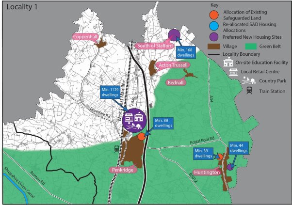
Penkridge
4.22 Housing growth in this part of the district will be driven by a large-scale extension in the Open Countryside to the north of Penkridge. This larger scale development will deliver significant housing growth alongside a mix of other uses, including a new first school, local retail and a country park. This recognises the recommendations for a large-scale extension north of Penkridge in the GBHMA Strategic Growth Study, the non-Green Belt land available in this area of the village and the greater level of services and facilities in Penkridge compared to other villages in the district, including a railway station. The Council has increased the level of growth proposed in this location since the previous Local Plan review consultation to ensure the delivery of sustainable non-Green Belt land in this location is maximised, and to ensure that the necessary infrastructure to support housing growth in this area can be delivered.
4.23 The delivery of the existing non-Green Belt safeguarded land in the village will also be brought forward, to ensure that sustainable non-Green Belt sites in the district are delivered.
Southern Edge of Stafford (A34 corridor)
4.24 This location will not be a focus for larger-scale housing growth. This recognises the sensitive landscape and potential highways concerns that larger scale growth in this location could cause, as well as the lack of unmet housing needs in Stafford and the location's remoteness from areas of unmet needs in the wider GBHMA. Instead, a smaller scale extension to the adjacent town of Stafford will be delivered in this area, which will ensure the sustainable delivery of non-Green Belt housing land in the district.
Huntington
4.25 Housing growth in the village will be delivered through limited land release alongside the delivery of the safeguarded land identified adjacent to the village. This approach balances the sensitive landscape in the area surrounding the village, including AONB, the extent of Green Belt land in this area and the relative reduced level of services and facilities in Huntington compared to other settlements in the district.
Housing growth in Locality 2
4.26 The diagram below summarises where new housing growth will be delivered in Locality 2 (the north-west of the district).
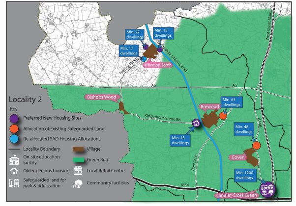
Land at Cross Green
4.27 Housing growth in this part of the district will be driven by a large-scale housing site at Land at Cross Green. Growth in this area will deliver significant housing alongside a mix of other uses, including a new primary school, local retail and strategic green infrastructure. It also provides the opportunity to safeguard land to deliver the rail-based parkway opportunity identified in the district's existing Core Strategy adjacent to the West Coast Mainline. Delivering housing growth in this location recognises the recommendations for a strategic housing site in this area in the GBHMA Strategic Growth Study and the area's proximity to significant employment opportunities at the i54 and ROF Featherstone strategic employment sites. It also recognises the infrastructure that could be facilitated by large scale growth and the area's proximity to the City of Wolverhampton, with its associated services and employment opportunities.
Brewood
4.28 Housing growth in the village will be delivered through limited land release alongside the delivery of the safeguarded land identified adjacent to the village. This approach balances the historic character of the village, the extent of Green Belt land in this area and the relative level of services and facilities in Brewood compared to other settlements in the district. It also recognises the potential for additional allocations to be made to address the acute local need for specialist elderly housing in this location.
Coven
4.29 Housing growth in the village will be limited to existing planning permissions, sites within the existing development boundary of the village and the delivery of the safeguarded land adjacent to the village. This approach recognises the existing housing growth already delivered around the village during the plan period, the village's relatively limited services and facilities and its proximity to more sustainable larger scale growth options proposed adjacent to the northern edge of the Black Country.
Wheaton Aston
4.30 Housing growth in the village will be delivered through limited land release to deliver multiple small sites of less than one hectare within and around the village. This approach recognises the existing housing growth already delivered around the village during the plan period and the village's relatively limited services and facilities, balanced against the non-Green Belt land opportunities available in and around the village.
Housing growth in Locality 3
4.31 The diagram below summarises where new housing growth will be delivered in Locality 3 (the north-east of the district).
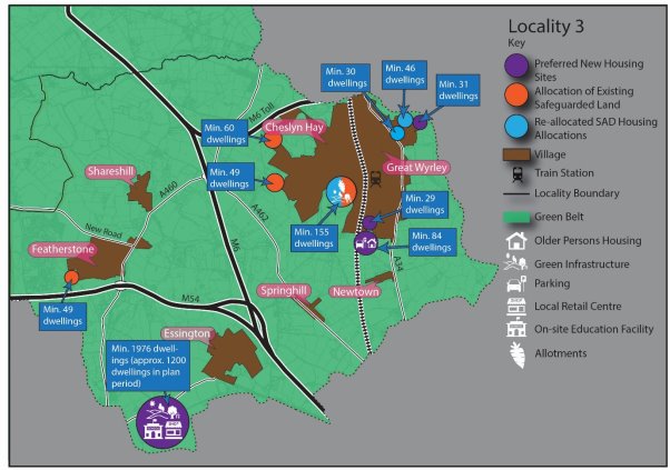
Cheslyn Hay/Great Wyrley
4.32 New housing growth in this area will be increased through the delivery of new allocations, which will be directed to less constrained site options around the two villages. These will be delivered alongside the existing allocated and safeguarded housing sites dispersed around the two villages.
4.33 The Council has increased the level of growth proposed in this location since the previous Local Plan review consultation, by proposing some new additional allocations as well as the existing allocated sites and safeguarded land in this area. The delivery of new housing allocations in Cheslyn Hay/Great Wyrley recognises the greater level of services and facilities to support local growth in these villages and the potential for additional allocations to be made to address the acute local need for specialist elderly housing in this location. Unlike other Tier 1 settlements (Penkridge & Codsall/Bilbrook), growth in Cheslyn Hay/ Great Wyrley is tempered by the lack of a large-scale growth identified for the villages in the GBHMA Strategic Growth Study, the alternative options to locate growth to meet GBHMA unmet needs directly adjacent to the northern edge of the Black Country and the site-specific constraints affecting growth in this area.
Northern edge of the Black Country
4.34 Housing growth in this part of the district will be driven by a large-scale housing site (land north of Linthouse Lane) adjacent to the northern edge of the Black Country urban area. Growth in this area will deliver significant housing alongside a mix of other uses, including a new primary school, local retail and strategic green infrastructure. Delivering housing growth in this location recognises the infrastructure that could be facilitated on a larger strategic housing site and the area's proximity to the higher order services and facilities in the cities and towns of the Black Country.
Featherstone & Shareshill
4.35 Housing growth around these villages will be limited to existing planning permissions, sites within the existing development boundaries of the villages and the delivery of the safeguarded land adjacent to Featherstone. This approach recognises both villages' relatively limited services and facilities, their proximity to more sustainable larger scale growth options proposed adjacent to the northern edge of the Black Country and the existing growth already delivered at Featherstone during the plan period.
Essington
4.36 Housing growth in the village will be limited to sites within Essington's existing development boundary and existing planning permissions around the village. This approach recognises the significant existing housing growth already delivered around the village during the plan period, the village's relatively limited services and facilities and its proximity to more sustainable larger scale growth options proposed adjacent to the northern edge of the Black Country.
Housing growth in Locality 4
4.37 The diagram below summarises where new housing growth will be delivered in Locality 4 (the central area of the district).
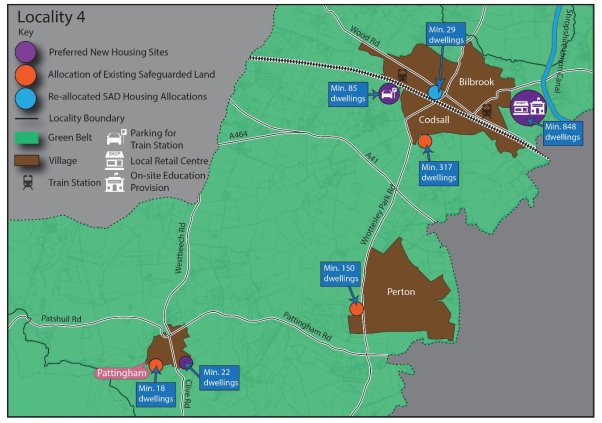
Codsall/Bilbrook
4.38 Significant housing growth in this part of the district will be focused on Codsall/Bilbrook. Increased allocations around the village will deliver significant housing growth alongside a mix of other uses, including a new first school, local retail and strategic green infrastructure. This recognises the recommendations for proportionate dispersal around Codsall/Bilbrook in the GBHMA Strategic Growth Study and the greater level of services and facilities in this area compared to other villages in the district, including two railway stations. The level of growth to be delivered is also aligned to the level of growth advised by the Education Authority to deliver a new 2 Form Entry First School in this location and may also offer opportunities to deliver additional station car parking at Codsall.
Perton
4.39 The Council has reduced the level of growth proposed in this location since the previous Local Plan review consultation, removing the recommendation for a new land allocation in this area. This change recognises the significant constraints identified in the site assessment process affecting new site options around the village, including highways concerns, proximity to education and Green Belt/landscape sensitivities. Because of these issues and the need to only release Green Belt in exceptional circumstances, housing growth in Perton will be limited to existing planning permissions, sites within the existing development boundaries of the villages and the delivery of the safeguarded land adjacent to Perton.
Pattingham
4.40 Housing growth in the village will be delivered through an additional small site allocation alongside the delivery of the safeguarded land identified adjacent to the village. This approach recognises the extent of Green Belt land in this area and the limited level of services and facilities in Pattingham compared to other settlements in the district. It also has regard to the opportunities for smaller villages in the district to help the Council meet its duty to allocate a certain proportion of growth on sites of less than one hectare.
Housing growth in Locality 5
4.41 The diagram below summarises where new housing growth will be delivered in Locality 4 (the south of the district).
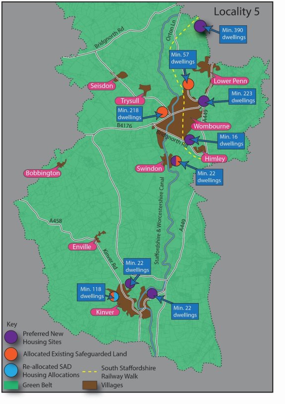
Wombourne
4.42 Housing growth in this area will be increased through the delivery of new housing allocations around Wombourne, which will be brought forward alongside the existing allocated and safeguarded housing sites dispersed around the village. First consideration will be given to any previously developed land in the Green Belt, where these can be shown to be deliverable and sustainable, before less constrained sites elsewhere in the Green Belt surrounding the village are considered.
4.43 This approach recognises, the potential opportunities presented by previously developed land and areas of lower Green Belt harm around the village area and the relative level of services and facilities in Wombourne compared to other settlements in the district. Whilst priority has been given to previously developed land in identifying locations for housing growth, site constraints have also meant that greenfield areas of lesser Green Belt harm have also needed to be considered.
Western edge of the Black Country
4.44 Housing growth will be delivered adjacent to the western edge of the Black Country, allowing for the limited expansion of the Black Country urban area. This will be delivered through a smaller urban extension to the Black Country, directed onto a less constrained site option within the Green Belt.
4.45 This area provides an opportunity to accommodate housing growth directly adjacent to the towns and cities within the Black Country, in a location identified as a strategic priority for dispersed housing growth in the GBHMA Strategic Growth Study. These factors have been balanced against the poorer access to employment via sustainable transport measures in this broad location and the lack of larger scale site options to deliver sustainable mixed-use growth in this area. The extent of land adjacent to Dudley Metropolitan Borough Council has also informed the level of growth allocated in this area, as Dudley MBC has a relatively limited unmet housing need and significant Green Belt opportunities within its own administrative boundaries to address this need.
Kinver
4.46 Housing growth in the village will be delivered through additional small site allocations of less than one hectare alongside the delivery of the safeguarded land identified adjacent to the village. This approach balances the historic character of the village, the extent of Green Belt land in this area and the relative level of services and facilities in Kinver compared to other settlements in the district. It also has regard to the opportunities for smaller villages in the district to help the Council meet its duty to allocate a certain proportion of growth on sites of less than one hectare.
Swindon
4.47 Housing growth in the village will be delivered through an additional small site allocation alongside the delivery of the safeguarded land identified adjacent to the village. This approach recognises the extent of Green Belt land in this area and the limited level of services and facilities in Swindon compared to other settlements in the district. It also has regard to the opportunities for smaller villages in the district to help the Council meet its duty to allocate a certain proportion of growth on sites of less than one hectare.
Gypsies and Travellers
4.48 It is also the requirement of the Local Plan to assess and plan to meet the housing needs of different groups of the community, including Gypsies, Travellers and Travelling Showpeople. The Government's Planning Policy for Traveller Sites (PPTS) 2015 details how travellers' housing needs should be assessed for those covered by the definition in Annex 1 of that document. The focus of Gypsy and Traveller and Travelling Showpeople policies in this plan is therefore to make provision for those traveller families that meet this definition of Gypsies and Travellers and Travelling Showpeople set out in the PPTS, with the needs of those not meeting this definition met through general needs housing policies.
4.49 In line with national policy the needs for families have been assessed through the Gypsy and Traveller Accommodation Assessment (2021) and Pitch Deliverability Study (2021). This evidence demonstrates that need is being generated by existing families. Some of this is current need as a result of being on an unauthorised pitch and overcrowding. However, the vast majority of need is generated through household formation derived from the demographics of residents and teenagers on site needing a pitch of their own within the next five years.
4.50 Due to this, our strategy for new Gypsy, Traveller and Travelling Showperson provision will be to continue to deliver privately owned sites/pitches to meet existing family needs. The evidence supports an approach therefore of looking to allocate existing temporary or unauthorised sites to permanent (subject to other planning considerations) and looking to intensify and extend existing sites to meet identified family need, rather than allocating wholly new sites that may have been suggested by non-travellers, and where deliverability is more uncertain. This approach will see the continued concentration of traveller pitches where sites have historically been consented on appeal in the north of the district predominantly along the A449 and A5 transport corridors. Notwithstanding this, other than those considered through the Pitch Deliverability Study, the Council does not currently have alternative site options suggested by third parties where an alternative strategy of dispersing new pitch allocations more widely across the district could be tested. As part of the consultation, we are asking the question (see Question 9) of whether there are other site options to test an alternative approach
Employment
4.51 It is the role of the Local Plan to plan for employment growth in the district over the plan period taking account of the evidence of need and the existing supply of employment land. To inform this we published our Economic Development Needs Assessment (EDNA) in 2018 that set out a number of scenarios for future employment needs over the plan period. In line with the Planning Practice Guidance (PPG) requirements, the EDNA also undertook an analysis of South Staffordshire's Functional Economic Market Area (FEMA) and identified South Staffordshire as being in the same FEMA as Cannock Chase district, Dudley, Walsall and Wolverhampton.
4.52 The EDNA 2018 identified a need for South Staffordshire of 67ha under 'growth scenario 1 – past completions'. This represented a business-as-usual approach, although did project forward an element of sub regional employment sites that came forward as Regional Investment Sites. Under a higher growth scenario, 'growth scenario 2 – past completions and growth (GVA)' the EDNA identified a need for 86ha.
4.53 The EDNA 2018 identified that South Staffordshire has sufficient supply of developable employment land within the district (circa 105ha) to meet its own employment requirements over the plan period (to 2038), and when considered against the two demand scenarios resulted in a 38ha oversupply against 'growth scenario 1- past completions', and a 19ha oversupply against 'growth scenario 2 – Past completions and growth GVA' covering the period 2018-38. National guidance however requires authorities consider the 'most appropriate geography'[8] to prepare policies for employment and require authorities to define their 'best fit'[9]Functional Economic Market Area. Given this, it is over the South Staffordshire FEMA geography that it is considered the most appropriate basis for considering our role in meeting cross boundary employment needs.
4.54 Cannock Chase District Council is also in the process of preparing their new Local Plan and in February 2021 consulted on their Preferred Options which indicated that 50ha of employment land will be provided over the plan period to meet Cannock's employment needs. There is currently no indication that Cannock are unable to meet this need within their administrative boundary.
4.55 The Black Country authorities are also preparing their Local Plan with the Black Country Draft Plan (August 2021) confirming that they have a need of 565ha of employment up until the end of their plan period (2039). The Black Country Draft Plan confirms they are only able to deliver 355ha of this leaving a shortfall on 210ha. Their Draft Plan indicates that this unmet need should be exported.
4.56 Subsequent to the EDNA 2018 findings, South Staffordshire's employment land supply has increased significantly due to the recent consenting of a Strategic Rail Freight Interchange, known as West Midlands Interchange (WMI), at Four Ashes. As WMI already has consent through the Development Consent Order process, it is proposed that it is allocated and removed from the Green Belt (see Policy SA7 - Employment allocation - West Midlands Interchange). This sees the employment land supply in South Staffordshire increase to circa 340ha (see Table 9).
4.57 WMI significantly increases the known oversupply of employment land in South Staffordshire, and with this, the scope to contribute towards unmet needs elsewhere in the FEMA. Currently, of the authorities within the South Staffordshire FEMA, only the Black Country have declared unmet employment needs. However, the exact amount of the oversupply to be attributed to their unmet needs will need to be agreed through a Statement of Common Ground. This will be contingent on the amount of employment land required to meet South Staffordshire's needs, including ensuring we have sufficient plan flexibility to respond to changes in economic circumstances.
4.58 Given that South Staffordshire's EDNA was undertaken in 2017/18 it is our intention to prepare an updated EDNA prior to our Publication consultation to review whether the demand for employment land has changed, particularly in light of Brexit and Covid-19. This update will ensure that our employment evidence is up to date for submission of the Plan and will the form the basis for agreement through a Statement of Common Ground on how much of the district's oversupply of employment land is available for export to meet unmet needs in the FEMA.
Spatial Strategy to 2038
4.59 The spatial strategy for South Staffordshire set out in Policy DS3 sets out how the district will meet its housing, Gypsy and Travellers and employment needs up to 2038, whilst sensitively managing other uses such as retail, agriculture and tourism. It is a key strategic policy that sets the framework for delivering growth through the Local Plan and provides details of how windfall developments will be considered that are proposed outside the Local Plan allocations process.
4.60 The spatial strategy and distribution of growth is based upon an infrastructure led approach. This can mean different things for different locations. For larger strategic sites this may mean on site delivery on new infrastructure such as a new school or local centre. For smaller villages it may be about smaller scale infrastructure, such as delivering a local play space, or about planning for limited new development that will help sustain existing infrastructure (e.g local school) over the longer term.
Policy DS3 – The Spatial Strategy to 2038
During the plan period to 2038, the Council will deliver a minimum of 4,881 dwellings plus a contribution of 4,000 dwellings towards meeting the Greater Birmingham Housing Market Area shortfall.
The principal aim will be to meet needs in a manner which builds on the district's existing infrastructure and environmental capacity, whilst recognising opportunities to deliver local infrastructure opportunities identified within the district. Throughout the district, growth will be located at the most accessible and sustainable locations in accordance with the settlement hierarchy set out below. The Council will work with partners to deliver the infrastructure, facilities and services required to support this growth.
An integral part of the Strategy will be to ensure that growth is distributed to the district's most sustainable locations, avoiding a disproportionate level of growth in the district's less sustainable settlements, whilst also recognising that very limited growth in less sustainable areas may be appropriate in limited circumstances set out in the settlement hierarchy below. It will also seek to maintain and enhance the natural and historic environment and the local distinctiveness of the district and retain and reinforce the current settlement pattern.
Tier 1 settlements
The district's Tier 1 settlements are Penkridge, Codsall/Bilbrook and Cheslyn Hay/Great Wyrley. These settlements hold a wider range of services and facilities and have access to key rail corridors into the adjacent towns and cities upon which the district relies for its higher order services and employment. The sustainable growth of these larger rural settlements will be delivered through appropriate allocations made in the Local Plan.
These Tier 1 settlements will continue to support windfall housing growth, employment development and service provision, where it is consistent with other Local Plan policies. Proposals for retail and small-scale office development should be directed into the centres identified in Policy EC6, in a manner which reflects their role and function.
Tier 2 settlements
The district's Tier 2 settlements are Wombourne, Brewood, Kinver, Perton and Huntington. These settlements hold a wider range of services and facilities than other smaller settlements in the district's rural area. The sustainable growth of these larger rural settlements will be delivered through appropriate allocations made in the Local Plan.
These Tier 2 settlements will continue to support windfall housing growth, employment development and service provision, where it is consistent other Local Plan policies. Proposals for retail and small-scale office development should be directed into the centres identified in Policy EC6, in a manner which reflects their role and function.
Tier 3 settlements
The district's Tier 3 settlements are Essington, Coven, Featherstone, Shareshill, Wheaton Aston, Pattingham and Swindon. These settlements hold a smaller range of services and facilities than Tier 1 and 2 settlements and as such are given a lesser level of growth. Limited growth in these smaller rural settlements will be delivered through appropriate allocations made in the Local Plan.
The district's Tier 3 settlements will continue to support limited windfall housing and employment growth to assist in meeting local needs, where it is consistent with other Local Plan policies. Employment development will be small in scale and aim to maintain the vitality and viability of these communities. Proposals for retail and small-scale office development should be directed into the centres identified in Policy EC6, in a manner which reflects their role and function.
Tier 4 settlements
The district's Tier 4 settlements are Bednall, Bishops Wood, Bobbington, Dunston, Himley, Seisdon and Trysull. These settlements will continue to support very limited windfall housing growth to assist in safeguarding the limited services and facilities in each village and to address local housing needs. Limited windfall housing growth will be supported only where it is consistent with other Local Plan policies.
Tier 5 settlements
The district's Tier 5 settlements are set out in the Rural Services and Facilities Audit 2021. These settlements are not intended to experience further housing or employment growth, owing to their poorer public transport links and lack of services and facilities relative to other settlements within the district. New development in these locations will be limited to the conversion and re-use of redundant rural buildings to appropriate uses, in accordance with other development plan policies. On a case-by-case basis, the very limited redevelopment of previously developed land for housing may also be supported within these settlements where this would not increase unsustainable transport movements from the settlement in question and would not conflict with other Local Plan policies.
The district's wider rural area
In the rural area outside of the district's existing settlements, the objective of the Spatial Strategy is to protect the attractive rural character of the countryside. To deliver this, new development will be restricted to particular types of development to support biodiversity, carbon sequestration, renewable and low carbon technologies, tourism, sport and recreation and the local rural economy and rural diversification, where this is consistent with other Local Plan policies. Other than the forms of residential development identified as being acceptable in rural areas in the National Planning Policy Framework, isolated housing growth away from the district's rural settlements will not be supported.
Growth adjacent to the neighbouring towns and cities in the Black Country
Housing growth will be primarily located at the allocations made adjacent to the Black Country through this Local Plan, in order to facilitate sustainable growth of their towns and cities and to assist in meeting wider unmet housing needs from the housing market area. These are:
- Land at Cross Green
- Land north of Linthouse Lane
- Land at Langley Road
As part of delivering these sites, the Council will work cross-boundary with infrastructure bodies and statutory partners to ensure these sites are supported by any necessary infrastructure. In addition, the Council will continue to work with partners to seek opportunities to deliver a rail-based parkway on land safeguarded for this use through the Land at Cross Green development.
Growth adjacent to the town of Stafford
Housing growth will be primarily located at the strategic allocation made adjacent to Stafford through this Local Plan, in order to facilitate sustainable growth at a non-Green Belt location. This is:
- Land at Weeping Cross, west of the A34
The district's freestanding strategic employment sites
Outside of the district's rural settlements, support will continue to be given for employment and economic development at the district's five existing freestanding strategic employment sites (West Midlands Interchange, i54 South Staffordshire, Hilton Cross, ROF Featherstone/Brinsford and Four Ashes). Existing and proposed employment sites throughout the district will be safeguarded for their respective uses, in accordance with other Local Plan policies.
Gypsy, Travellers and Travelling Showpeople sites
The district will seek to meet existing Gypsy, Travellers and Travelling Showpeople needs as far as possible, pursuing a strategy of meeting evidenced needs where they arise throughout the district. To deliver this strategy, allocations in the Local Plan will be used to allow for the sustainable intensification, extension and regularisation of suitable existing sites, in a manner consistent with other development plan policies and local evidence on pitch deliverability. Windfall proposals for additional pitches will be considered on a case-by-case basis against the criteria in Policy HC8 and other relevant Local Plan policies.
Delivering the Strategy
The Spatial Strategy will be delivered through allocations made in this Local Plan and associated planning policies, ensuring development is sustainable, enhances the environment and provides any necessary mitigating or compensatory measures to address harmful implications. In all cases development should not conflict with the policies of the development plan.
(424) Question 5:
Do you support the policy approach in Policy DS3 – The Spatial Strategy to 2038? Yes/No
If no, please explain how this policy should be amended?
Longer Term Growth Aspirations for a new settlement
4.60 As well as setting the spatial strategy for the district up until 2038, the Local Plan will set out a criteria based policy (Policy DS4) setting the parameters for what a new settlement to be delivered beyond the plan would need to incorporate should a suitable option come forward. This reflects the Council's desire to proactively set the framework for what we would expect from a sustainable freestanding new settlement. This includes the identification of a specific area of search along a key transport corridor (A449/ West Coast Mainline corridor), recognising that this was the sole area of opportunity for new settlements identified in the district in the GBHMA Strategic Growth Study 2018.
Policy DS4 – Longer Term Growth Aspirations for a New Settlement
It is a key longer term aspiration of the Council to explore potential options within the district for a sustainable independent new settlement which has the capacity to accommodate the future housing and economic needs of the district. It is not anticipated that a new settlement will contribute to housing growth during the current plan period. Instead, it will form a key option that the Council will want to consider alongside alternatives in future plan-making, meaning it is important that work to identify any potential options begins now.
To provide a focus for future new settlement site proposals, the transport corridor formed by the A449 and West Coast Mainline between Wolverhampton and Stafford has been identified as a potential area of search for such proposals. This is shown indicatively in Appendix F of this document. The exact location of such a settlement and alternative growth options should be considered through the plan-making process as part of a subsequent review of the Local Plan. Key to this will be evidence supporting any future proposal's sustainability, infrastructure requirements, viability considerations, delivery mechanisms and future stewardship arrangements.
It is anticipated any new settlement would be of a scale that is self-sustaining and enables a genuine mix of vibrant mixed communities that support a range of local employment types and premises, education, retail opportunities, recreational and community facilities with a wide range of housing to meet the needs of the community.
The Council anticipates that in sustainably delivering this growth, any new settlement proposals will need to deliver the following objectives:
- Beautifully Designed: Create a place with a local identity, with well-connected and distinctive neighbourhoods and an attractive and functioning centre and public realm, delivering a design code and masterplan for the development with a strong local vision that emerges from collaborative community engagement at the earliest stages.
- Mixed Communities: Offer a range of high quality and distinctive housing types for both market and affordable housing, designed to meet the needs of all members of the community at all stages of life.
- Sustainable Size and Location: Be of a scale and size that provides a range of local employment types and premises, education, retail opportunities, recreational and community facilities to meet the day-to-day needs of new residents within the settlement. Where this is not realistically achievable, put in place measures to ensure the delivery of direct and convenient sustainable transport to higher order services and employment in nearby towns and cities (including the Black Country urban area).
- Transport: Reduce car dependency whilst allowing residents to meet their day-to-day needs via other means, designing a community that is easy to navigate with direct and high quality walking, cycling, rail and bus infrastructure.
- Green Infrastructure and Health: Be designed to provide the choices and chances for all to live a healthy life, including generous, accessible, and good quality green and blue infrastructure that improves health and wellbeing alongside wider opportunities for recreation, sport, biodiversity and enhancements to natural capital.
- Future-proofed: Support radical reductions in greenhouse gas emissions through the community's design, whilst also allowing for changing demographics, future growth, and the impacts of climate change including flooding risk and water availability. Ensure the delivery of durable landscapes and building design planned for generations to come, including anticipation of the opportunities presented by technological changes such as driverless cars and renewable energy measures.
- Infrastructure-led: Ensure the required infrastructure is delivered at the appropriate stage, with consideration given to phasing, delivery mechanisms, future maintenance and stewardship from the outset.
(145) Question 6:
Do you support the policy approach in and Policy DS4 –Longer Term Growth Aspirations for a New Settlement? Yes/No
If no, please explain how this policy should be amended?
[1] 37,900 homes as of the 2017 Birmingham Development Plan
[2] The Black Country Urban Capacity Review (2021)
[3] Cannock Chase District Council, Wolverhampton City Council, Dudley Metropolitan Borough Council, Sandwell Metropolitan Borough Council, Walsall Metropolitan Borough Council, Tamworth Borough Council, Birmingham City Council, South Staffordshire District Council, North Warwickshire District Council, Redditch Borough Council, Lichfield District Council, Bromsgrove District Council, Solihull Metropolitan Borough Council and Stratford on Avon District Council
[4] Greater Birmingham and Black Country Housing Market Area (GBBCHMA) Housing Need and Housing Land Supply Position Statement (July 2020)
[5] Particularly in areas with increased housing needs due to the city and urban centres uplift set out in Planning Practice Guidance
[6] Based on information collected in the Specialist Housing: Local Need and Site Allocations Topic Paper 2021
[7] These figures incorporate planning permissions granted since 2018 as well as allocations and safeguarded land from the Council's adopted Site Allocations Document (2018) that have yet to come forward
* Supply is made up of permissions for single dwellings through to a single permission for 34 dwellings. See Housing Site Assessment Topic Paper for full details
[8] Paragraph: 040 Reference ID: 61-040-20190315
[9] Paragraph: 026 Reference ID: 2a-026-20190220


