Preferred Options November 2021
Appendix C
Housing allocation maps and proformas
Tier 1
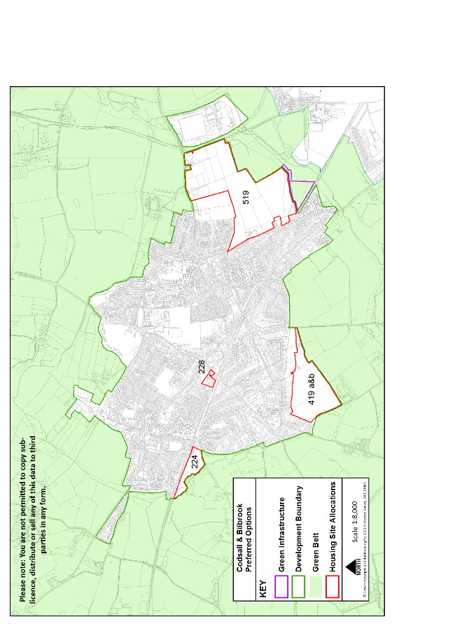
Bilbrook & Codsall
|
Site reference |
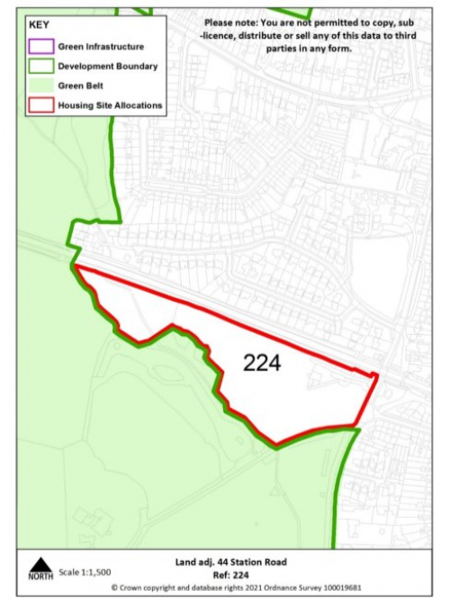
224 |
Village |
Codsall |
|
Minimum capacity |
85 dwellings |
Address |
Land adjacent to Station Road |
|
Site area |
4.0 ha |
Proposed use |
Housing |
|
|
|||
|
Key infrastructure requirements |
|
||
|
Proposed access |
Provide vehicular and pedestrian access via Station Road |
||
|
Site reference |
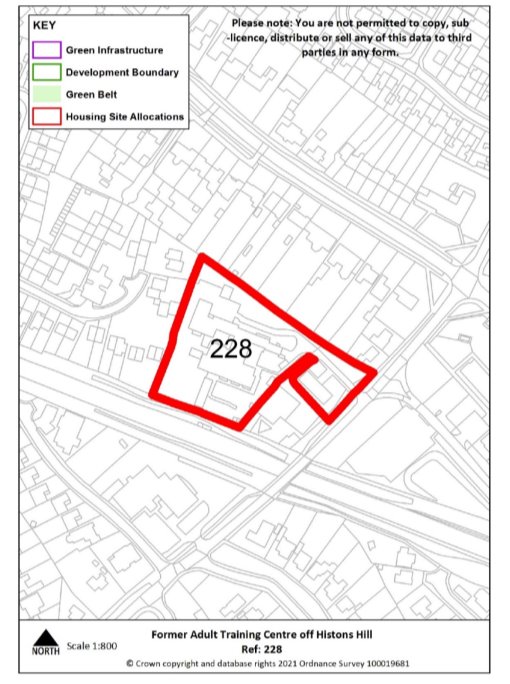
228 |
Village |
Codsall |
|
Minimum capacity |
29 dwellings |
Address |
Former Adult Training Centre off Histons Hill |
|
Site area |
0.8 ha |
Proposed use |
Housing |
|
|
|||
|
Key infrastructure requirements |
Any relevant policy requirements including affordable housing, open space, education, health, sports and recreation, energy efficiency, climate change mitigation, flood risk mitigation, highways, sustainable transport, housing mix and green infrastructure, delivered in line with the relevant development plan policy standards. |
||
|
Proposed access |
Provide vehicular and pedestrian access via Histons Hill. |
||
|
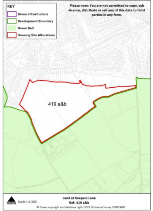
Site reference |
419 a&b |
Village |
Codsall |
|
Minimum capacity |
317 dwellings |
Address |
Land at Keepers Lane & Wergs Hall Rd |
|
Site area |
15.1 ha |
Proposed use |
Housing |
|
|
|||
|
Key infrastructure requirements |
Any relevant policy requirements including affordable housing, open space, education, health, sports and recreation, energy efficiency, climate change mitigation, flood risk mitigation, highways, sustainable transport, housing mix and green infrastructure, delivered in line with the relevant development plan policy standards. |
||
|
Proposed access |
Provide vehicular and pedestrian access via Wergs Hall Road and into the adjacent allocated housing site, including provision of a through road from Keepers Lane to Wergs Hall Road and extension of existing footway. |
||
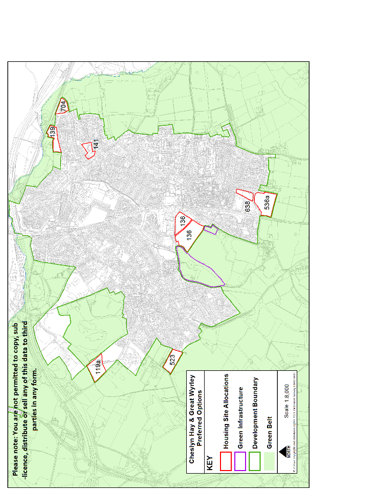
Cheslyn Hay & Great Wyrley
|
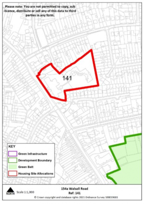
Site reference |
141 |
Village |
Great Wyrley |
|
Minimum capacity |
31 dwellings |
Address |
154a Walsall Road |
|
Site area |
1.2 ha |
Proposed use |
Housing |
|
|
|||
|
Key infrastructure requirements |
Any relevant policy requirements including affordable housing, open space, education, health, sports and recreation, energy efficiency, climate change mitigation, flood risk mitigation, highways, sustainable transport, housing mix and green infrastructure, delivered in line with the relevant development plan policy standards. |
||
|
Proposed access |
Provide vehicular and pedestrian access via Walsall Road. |
||
|
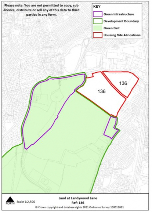
Site reference |
136 |
Village |
Great Wyrley |
|
Minimum capacity |
155 dwellings |
Address |
Land at Landywood Lane |
|
Site area |
7.4ha |
Proposed use |
Housing |
|
|
|||
|
Key infrastructure requirements |
|
||
|
Proposed access |
Provide vehicular and pedestrian access via Landywood Lane and Upper Landywood Lane, alongside pedestrian access into new country park. |
||
|
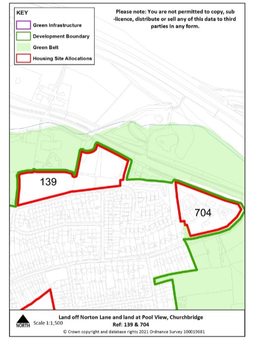
Site reference |
139 |
Village |
Great Wyrley |
|
Minimum capacity |
46 dwellings |
Address |
Pool View, Churchbridge |
|
Site area |
2.2 ha |
Proposed use |
Housing |
|
|
|||
|
Key infrastructure requirements |
Any relevant policy requirements including affordable housing, open space, education, health, sports and recreation, energy efficiency, climate change mitigation, flood risk mitigation, highways, sustainable transport, housing mix and green infrastructure, delivered in line with the relevant development plan policy standards. |
||
|
Proposed access |
Provide vehicular and pedestrian access via Pool View. |
||
|
Site Reference |
704 |
Village |
Great Wyrley |
||||
|
Minimum capacity |
31 |
Address |
Land off Norton Lane |
||||
|
Site area |
1.3 ha |
Proposed Use |
Housing |
||||
|
|
|||||||
|
Key infrastructure requirements |
Any relevant policy requirements including affordable housing, open space, education, health, sports and recreation, energy efficiency, climate change mitigation, flood risk mitigation, highways, sustainable transport, housing mix and green infrastructure, delivered in line with the relevant development plan policy standards. |
||||||
|
Proposed access |
Provide vehicular and pedestrian access via Norton Lane, including pedestrian crossing. |
||||||
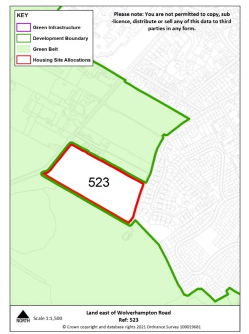
|
Site Reference |
523 |
Village |
Cheslyn Hay |
||||
|
Minimum capacity |
49 |
Address |
Land east of Wolverhampton Road |
||||
|
Site area |
2.4 ha |
Proposed Use |
Housing |
||||
|
|
|||||||
|
Key infrastructure requirements |
|
||||||
|
Proposed access |
Provide vehicular and pedestrian access via Wolverhampton Road and explore pedestrian access to Pinfold Lane |
||||||
|
Site Reference |
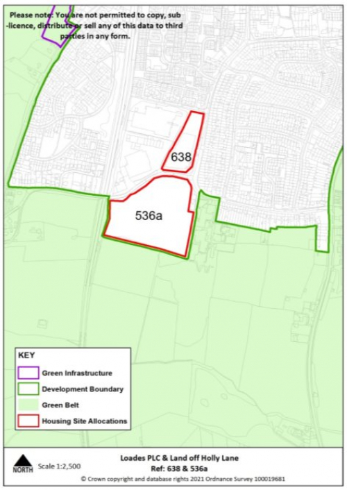
536a |
Village |
Cheslyn Hay |
||||
|
Minimum capacity |
84 |
Address |
Land off Holly Lane |
||||
|
Site area |
4 ha |
Proposed Use |
Housing |
||||
|
|
|||||||
|
Key infrastructure requirements |
|
||||||
|
Proposed access |
Provide vehicular and pedestrian access via Holly Lane. |
||||||
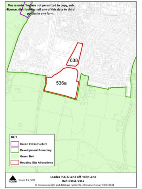
|
Site reference |
638 |
Village |
Great Wyrley |
|
Minimum capacity |
29 |
Address |
Loades PLC |
|
Site area |
1.1 ha |
Proposed use |
Housing |
|
|
|||
|
Key infrastructure requirements |
Any relevant policy requirements including affordable housing, open space, education, health, sports and recreation, energy efficiency, climate change mitigation, flood risk mitigation, highways, sustainable transport, housing mix and green infrastructure, delivered in line with the relevant development plan policy standards. |
||
|
Proposed access |
Provide vehicular and pedestrian access via Loades PLC. |
||
|
Site reference |
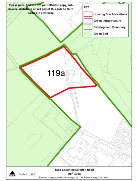
119a |
Village |
Cheslyn Hay |
|
Minimum capacity |
60 |
Address |
Land adjoining Saredon Road |
|
Site area |
2.9 ha |
Proposed use |
Housing |
|
|
|||
|
Key infrastructure requirements |
Any relevant policy requirements including affordable housing, open space, education, health, sports and recreation, energy efficiency, climate change mitigation, flood risk mitigation, highways, sustainable transport, housing mix and green infrastructure, delivered in line with the relevant development plan policy standards. |
||
|
Proposed access |
Provide vehicular and pedestrian access via Saredon Road, including extension of footway. |
||
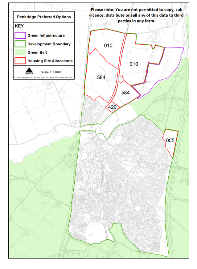
Penkridge
|
Site reference |
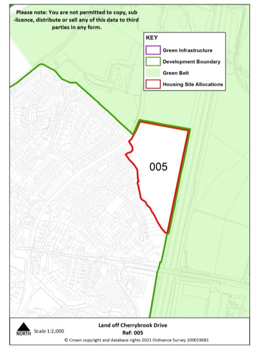
005 |
Village |
Penkridge |
|
Minimum capacity |
88 dwellings |
Address |
Land at Cherry Brook |
|
Site area |
4.2 ha |
Proposed use |
Housing |
|
|
|||
|
Key infrastructure requirements |
Any relevant policy requirements including affordable housing, open space, education, health, sports and recreation, energy efficiency, climate change mitigation, flood risk mitigation, highways, sustainable transport, housing mix and green infrastructure, delivered in line with the relevant development plan policy standards. |
||
|
Proposed access |
Provide vehicular and pedestrian access via Cherrybrook Drive. |
||
Tier 2
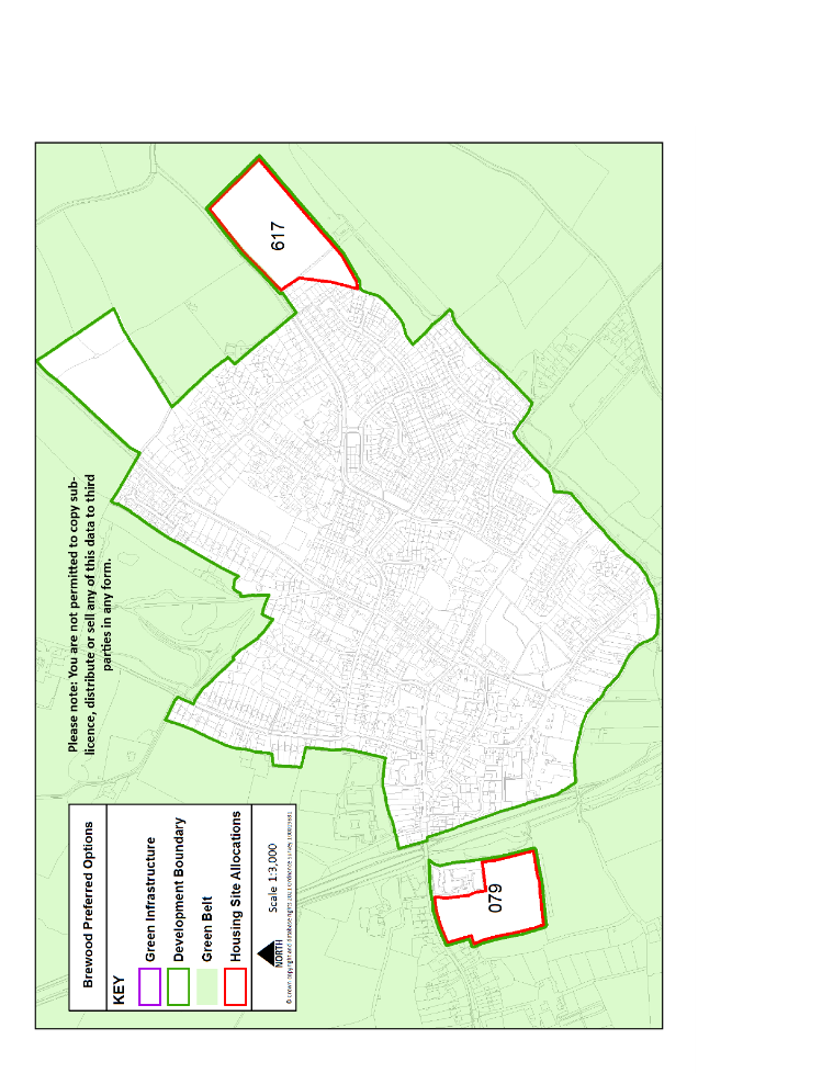
Brewood
|
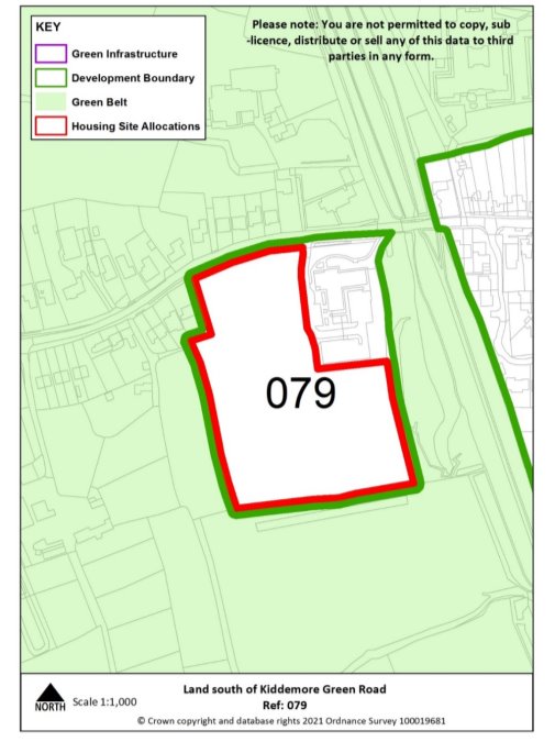
Site reference |
079 |
Village |
Brewood |
|
|
Minimum capacity |
43 dwellings |
Address |
Land south of Kiddemore Green Road |
|
|
Site area |
2.1 ha |
Proposed use |
Housing (including older persons specialist housing) |
|
|
|
||||
|
Key infrastructure requirements |
|
|||
|
Proposed access |
Provide vehicular and pedestrian access via Kiddemore Green Road, including using existing medical surgery access. |
|||
|
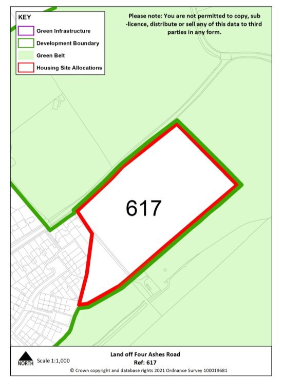
Site reference |
617 |
Village |
Brewood |
|
|
Minimum capacity |
63 dwellings |
Address |
Four Ashes Road |
|
|
Site area |
3 ha |
Proposed use |
Housing |
|
|
|
||||
|
Key infrastructure requirements |
Any relevant policy requirements including affordable housing, open space, education, health, sports and recreation, energy efficiency, climate change mitigation, flood risk mitigation, highways, sustainable transport, housing mix and green infrastructure, delivered in line with the relevant development plan policy standards. |
|||
|
Proposed access |
Provide vehicular and pedestrian access via Four Ashes Road including extension of existing footway. |
|||
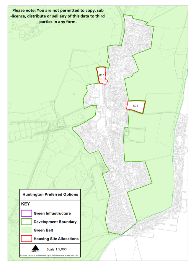
Huntington
|
Site Reference |
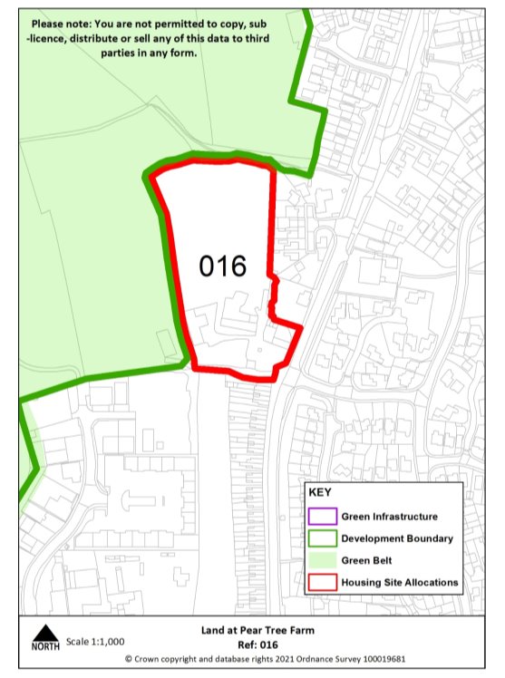
016 |
Village |
Huntington |
|
Minimum capacity |
39 |
Address |
Land at Pear Tree Farm |
|
Site area |
1.6 ha |
Proposed Use |
Housing |
|
|
|||
|
Key infrastructure requirements |
Any relevant policy requirements including affordable housing, open space, education, health, sports and recreation, energy efficiency, climate change mitigation, flood risk mitigation, highways, sustainable transport, housing mix and green infrastructure, delivered in line with the relevant development plan policy standards. |
||
|
Proposed access |
Provide vehicular and pedestrian access via Stafford Road. |
||
|
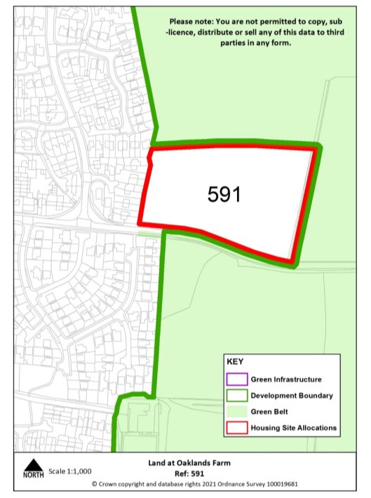
Site reference |
591 |
Village |
Huntington |
|
Minimum capacity |
44 dwellings |
Address |
Land at Oaklands Farm (north of Limepit Lane) |
|
Site area |
2.0 ha |
Proposed use |
Housing |
|
|
|||
|
Key infrastructure requirements |
Any relevant policy requirements including affordable housing, open space, education, health, sports and recreation, energy efficiency, climate change mitigation, flood risk mitigation, highways, sustainable transport, housing mix and green infrastructure, delivered in line with the relevant development plan policy standards. |
||
|
Proposed access |
Provide vehicular and pedestrian access via Limepit Lane. |
||
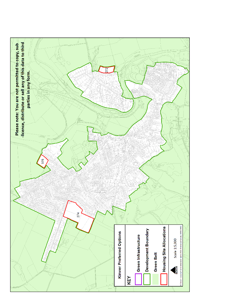
Kinver
|
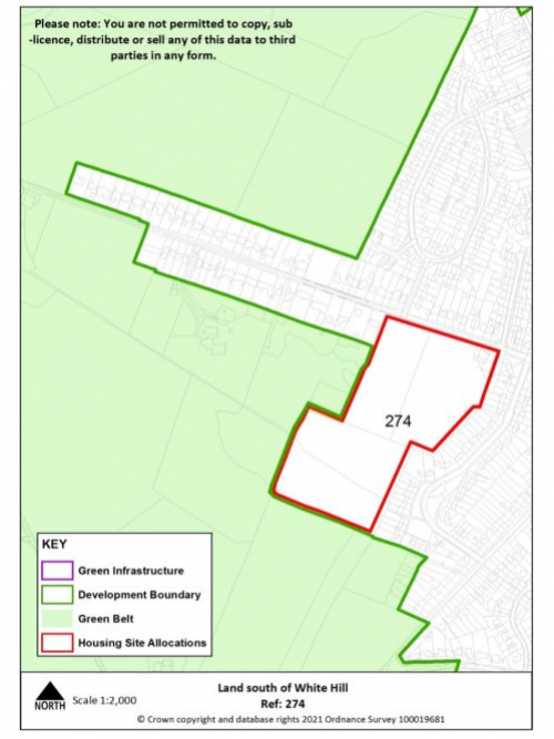
Site reference |
274 |
Village |
Kinver |
||||
|
Minimum capacity |
Up to 38 dwellings consented on allocated site (20/00621/OUT) alongside minimum 82 dwellings on safeguarded land |
Address |
Land south of White Hill |
||||
|
Site area |
5.5 ha |
Proposed use |
Housing |
||||
|
|
|||||||
|
Key infrastructure requirements |
Any relevant policy requirements including affordable housing, open space, education, health, sports and recreation, energy efficiency, climate change mitigation, flood risk mitigation, highways, sustainable transport, housing mix and green infrastructure, delivered in line with the relevant development plan policy standards. |
||||||
|
Proposed access |
Provide vehicular and pedestrian access via White Hill. |
||||||
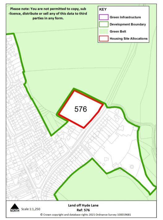
|
Site reference |
576 |
Village |
Kinver |
||||
|
Minimum capacity |
22 dwellings |
Address |
Land off Hyde Lane (west) |
||||
|
Site area |
1 ha |
Proposed Use |
Housing |
||||
|
|
|||||||
|
Key infrastructure requirements |
Any relevant policy requirements including affordable housing, open space, education, health, sports and recreation, energy efficiency, climate change mitigation, flood risk mitigation, highways, sustainable transport, housing mix and green infrastructure, delivered in line with the relevant development plan policy standards. |
||||||
|
Proposed access |
Provide vehicular and pedestrian access via Hyde Lane, including extension of existing footway. |
||||||
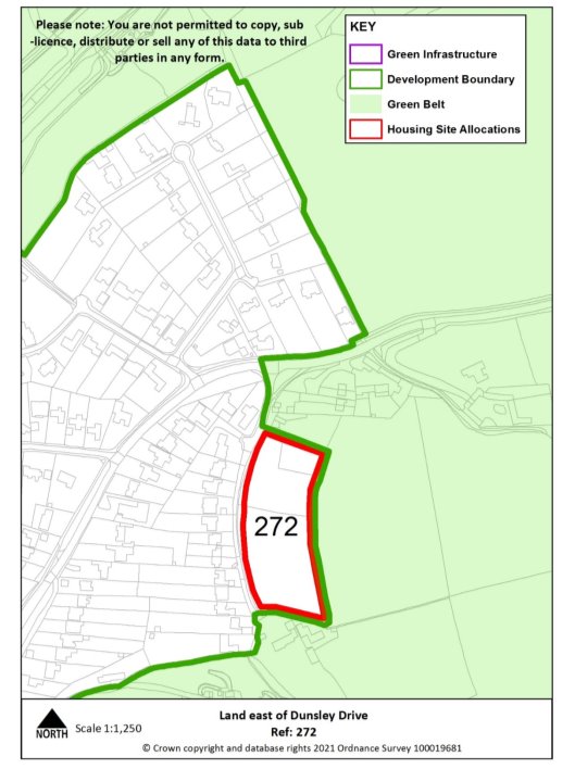
|
Site reference |
272 |
Village |
Kinver |
|
Minimum capacity |
22 dwellings |
Address |
Land east of Dunsley Drive |
|
Site area |
1 ha |
Proposed use |
Housing |
|
|
|||
|
Key infrastructure requirements |
Any relevant policy requirements including affordable housing, open space, education, health, sports and recreation, energy efficiency, climate change mitigation, flood risk mitigation, highways, sustainable transport, housing mix and green infrastructure, delivered in line with the relevant development plan policy standards. |
||
|
Proposed access |
Provide vehicular and pedestrian access to public highway. |
||
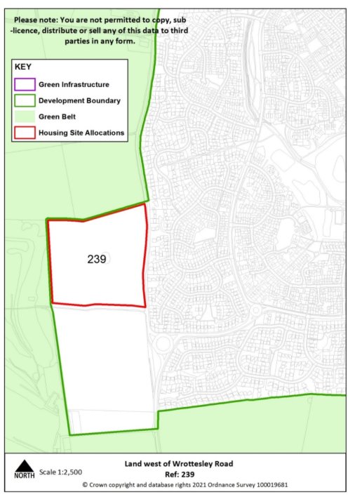
Perton
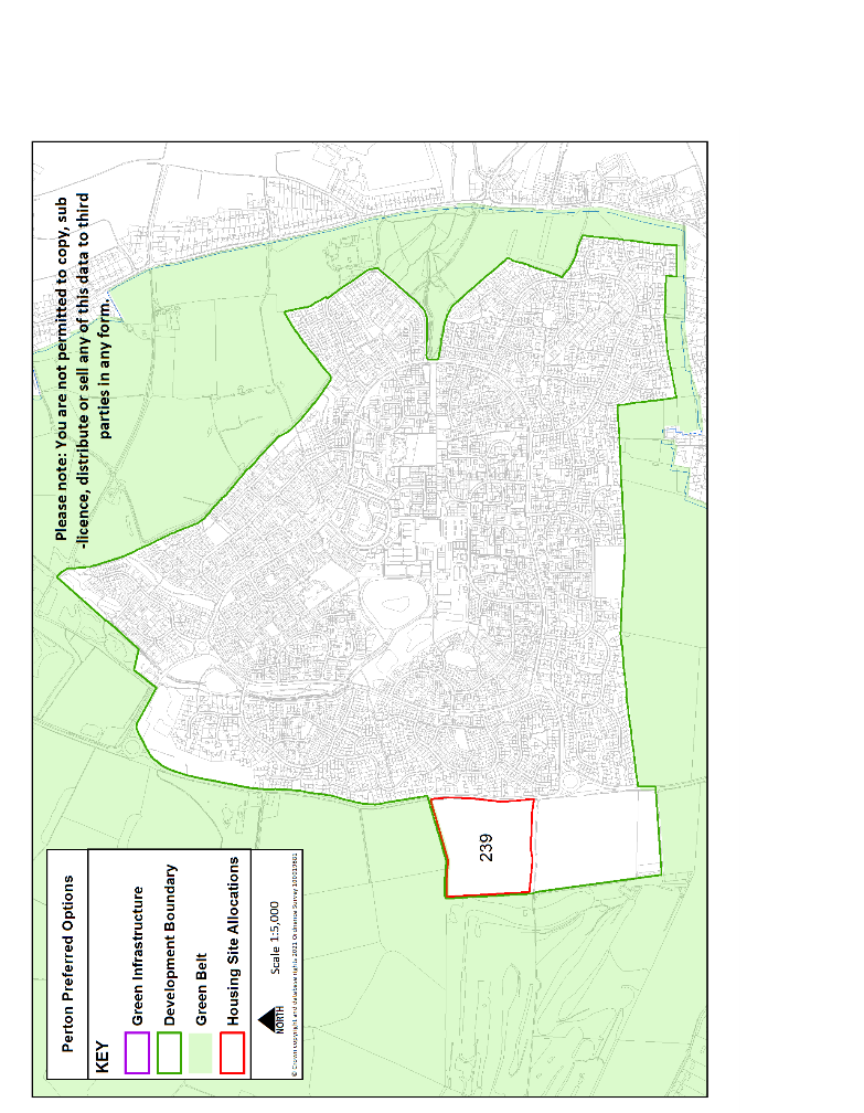
|
Site reference |
239 |
Village |
Perton |
|
Minimum capacity |
150 dwellings |
Address |
Land west of Wrottesley Park Road (south) |
|
Site area |
7.2 ha |
Proposed use |
Housing |
|
|
|||
|
Key infrastructure requirements |
Any relevant policy requirements including affordable housing, open space, education, health, sports and recreation, energy efficiency, climate change mitigation, flood risk mitigation, highways, sustainable transport, housing mix and green infrastructure, delivered in line with the relevant development plan policy standards. |
||
|
Proposed access |
Provide vehicular and pedestrian access via Wrottesley Park Road and pedestrian access into neighbouring allocated site. |
||
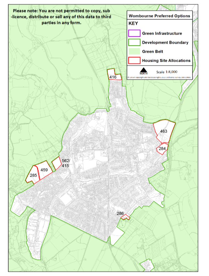
Wombourne
|
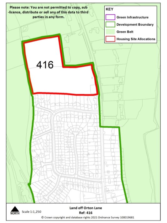
Site Reference |
416 |
Village |
Wombourne |
|
Minimum capacity |
57 dwellings |
Address |
Land off Orton Lane |
|
Site area |
2.8 |
Proposed Use |
Housing |
|
|
|||
|
Key infrastructure requirements |
Any relevant policy requirements including affordable housing, open space, education, health, sports and recreation, energy efficiency, climate change mitigation, flood risk mitigation, highways, sustainable transport, housing mix and green infrastructure, delivered in line with the relevant development plan policy standards. |
||
|
Proposed access |
Provide vehicular and pedestrian access via Orton Lane, including extension of existing footway. |
||
|
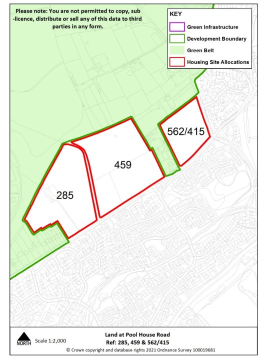
Site reference |
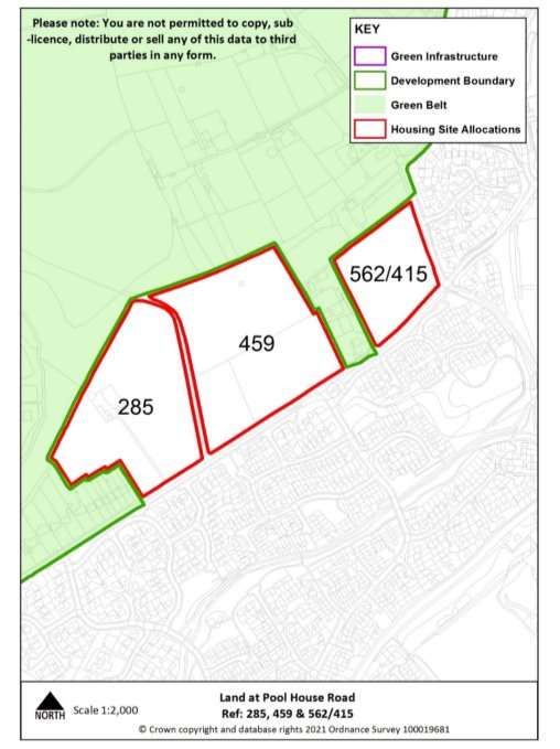
285 |
Village |
Wombourne |
|
Minimum capacity |
82 dwellings |
Address |
Land off Pool House Road |
|
Site area |
3.9 ha |
Proposed use |
Housing |
|
|
|||
|
Key infrastructure requirements |
|
||
|
Proposed access |
Provide vehicular and pedestrian access via Pool House Road alongside pedestrian links to the village centre along Ounsdale Road. |
||
|
Site reference |
562/415 |
Village |
Wombourne |
|
Minimum capacity |
44 dwellings |
Address |
Land off Pool House Road |
|
Site area |
1.9 ha |
Proposed use |
Housing |
|
|
|||
|
Key infrastructure requirements |
Any relevant policy requirements including affordable housing, open space, education, health, sports and recreation, energy efficiency, climate change mitigation, flood risk mitigation, highways, sustainable transport, housing mix and green infrastructure, delivered in line with the relevant development plan policy standards. |
||
|
Proposed access |
Provide vehicular and pedestrian access via Pool House Road alongside pedestrian links to the village centre along Ounsdale Road. |
||
|
Site reference |
459 |
Village |
Wombourne |
|
Minimum capacity |
97 dwellings |
Address |
Land off Pool House Road |
|
Site area |
4.6 ha |
Proposed use |
Housing |
|
|
|||
|
Key infrastructure requirements |
|
||
|
Proposed access |
Provide vehicular and pedestrian access via Pool House Road alongside pedestrian links to the village centre along Ounsdale Road. |
||
|
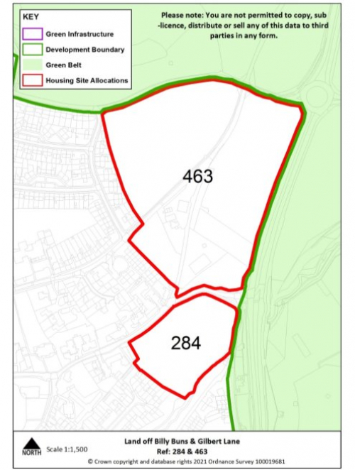
Site reference |
463 & 284 |
Village |
Wombourne |
|
Minimum capacity |
223 dwellings |
Address |
Land off Billy Buns Lane & Gilbert Lane |
|
Site area |
10.6 ha |
Proposed use |
Housing |
|
|
|||
|
Key infrastructure requirements |
Any relevant policy requirements including affordable housing, open space, education, health, sports and recreation, energy efficiency, climate change mitigation, flood risk mitigation, highways, sustainable transport, housing mix and green infrastructure, delivered in line with the relevant development plan policy standards. |
||
|
Proposed access |
Provide vehicular and pedestrian access via Billy Buns Lane, High Street and School Road, including extensions of existing footways. |
||
|
Site reference |
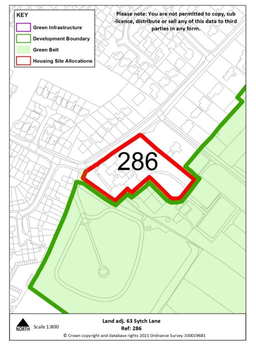
286 |
Village |
Wombourne |
|
Minimum capacity |
16 dwellings |
Address |
Land adj. 63 Sytch Lane |
|
Site area |
0.6 ha |
Proposed use |
Housing |
|
|
|||
|
Key infrastructure requirements |
Any relevant policy requirements including affordable housing, open space, education, health, sports and recreation, energy efficiency, climate change mitigation, flood risk mitigation, highways, sustainable transport, housing mix and green infrastructure, delivered in line with the relevant development plan policy standards. |
||
|
Proposed access |
Provide vehicular and pedestrian access via Sytch Lane. |
||
Coven

|
Site reference |
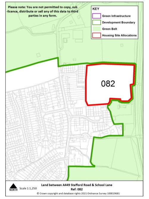
082 |
Village |
Coven |
|
Minimum capacity |
48 dwellings |
Address |
Land between A449 Stafford Road & School Lane |
|
Site area |
2.3 ha |
Proposed use |
Housing |
|
|
|||
|
Key infrastructure requirements |
Any relevant policy requirements including affordable housing, open space, education, health, sports and recreation, energy efficiency, climate change mitigation, flood risk mitigation, highways, sustainable transport, housing mix and green infrastructure, delivered in line with the relevant development plan policy standards. |
||
|
Proposed access |
Provide vehicular and pedestrian access via the playing fields of School Lane. |
||
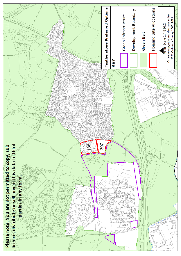
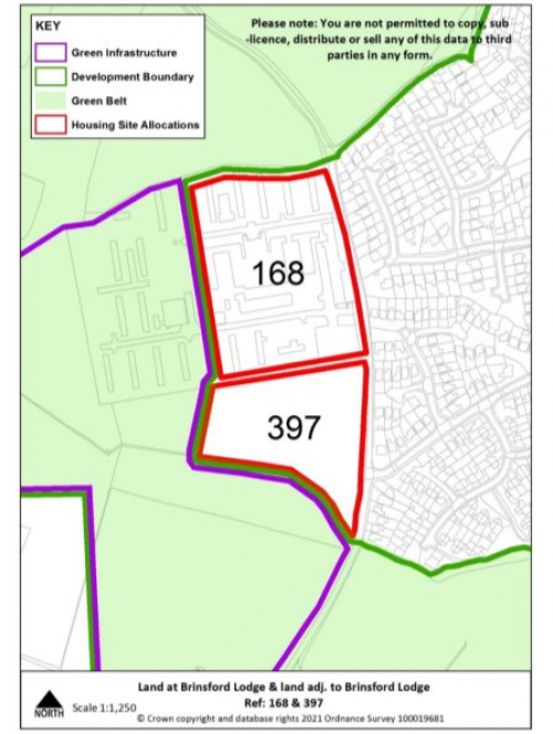
Featherstone
|
Site reference |
168 |
Village |
Featherstone |
|
Capacity |
Planning permission to deliver 81 dwellings (19/00919/FUL) |
Address |
Land at Brinsford Lodge |
|
Site area |
2.8 ha |
Proposed use |
Housing |
|
|
|||
|
Key infrastructure requirements |
|
||
|
Proposed access |
Provide vehicular and pedestrian access via Malayan Way and into adjacent safeguarded land, with pedestrian access to green infrastructure to the west. |
||
|
Site Reference |
397 |
Village |
Featherstone |
|
Minimum capacity |
39 dwellings |
Address |
Land adj. to Brinsford Lodge, Brookhouse Lane |
|
Site area |
1.6 ha |
Proposed Use |
Housing |
|
|
|||
|
Key infrastructure requirements |
Any relevant policy requirements including affordable housing, open space, education, health, sports and recreation, energy efficiency, climate change mitigation, flood risk mitigation, highways, sustainable transport, housing mix and green infrastructure, delivered in line with the relevant development plan policy standards. |
||
|
Proposed access |
Provide vehicular and pedestrian access via Malayan Way and into allocated site to the north. |
||
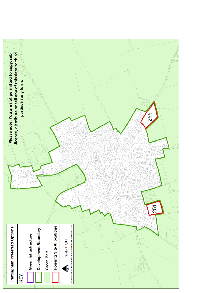
Pattingham
|
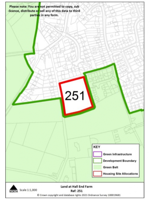
Site Reference |
251 |
Village |
Pattingham |
|
Minimum capacity |
17 dwellings |
Address |
Hall End Farm |
|
Site area |
0.8 ha |
Proposed Use |
Housing |
|
|
|||
|
Key infrastructure requirements |
Any relevant development plan policy requirements including affordable housing, open space, education, health, sports and recreation, energy efficiency, climate change mitigation, flood risk mitigation, highways, sustainable transport, housing mix and green infrastructure, delivered in line with the relevant development plan policy standards. |
||
|
Proposed access |
Provide vehicular and pedestrian access to public highway via the adjacent rural exception site to the east |
||
|
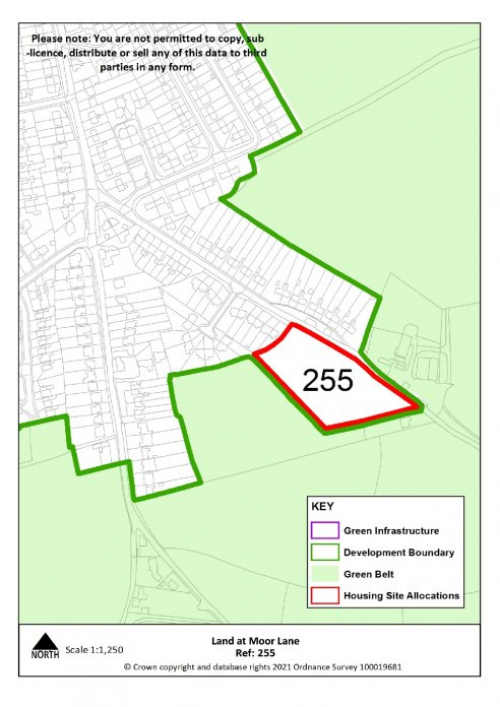
Site Reference |
255 |
Village |
Pattingham |
|
Minimum capacity |
22 dwellings |
Address |
Land at Moor Lane |
|
Site area |
1 ha |
Proposed Use |
Housing |
|
|
|||
|
Key infrastructure requirements |
Any relevant development plan policy requirements including affordable housing, open space, education, health, sports and recreation, energy efficiency, climate change mitigation, flood risk mitigation, highways, sustainable transport, housing mix and green infrastructure, delivered in line with the relevant development plan policy standards. |
||
|
Proposed access |
Provide vehicular and pedestrian access via Moor Lane, including new footway fronting the site off Moor Lane. |
||
Swindon
|
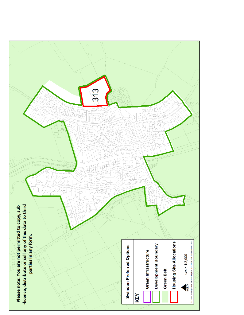
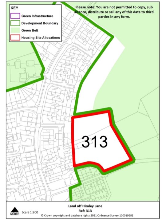
Site Reference |
313 |
Village |
Swindon |
|
Minimum capacity |
22 dwellings |
Address |
Land off Himley Lane |
|
Site area |
1 ha |
Proposed Use |
Housing |
|
|
|||
|
Key infrastructure requirements |
Any relevant development plan policy requirements including affordable housing, open space, education, health, sports and recreation, energy efficiency, climate change mitigation, flood risk mitigation, highways, sustainable transport, housing mix and green infrastructure, delivered in line with the relevant development plan policy standards. |
||
|
Proposed access |
Provide vehicular and pedestrian access via Himley Lane, including footway link to wider village. |
||
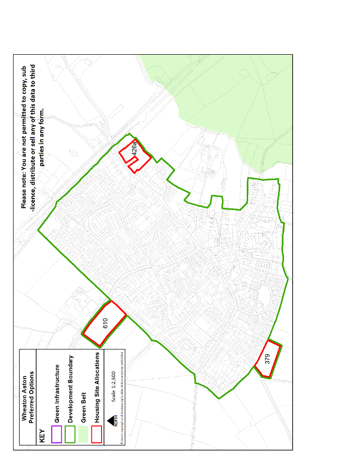
Wheaton Aston
|
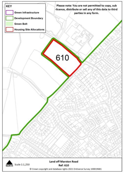
Site reference |
610 |
Village |
Wheaton Aston |
|
Minimum capacity |
22 dwellings |
Address |
Land off Marston Road/Fenton House Lane |
|
Site area |
1 ha |
Proposed use |
Housing |
|
|
|||
|
Key infrastructure requirements |
Any relevant policy requirements including affordable housing, open space, education, health, sports and recreation, energy efficiency, climate change mitigation, flood risk mitigation, highways, sustainable transport, housing mix and green infrastructure, delivered in line with the relevant development plan policy standards. |
||
|
Proposed access |
Provide vehicular and pedestrian access via Fenton House Lane/Marston Road |
||
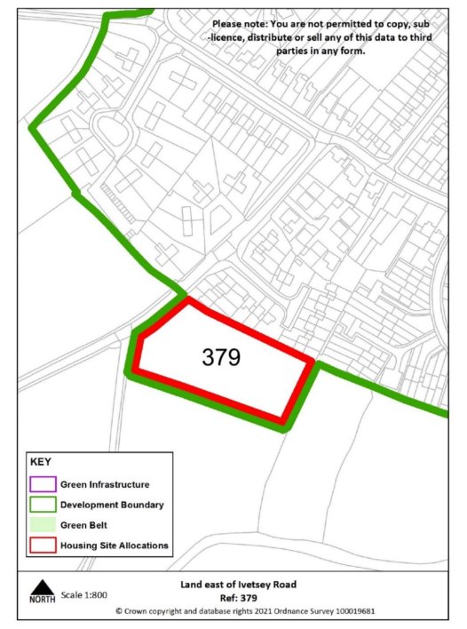
|
Site reference |
379 |
Village |
Wheaton Aston |
|
Minimum capacity |
18 dwellings |
Address |
Land off Ivetsey Road |
|
Site area |
0.8 ha |
Proposed use |
Housing |
|
|
|||
|
Key infrastructure requirements |
Any relevant policy requirements including affordable housing, open space, education, health, sports and recreation, energy efficiency, climate change mitigation, flood risk mitigation, highways, sustainable transport, housing mix and green infrastructure, delivered in line with the relevant development plan policy standards. |
||
|
Proposed access |
Provide vehicular and pedestrian access via Ivetsey Road, including extension of existing footway. |
||
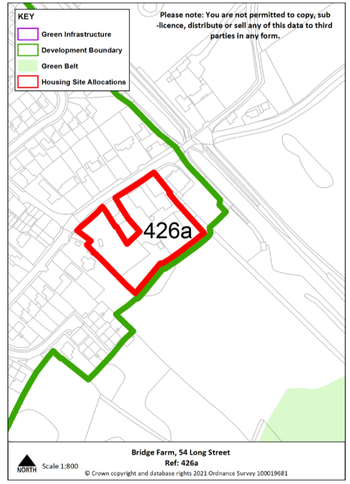
|
Site reference |
426a |
Village |
Wheaton Aston |
|
Minimum capacity |
15 dwellings |
Address |
Bridge Farm: 54 Long Street |
|
Site area |
0.6 ha |
Proposed use |
Housing |
|
|
|||
|
Key infrastructure requirements |
Any relevant development plan policy requirements including affordable housing, open space, education, health, sports and recreation, energy efficiency, climate change mitigation, flood risk mitigation, highways, sustainable transport, housing mix and green infrastructure, delivered in line with the relevant development plan policy standards. |
||
|
Proposed access |
Provide vehicular and pedestrian access via Long Street. |
||
Urban Extensions to Neighbouring Towns and Cities
South of Stafford
|
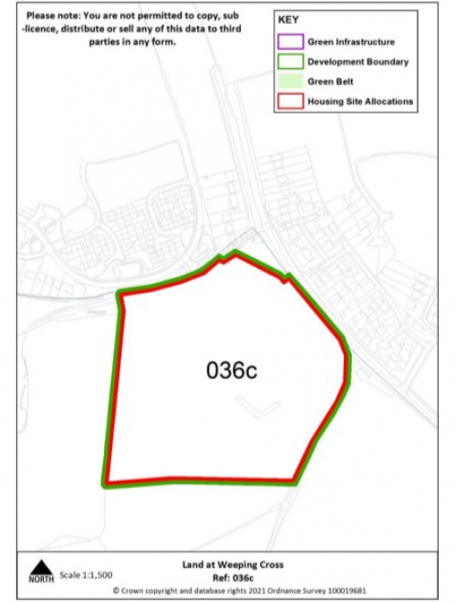
Site reference |
036c |
Village |
South of Stafford |
|
Minimum capacity |
168 dwellings |
Address |
Land at Weeping Cross (adjoining Stafford Borough boundary) |
|
Site area |
8 ha |
Proposed use |
Housing |
|
|
|||
|
Site infrastructure requirements |
Any relevant policy requirements including affordable housing, open space, education, health, sports and recreation, energy efficiency, climate change mitigation, flood risk mitigation, highways, sustainable transport, housing mix and green infrastructure, delivered in line with the relevant development plan policy standards. |
||
|
Proposed access |
Provide vehicular and pedestrian access via Cannock Road (A34). |
||
West of Wolverhampton
|
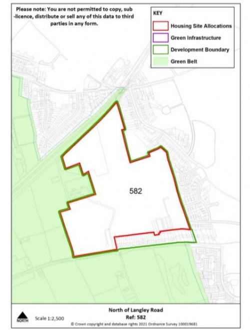
Site reference |
582 |
Village |
West of Wolverhampton |
|
Minimum capacity |
390 dwellings |
Address |
North of Langley Road (adjoining City of Wolverhampton boundary) |
|
Site size |
18.6 ha |
Proposed use |
Housing |
|
|
|||
|
Site infrastructure requirements |
Any other relevant policy requirements including affordable housing, open space, education, health, sports and recreation, energy efficiency, climate change mitigation, flood risk mitigation, highways, sustainable transport, housing mix and green infrastructure, delivered in line with the relevant development plan policy standards. |
||
|
Proposed access |
Provide vehicular and pedestrian access via Langley Road and Bellencroft Gardens. Explore potential for direct pedestrian links north to Castlecroft Road and onto adjacent railway walk. |
||