Preferred Options November 2021
5. Site Allocations
Housing
5.1 Following consultation on the Spatial Housing Strategy and Infrastructure Delivery (SHSID) consultation in October 2019, site assessments were undertaken using the site assessment criteria consulted on in Appendix 6 of the SHSID. All sites at tier 1-4 settlements and other locations identified in the Council's preferred spatial option for growth (Option G) were assessed.
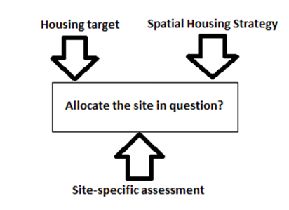
5.2 Following assessment of sites, the results of these, alongside responses to the SHSID, were considered together to determine where amendments to the preferred spatial strategy were justified (see paragraph 4.14). The process involved considering which sites to allocate in order to deliver the proposed housing target of 8,881 dwellings between 2018 and 2038. This entailed considering a balance of top-down strategic factors and bottom-up site-specific factors, which are shown in the diagram below:
5.3 The full methodology, factors considered, and results of the site assessment process for all site options can be found in our Housing Site Assessment Topic Paper.
5.4 The site selection process has identified proposed sites to meet our revised Infrastructure led strategy between 2018-38, ensuring enough housing land is identified to meet the Council's housing target of 8,881 dwellings between 2018 and 2038, whilst providing extra land to ensure the plan is flexible to changing circumstances. Where possible, the likely infrastructure requirements for both large scale and smaller housing sites have been identified. These are set out in Policies SA1-SA4 and Appendix B for the District's largest site proposals, and in Policy SA5 and Appendix C for the small to medium sized site proposals. Further details on the delivery of these infrastructure items (e.g estimated costs, where known) are set out in the Infrastructure Delivery Plan (2021)
5.5 Further work will need to be done with infrastructure providers following this consultation to confirm these infrastructure requirements, alongside additional viability work. This will include preparing site specific viability assessment of sites with more non-standard infrastructure requirements than are currently reflected in the standard site typologies tested in the Local Plan Viability Study 2021. Following this, site specific infrastructure requirements will be refined (and more detail added where appropriate) for the Publication version of the Local Plan.
Strategic Masterplanning Locations
5.6 The new Local Plan will have a stronger focus on design than the current Local Plan reflecting a desire to create beautiful places. The plan will have stronger design policies for all sites and will commit to site specific Supplementary Planning Documents (SPDs) for the four strategic housing allocations. These SPDs will be finalised following adoption of the plan, setting out a masterplan and associated design codes for these sites whilst sustainably managing the delivery of infrastructure on each site to ensure that infrastructure is provided at the right stage in a site's development. It is proposed that the process for masterplanning these sites will be guided by community engagement, in line with the approach advocated by the Government's national model design code that puts communities at the heart of determining locally popular design. To deliver this, policies SA1-SA4 set out the policy framework for how the sites will come forward.
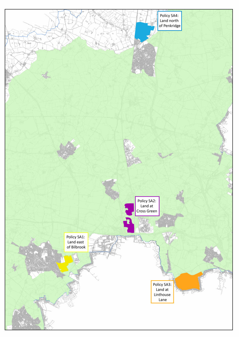
Policy SA1 – Strategic development location: Land East of Bilbrook
A strategic site for major housing growth is identified at Land East of Bilbrook, in the location shown in Appendix B of this document. By the end of the plan period, development in this location will deliver a minimum of 848 homes and a new neighbourhood that will integrate into the wider village community whilst delivering a new school for the locality. It will provide new residents with high quality connections to the existing facilities at Bilbrook and Codsall, access to leisure and recreation including along the adjacent canal towpath and sustainable access to the regionally important strategic employment site at i54 South Staffordshire and the higher order services and employment opportunities in Wolverhampton.
The release and phasing of Land East of Bilbrook will be informed by a Supplementary Planning Document (SPD) which will include an Infrastructure Delivery Strategy for the site. The development of this area will be in accordance with a masterplan and design code which will be approved as an SPD and will cover the whole of the area indicated in the relevant proforma of Appendix B.
The purpose of the Land East of Bilbrook SPD will be as follows:
- To provide more detail on how and when the strategic requirements set out in this policy will be delivered;
- To set a framework to guide the preparation of future planning applications;
- To provide a framework against which future planning applications will be assessed; and
- To enable and support the co-ordination and timely delivery of infrastructure provision
To support the housing development, it is anticipated that the Land East of Bilbrook SPD will address the delivery of the following key infrastructure and design requirements, alongside other development plan policies relevant to the site:
- A new first school to serve the needs of the Codsall and Bilbrook first school catchment, phased to ensure the timely delivery of the facility alongside other planned housing growth around the villages
- On-site retail facilities of an appropriate scale to meet the needs of the development whilst maintaining the vitality of existing centres in the adjacent village
- High quality on-site open space, green infrastructure which integrates the scheme into the existing housing recently permitted off Pendeford Mill Lane, alongside measures to ensure biodiversity net gain is achieved
- Additional off-site compensatory green infrastructure in the Green Belt to the south of the site (as indicated in Appendix B of this document)
- Highways, sustainable transport and active travel infrastructure, including links to infrastructure in the wider area and the provision of a link road between Pendeford Mill Lane, Barnhurst Lane and Lane Green Road
To enable a comprehensive and coordinated development approach, piecemeal or unplanned development proposals within the area which are likely to prejudice its delivery including the infrastructure required for the area will not be permitted. To ensure that Land East of Bilbrook is deliverable when required, the SPD will be adopted in the early years of the plan period.
Policy SA2 – Strategic development location: Land at Cross Green
A strategic site for major housing growth is identified at Land at Cross Green, in the location shown in Appendix B of this document. By the end of the plan period, development in this location will deliver a minimum of 1200 homes and a new community on a key transport corridor with excellent ties to regionally important employment sites at i54 South Staffordshire and ROF Featherstone and the services and facilities in the Black Country. This will deliver a new primary school and village centre alongside land to assist in the delivery of a new parkway to serve new and existing residents in the surrounding area.
The release and phasing of Land at Cross Green will be informed by a Supplementary Planning Document (SPD) which will include an Infrastructure Delivery Strategy for the site. The development of this area will be in accordance with a masterplan and design code which will be approved as an SPD and will cover the whole of the area indicated in the relevant proforma of Appendix B.
The purpose of the Land at Cross Green SPD will be as follows:
- To provide more detail on how and when the strategic requirements set out in this policy will be delivered;
- To set a framework to guide the preparation of future planning applications;
- To provide a framework against which future planning applications will be assessed; and
- To enable and support the co-ordination and timely delivery of infrastructure provision
To support the housing development, it is anticipated that the Land at Cross Green SPD will address the delivery of the following key infrastructure and design requirements, alongside other development plan policies relevant to the site:
- Safeguarded land to support a potential rail-based parkway along the West Coast Mainline
- On-site retail, primary education and any necessary community facilities of an appropriate scale to meet the needs of the development whilst maintaining the vitality of services and facilities in the wider area
- High quality on-site open space, green infrastructure and measures to ensure biodiversity net gain is achieved
- Additional off-site compensatory green infrastructure in the Green Belt running through the site (as indicated in Appendix B of this document)
- Highways, sustainable transport and active travel infrastructure, which will include links to infrastructure in the wider area and will align as far as possible with sustainable transport and active travel improvements proposed in the City of Wolverhampton to the south
- Delivering a layout that appropriately integrates the proposed link road between the A449 and ROF Featherstone, whilst also ensuring the development can be distinguished from the existing community at Cross Green
To enable a comprehensive and coordinated development approach, piecemeal or unplanned development proposals within the area which are likely to prejudice its delivery including the infrastructure required for the area will not be permitted. To ensure that Land at Cross Green is deliverable when required, the SPD will be adopted in the early years of the plan period.
Policy SA3 – Strategic development location: Land North of Linthouse Lane
A strategic site for major housing growth is identified at Land North of Linthouse Lane in the location shown in Appendix B of this document. By the end of the plan period, development in this location will deliver a minimum of 1200 homes[10] and an on-site primary school, local centre and new neighbourhoods that are well connected to the Black Country urban area, giving new residents good access to the higher order services and employment opportunities in the adjacent towns and cities.
The release and phasing of Land North of Linthouse Lane will be informed by a Supplementary Planning Document (SPD) which will include an Infrastructure Delivery Strategy for the site. The development of this area will be in accordance with a masterplan and design code which will be approved as an SPD and will cover the whole of the area indicated in the relevant proforma of Appendix B.
The purpose of the Land North of Linthouse Lane SPD will be as follows:
- To provide more detail on how and when the strategic requirements set out in this policy will be delivered;
- To set a framework to guide the preparation of future planning applications;
- To provide a framework against which future planning applications will be assessed; and
- To enable and support the co-ordination and timely delivery of infrastructure provision
To support the housing development, it is anticipated that the Land North of Linthouse Lane SPD will address the delivery of the following key infrastructure and design requirements, alongside other development plan policies relevant to the site:
- On-site retail, primary education and any necessary community facilities of an appropriate scale to meet the needs of the development whilst maintaining the vitality of services and facilities in the wider area
- On-site open space, green infrastructure and measures to ensure biodiversity net gain is achieved, including the provision of additional off-site compensatory green infrastructure in the Green Belt to the north-east of the site (as indicated in Appendix B of this document)
- Highways, sustainable transport and active travel infrastructure, which will include links to infrastructure in the wider area and will align as far as possible with sustainable transport and active travel improvements proposed in the City of Wolverhampton to the south
To enable a comprehensive and coordinated development approach, piecemeal or unplanned development proposals within the area which are likely to prejudice its delivery including the infrastructure required for the area will not be permitted. To ensure that Land North of Linthouse Lane is deliverable when required, the SPD will be adopted in the early years of the plan period.
Policy SA4 – Strategic development location: Land North of Penkridge
A strategic site for major housing growth is identified at Land North of Penkridge in the location shown in Appendix B of this document. By the end of the plan period, development in this location will provide a new neighbourhood where residents can easily meet their day-to-day needs using facilities within the development or Penkridge village. The scheme will be designed to be integrated into the wider village community and will include a new first school, whilst providing a sympathetic edge to the adjoining countryside to the North and the River Penk.
The release and phasing of Land North of Penkridge will be informed by a Supplementary Planning Document (SPD) which will include an Infrastructure Delivery Strategy for the site. The development of this area will be in accordance with a masterplan and design code which will be approved as an SPD and will cover the whole of the area indicated in the relevant proforma of Appendix B.
The purpose of the Land North of Penkridge SPD will be as follows:
- To provide more detail on how and when the strategic requirements set out in this policy will be delivered;
- To set a framework to guide the preparation of future planning applications;
- To provide a framework against which future planning applications will be assessed; and
- To enable and support the co-ordination and timely delivery of infrastructure provision
To support the housing development, it is anticipated that the Land North of Penkridge SPD will address the delivery of the following key infrastructure and design requirements, alongside other development plan policies relevant to the site:
- An on-site first school, retail and any necessary community facilities of an appropriate scale to meet the needs of the development whilst maintaining the vitality of services and facilities in the wider area
- High quality on-site open space, green infrastructure which integrates into existing housing permitted to the south of the site, alongside measures to ensure biodiversity net gain is achieved
- Highways, sustainable transport and active travel infrastructure, including links to infrastructure in the wider area
- Layout and design to enhance the entrance into the village, to protect the setting of the River Penk as it runs through Penkridge and to integrate into the wider landscape from the AONB to the east
- Improvements to local leisure facilities in the wider village
- Provision of a new riverside country park adjacent to the River Penk (as indicated in Appendix B of this document)
To enable a comprehensive and coordinated development approach, piecemeal or unplanned development proposals within the area which are likely to prejudice its delivery including the infrastructure required for the area will not be permitted. To ensure that Land North of Penkridge is deliverable when required, the SPD will be adopted in the early years of the plan period.
(386) Question 7:
- Do you support the proposed strategic housing allocations in policies SA1-SA4? Yes/No
If no, please explain your reasons for this.
- Do you agree that given the scale of the 4 sites detailed in policies SA1-SA4, these warrant their own policy to set the vision for the site, alongside a requirement for a detailed masterplan and design code? Yes/No
Housing Allocations
5.7 Housing allocations to deliver growth over the plan period in accordance with the Council's Spatial Strategy (Policy DS3) are set out in policy SA5 below. Details of the methodology for filtering site options and the assessments of allocated sites and reasonable alternatives can be found in the accompanying Housing Site Assessment Topic Paper.
|
SA5: Housing Allocations Alongside the strategic development locations identified in Policies SA1, SA2, SA3 and SA4, the following housing allocations will be delivered to meet the district's housing target up to 2038. The site boundaries are set out in the relevant site proforma in Appendix C.
All site allocations will be delivered in accordance with the individual site planning requirements set out in Appendix C and any other mitigation which is deemed necessary, through the development management process. Proposals should be consistent with other Development Management policies in the Local Plan. |
||||||||||||||||||||||||||||||||||||||||||||||||||||||||||||||||||||||||||||||||||||||||||||||||||||||||||||||||||||||||||||||||||||||||||||||||||||||||||||||||||||||||||||||||||||||||||||||||||||||||||||||||||||||||||||||||||||||||||||||||
(1571) Question 8:
Do you support the proposed housing allocations in Policy SA5? Yes/No
Please reference the site reference number (e.g site 582) for the site you are commenting on in your response.
Gypsy and Travellers
5.8 As detailed in Chapter 4, the strategy for new Gypsy, Traveller and Travelling Showperson provision is to meet the needs of existing families that meet Planning Policy for Travellers Sites (PPTS) planning definition, as identified by the GTAA 2021 by continuing to deliver privately owned sites/pitches. The evidence supports an approach therefore of looking to allocate existing temporary or unauthorised sites to permanent (subject to other planning considerations) and looking to intensify and extend existing sites, rather than allocating wholly new sites that may have been suggested by non-travellers. It is currently not possible to test an alternative strategy of dispersing new pitch allocations more widely across the district due to a lack of site options, however we welcome views on whether there are any alternative approaches that have not been considered.
5.9 The GTAA identified a need for 121 pitches over the plan period for those families that meet the planning definition of Gypsies and Travellers. Where possible, the Local Plan proposes to allocate pitches to meet our families 5 year need, as reflected in the GTAA 2021 and Pitch Deliverability Study 2021. Future pitch provision beyond the 5 year requirement (including Travelling Showperson needs) will come through the Development Management process with proposals considered against a criteria based policy (see Chapter 6 – Policy HC8). Policy HC8 and any other relevant policies (e.g. DS1: Green Belt) will also be the mechanism through the Development Management process for considering those families/individuals with an identified need but do not meet the planning definition of a Gypsy, Traveller or Travelling Snowperson. A need of 24 pitches over the plan period for those not meeting the planning definition was identified in the GTAA 2021.
5.10 Proposed allocations are informed by the Council's Pitch Deliverability Study 2021 that identifies family need, engages with families to explore what options they have, including amendments to site layout. Due to site constraints identified in the study, the current 5 year need (72 pitches) for families that meet the planning definition could not be met on all existing sites. The assessment identifies 42 deliverable pitch options which we propose to allocate. The red line boundaries of the sites have been informed by an assessment of capacity considering site licencing requirements and the land needed for access/turning and amenity buildings. Proposed allocations are set out below:
|
SA6: Gypsy and Traveller Allocations Gypsy and Traveller pitches are allocated at the locations set out in the table below to meet identified family needs. The new pitch allocations must be located within the red line boundary of the site as shown in Appendix D.
All sites are existing established sites or direct extensions to these and are often in remote rural locations and washed over by the West Midlands Green Belt. As an exception to the planning policies relating to the location of Gypsy and Traveller pitch provision in the Green Belt, pitches identified in the Green Belt through the Local Plan will be acceptable in principle where planning applications are submitted for the specified number of additional pitches allocated in the Local Plan. Planning applications on these sites will need to be in accordance with the criteria in Policy HC8, any site-specific planning requirements set out in Appendix D, and any other mitigation which is deemed necessary through the development management process. Proposals should be consistent with other Development Management policies in the Local Plan. |
(60) Question 9:
- Do you support the proposed pitch allocations in Policy SA6?Yes/No
Please reference the site reference number (e.g GT01) for the site you are commenting on in your response.
- Is there another option for meeting our gypsy and traveller needs, including any alternative site suggestions that could be considered? Yes/No
Please provide details, including a plan for new site suggestions
Employment
5.11 Employment land should be identified to meet the needs of all employment uses; offices, research and development, light/general industrial, and storage/distribution. The level of employment sites and premises required to meet South Staffordshire requirements over the plan period was calculated in the Council's Economic Development Needs Assessment (EDNA) 2018 and identified a demand for the district between 67-86ha.
5.12 Assuming the higher demand figure, the supply of employment land over the plan period is sufficient to meet this. The district's main employment areas are set out in Table 9 below which details and the amount of employment land available for the period 2018-2038 on a site specific basis:
|
|
Site Name |
Parish(es) |
Site Area (Ha) |
Available Land for Employment Development 2018-2038 |
|
Strategic Site |
Four Ashes Industrial Estate, Four Ashes (inc. Bericote). |
Penkridge. Brewood & Coven |
72 |
10.58ha |
|
Hilton Cross Business Park. |
Featherstone |
18 |
4.84ha |
|
|
ROF Featherstone. |
Featherstone |
36 |
36ha |
|
|
West Midlands Interchange. |
Penkridge. Brewood & Coven |
297 |
232.5ha (excluding green infrastructure) |
|
|
i54, Wobaston Road. |
Bilbrook |
90.5 |
6.12ha |
|
|
I54 Western Extension |
Bilbrook |
40 |
40ha |
|
|
Acton Gate. |
Dunston |
13.7 |
- |
|
|
Acton Plaza. |
Dunston |
0.8 |
0.8ha |
|
|
Balliol Business Park, Wobaston Road. |
Bilbrook |
6.6 |
- |
|
|
Coppice Lane, Cheslyn Hay. |
Cheslyn Hay |
7.3 |
- |
|
|
Dunston Business Village. |
Dunston |
2.1 |
- |
|
|
Essington Light Industrial Estate, Bognop Road. |
Essington |
0.8 |
- |
|
|
Hawkins Drive Industrial Estate. |
Cheslyn Hay |
12 |
0.25ha |
|
|
Hepworth Site, Warstones Road. |
Essington |
3.8 |
- |
|
|
Heathmill Road Industrial Estate. |
Wombourne |
19.3 |
- |
|
|
Hilton Main Industrial Estate |
Featherstone |
7.07 |
||
|
Vernon Park |
Featherstone |
5.7 |
2.8ha |
|
|
Hobnock Road, Essington. |
Essington |
5.2 |
5.2ha |
|
|
Huntington Industrial Estate. |
Huntington |
1.1 |
- |
|
|
Kingswood Business Park. |
Perton |
1.0 |
- |
|
|
Landywood Enterprise Park |
Great Wyrley |
3.4 |
- |
|
|
Landywood Lane Industrial Estate. |
Cheslyn Hay |
6.5 |
- |
|
|
Little Business Park, Littleton Drive. |
Huntington |
2.7 |
- |
|
|
Loades plc., Gorsey Lane. |
Great Wyrley |
1.1 |
- |
|
|
Ounsdale Road Industrial Estate. |
Wombourne |
2 |
0.9ha |
|
|
Owens Trading Estate, Wobaston Road. |
Bilbrook |
7.1 |
- |
|
|
Paradise Lane, Slade Heath. |
Featherstone |
3.1 |
- |
|
|
Former Sandvik Site, Brinsford |
Featherstone |
2.2 |
- |
|
|
Smestow Bridge Industrial Estate. |
Wombourne |
21.1 |
- |
|
|
Wolverhampton Business Airport. |
Bobbington |
1.7 |
- |
|
|
Wombourne Enterprise Park. |
Wombourne |
3.9 |
- |
|
|
TOTAL |
340ha |
Table 9: South Staffordshire Employment stock
5.13 Table 9 uses 2018 as a base date as this is the start of the plan period and the year that the need was assessed in the EDNA. As such, this reflects available employment land from 2018 up to 2038, however some of the available land may now be developed or is being developed. The figures includes new employment land that has become available since 2018, which is limited to West Midlands Interchange (WMI). The figure for the available land at WMI reflects the proposed built area minus the area set aside for green infrastructure.
5.14 WMI already has consent through the Development Consent Order (DCO) process and was assessed through our EDNA Part 2: Economic Land Availability Assessment and Employment Site Assessment Topic Paper, confirming it's suitability. Given this, and the unmet needs within the wider FEMA, it is considered that the exceptional circumstances for the release of the site from the Green Belt exist. It is therefore proposed that WMI is allocated and removed from the Green Belt, with it anticipated that it is built out by the end of the plan period.
5.15 Allocating WMI helps strengthen the portfolio of employment land in the district over the plan period, including a mix of land for strategic warehousing (WMI), advanced manufacturing (i54) and general high quality employment (ROF Featherstone). These are balanced by land for smaller scale employment opportunities (Hilton Cross) and further complemented by smaller scale employment land availability in the wider FEMA. The Council will continue to work positively with the developers on WMI to ensure the site come forward in accordance with the DCO and delivers the best scheme possible.
Policy SA7 - Employment Allocation – West Midlands Interchange
A total of 297Ha of additional land is allocated for employment development, alongside associated landscaping and strategic green infrastructure within the District's administrative area. This total is covered by a single site only at West Midlands Interchange (WMI) as specified below, together with details of the type of employment development that will be promoted upon the site.
|
Site Reference |
Site Name |
Parish |
Area (Ha) |
Employment Type (Use Class1) |
|
E33 |
West Midlands Interchange (WMI). |
Penkridge. Brewood & Coven |
297 |
B8 |
1 As defined by the Town and Country Planning (Use Classes) Order 1987 (as amended).
WMI employment site allocation is for a Strategic Rail Freight Interchange (SRFI) and will be progressed in-line with the Development Consent Order (DCO) that granted permission on 4 May 2020.
In order to meet the employment land development needs of the District, the land benefiting from the approved DCO at WMI will be removed from the Green Belt. This excludes the land specified for Green Infrastructure provision in the DCO adjacent the Canal Conservation Area and the country park to the south of Vicarage Road which will remain as Green Belt to provide compensatory improvements for the land removed for development. This is indicated on the Policies Map in Appendix E and will see 232.5ha of land removed from the Green Belt.
(74) Question 10:
Do you support the proposed allocation in Policy SA7? Yes/No
[10] Site estimated to deliver 1976 homes in total with continued delivery beyond the plan period


