Preferred Options November 2021
Appendix B
Strategic masterplanning location proformas
|
Site reference |
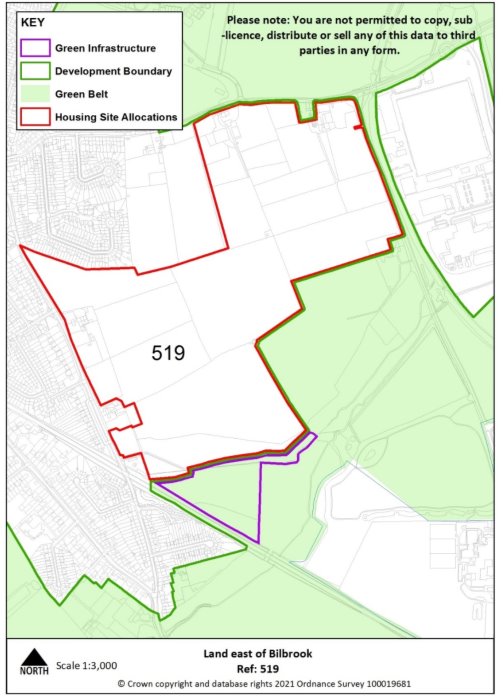
519 |
Village |
Bilbrook |
|
|
Minimum capacity |
848 dwellings |
Address |
Land east of Bilbrook |
|
|
Site area |
39.6 ha |
Proposed use |
Housing-led mixed use |
|
|
|
||||
|
Site infrastructure and access requirements |
To deliver site in accordance with site specific requirements, Supplementary Planning Document and masterplanning process set out in Policy SA1. |
|||
|
Site reference |
486c |
Location |
North of the Black Country |
|
|
Minimum capacity |
1976 dwellings (1200 dwellings by 2038) |
Address |
Land at Linthouse Lane (Essington Ward - adjoining City of Wolverhampton Boundary) |
|
|
Site area |
94.1ha |
Proposed use |
Housing-led mixed use |
|
|
|
||||
|
Site infrastructure and access requirements |
To deliver site in accordance with site specific requirements, Supplementary Planning Document and masterplanning process set out in Policy SA3. |
|||
|
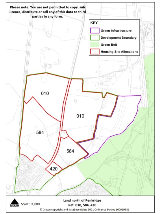
Site reference |
420, 584 & 010 |
Village |
Penkridge |
|
Minimum capacity |
1129 dwellings |
Address |
Land north of Penkridge off A449 and Lower Drayton Farm |
|
Site area |
65.7 ha |
Proposed use |
Housing-led mixed use |
|
|
|||
|
Site infrastructure and access requirements |
To deliver site in accordance with site specific requirements, Supplementary Planning Document and masterplanning process set out in Policy SA4. |
||
|
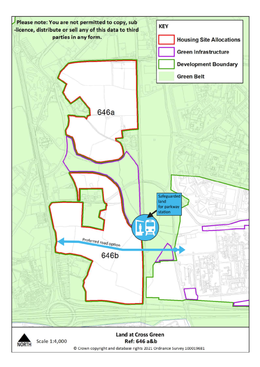
Site reference |
646a&b |
Location |
North of the Black Country |
|
Minimum capacity |
1200 dwellings |
Address |
Land at Cross Green (Brewood and Coven Ward) |
|
Site area |
54.3 ha |
Proposed use |
Housing-led mixed use |
|
|
|||
|
Site infrastructure and access requirements |
To deliver site in accordance with site specific requirements, Supplementary Planning Document and masterplanning process set out in Policy SA2. |
||