Publication Plan November 2022
5. Development Strategy
Green Belt
(1) 5.1 The distinctive character of South Staffordshire is directly influenced by the fact that approximately 80% of the district is Green Belt. This contributes to the district's rural character and helps distinguish the district from neighbouring urban areas such as the Black Country. Protecting the Green Belt from unplanned development as far as possible is therefore a key objective (Strategic Objective 1) of the Local Plan. However, national policy requires us to balance the need to protect the Green Belt with the need to deliver a sustainable growth strategy that meets the district's development needs, including for new housing and employment.
(1) 5.2 Therefore, Green Belt is only released through the Local Plan where necessary and fully justified. In line with national policy, Green Belt boundaries can only be amended through the review of a Local Plan, and therefore a policy setting out where the council's development strategy requires such Green Belt amendments is necessary, as well as ensuring a strong policy framework for resisting planning applications that would result in inappropriate development in the Green Belt.
(2) 5.3 Wherever possible, the council has looked to allocate suitable brownfield sites first and foremost, to reduce pressure on the district's Green Belt, however these are very limited due to the largely rural nature of the district. Most large-scale site options on brownfield land are either in isolated rural locations or form part of the district's employment land supply and need to be retained to ensure the district can meet its employment land needs. Previous Local Plans also identified large brownfield sites in the Green Belt (known as major developed sites in the Green Belt) but all of these have now been developed. There is an area of brownfield land adjacent to the south-western edge of Wombourne, which is mainly occupied by the car storage company Copart. This site has been assessed as an option for housing, however it is not proposed for allocation due to uncertainty over the relocation of the existing business. Elsewhere, brownfield opportunities in sustainable locations tend to be small scale (e.g. garage sites, small infill plots, changes of use under permitted development) and if unconstrained have historically come forward through the Development Management process and outside of the Local Plan, as the principle of such schemes is generally considered acceptable. The council has included a windfall allowance for these smaller site opportunities within the housing trajectory to ensure this is accounted for in future supply.
5.4 In order to deliver the vision for the district over the plan period it is essential that there is a strong policy position for protecting the Green Belt as far as possible and this is set out in Policy DS1 below.
(42) Policy DS1 – Green Belt
Within the West Midlands Green Belt, as defined on the policies map, opportunities to enhance the beneficial use of the Green Belt will be supported. This may include opportunities to provide access, for outdoor sport and recreation, to retain and enhance landscapes, visual amenity and biodiversity, or to improve damaged and derelict land.
Development within the Green Belt must retain its character and openness. Inappropriate development is, by definition, harmful to the Green Belt and will not be supported except in very special circumstances. Very special circumstances will not exist unless the potential harm to the Green Belt by reason of inappropriateness, and other harm, is clearly outweighed by other considerations.
The construction of new buildings within the Green Belt should be regarded as inappropriate, unless it is for one of the exceptions listed within the NPPF. A separate Green Belt Supplementary Planning Document (SPD) will be prepared for further guidance.
Limited affordable housing for local community needs in the Green Belt will be supported on small rural exceptions sites where the development complies with Policy HC6.
The Green Belt boundary will be altered through this Plan to accommodate development allocations set out in Policies SA1, SA2, SA3, SA5 and SA7. The boundaries of the reviewed Green Belt sites are identified in Appendices B-E of this document and on the policies map.
Development proposals should be consistent with other Local Plan policies.
Green Belt compensatory improvements
5.5 The NPPF requires local plans releasing Green Belt to set out ways in which the impact of altering Green Belt boundaries can be offset through compensatory improvements to the environmental quality and accessibility of remaining Green Belt land. It is therefore important that this Local Plan provides a mechanism to secure such improvements for any sites released from the Green Belt.
5.6 The district has a large rural area enclosing its numerous villages, the majority of which is covered by Green Belt. There are therefore a significant number of options available to sites in improving the environmental quality and accessibility of remaining Green Belt, many of which are set out in the district's Open Space Strategy and Nature Recovery Network mapping. Policy DS2 intends to offer a mechanism for delivering these improvements, offering a stepped approach to ensure that any compensatory improvements offer the greatest benefit to communities in closest proximity to land released from the Green Belt where possible.
(21) Policy DS2: Green Belt Compensatory Improvements
Planning permission will not be granted for development of sites removed from the Green Belt through the Local Plan unless and until appropriate additional compensatory improvements to environmental quality and accessibility of remaining Green Belt are incorporated into a Section 106 agreement. As a starting point any compensatory improvements should be in addition to other local plan policy standards.
Where compensatory improvements have been identified in the Local Plan on remaining Green Belt land adjacent to an allocated site, such improvements must be secured through planning applications for these developments. Where areas of land for compensatory improvements have not been identified adjacent to a site through the Local Plan, applicants must demonstrate proportionate compensatory improvements to remaining Green Belt land in accordance with the following hierarchy:
- Compensatory improvements to remaining Green Belt land adjacent to, or in close proximity to the development site;
- Compensatory improvements to remaining Green Belt land within the wider locality accommodating the development;
- Compensatory improvements to remaining Green Belt land in an area identified through the council's latest Nature Recovery Network mapping or Open Space Strategy.
In the event that it is robustly demonstrated that none of the above options can be satisfied (e.g. as land is demonstrably not available) then the council will accept a commuted sum that it will use to undertake compensatory improvements.
Development proposals should be consistent with other Local Plan policies.
Open Countryside
5.7 Equally important to maintaining the special character of South Staffordshire is having a policy framework for protecting the Open Countryside located to the northwest of the district beyond the Green Belt. Whilst not having the same level of national protection as Green Belt designation, the land designated in the Local Plan as Open Countryside is still much valued countryside particularly for its landscape and ecological qualities. It is therefore important as part of the district's wider development strategy, that a clear policy approach on what type of development is explicitly permitted in the Open Countryside is set out in this Local Plan. Equally, it will need to set out what policy factors proposals will need to be consistent with for development in the Open Countryside to be acceptable in principle.
(8) Policy DS3 – Open Countryside
The district's Open Countryside is defined as the area in the district which is both beyond the West Midlands Green Belt and outside of individual settlements' development boundaries, as indicated on the Policies Map.
The Open Countryside contains many sensitive areas, including its landscapes and areas of ecological, historic, archaeological, agricultural and recreational value. The council will protect the intrinsic character and beauty of the Open Countryside whilst supporting development proposals which:
- Assist in delivering diverse and sustainable farming enterprises;
- Deliver/assist in delivering other countryside-based enterprises and activities, including those which promote the recreation and enjoyment of the countryside, such as forestry, horticulture, fishing and equestrian activities;
- Provide for the sensitive use of renewable energy resources (in conjunction with Policy NB5); or
- Enable the re-use of an existing building, providing that the proposed use of any building (taking into account the size of any extensions, rebuilding or required alterations), would not harm the intrinsic character and beauty of the Open Countryside.
The policy provisions set out above indicate the types of development which will, in principle, be supported within the Open Countryside. In addition to the requirements set out in this policy, any proposed scheme must also be consistent with any relevant policies set out elsewhere within the Local Plan in order to be supported.
All types of development in the Open Countryside which are not explicitly supported by Policy DS3 will be considered on a case-by-case basis. Such proposals will only be permitted where they are not located on best and most versatile agricultural land and are fully consistent with any other relevant policies set out elsewhere in the Local Plan. These include, but are not limited to, policies which relate to the district's:
- overall development strategy
- design standards
- landscape character and assets
- historic assets
- ecological assets and biodiversity
- recreational assets
- housing mix requirements (where applicable)
- sustainable travel requirements
The Open Countryside boundary will be altered through this Plan to accommodate the relevant development allocations set out in Policies SA4 and SA5. The boundaries of the reviewed Open Countryside sites are identified in Appendices B and C of this document.
Development proposals should be consistent with other Local Plan policies.
Housing
The district's housing needs
5.8 A key part of the new Local Plan is to establish the role that South Staffordshire council can play in meeting both its own housing needs and those of the wider Greater Birmingham and Black Country Housing Market Area (GBBCHMA), which contains local authorities with significant unmet housing needs (Birmingham and the Black Country).
(1) 5.9 The plan period runs from 2018 onwards, so it is also necessary for the plan to take account of the 992 dwellings already delivered in the district between 2018-2022 in any future housing needs. The district's future housing need is then calculated using the government's standard method for calculating housing needs and added to this figure. This currently requires the district to deliver a minimum annual average of 241 dwellings per annum, starting from the current year (2022) and running to the end of the plan period (2039).
Unmet housing needs from the wider housing market area
5.10 In addition to the district's own housing needs, there is emerging evidence of unmet needs from the wider GBBCHMA, within which South Staffordshire sits. The two most significant sources of potential unmet needs are currently Birmingham City and the Black Country. The adopted Birmingham Development Plan[1] and emerging urban capacity evidence from the Black Country[2] suggests that a significant unmet need is arising across the GBBCHMA, driven by limited housing land in these urban areas.
5.11 Recognising the existing and emerging shortfalls, the fourteen GBBCHMA local authorities[3] jointly prepared the GBBCHMA Strategic Growth Study in 2018. This drew together existing evidence on housing supply and need across the entire housing market area, estimating that at that time the unmet needs of the GBBCHMA sat at around 28,000 dwellings up to 2031, rising to nearly 61,000 dwellings by 2036.
(1) 5.12 In light of these unmet needs, the study recommended a series of strategic growth locations across the housing market area, including a number of locations in South Staffordshire. Using this evidence, it was proposed to test an additional contribution of 4,000 dwellings to the unmet housing needs of the GBBCHMA in the council's Local Plan review, based on the scale of growth implied in the district by the strategic locations identified in the GBBCHMA Strategic Growth Study. Alternative levels of growth have also been tested through the Sustainability Appraisal process. The district's proposed contribution to wider unmet housing needs was initially proposed in the previous 2018 Issues and Options consultation. This was done to ensure that the level of growth capable of being accommodated in South Staffordshire was based on a consistent HMA evidence base that consistently considered the sustainability, deliverability and infrastructure of strategic locations across the GBBCHMA. It also ensured that the issue of unmet housing needs was considered from the earliest stage possible in the plan's preparation and to provide Duty to Cooperate partners with the chance to comment on the approach from the earliest stage of the plan-making process.
(1) 5.13 Since it was proposed to accommodate this level of growth in 2018, updated land supply statements produced by the GBBCHMA local authorities have indicated the extent of the housing shortfall up to 2031 appears to have fallen significantly, whilst also indicating that the Black Country's urban capacity evidence shows a significant level of housing need arising into the later 2030s[4]. This is also reflected in the 2021 Draft Black Country Plan consultation, which seeks to deliver housing in urban areas and through Green Belt release to meet the area's housing needs, delivering 47,837 homes within the Black Country up to 2039 whilst indicating a potential shortfall of 28,239 homes they seek to export through the Duty to Cooperate. In October 2022 Birmingham City Council started the process of agreeing an Issues and Options consultation for their new Local Plan which includes an early indication of a 78,415 home and 73.6ha employment land shortfall. These figures are based on current land availability before considering potential Green Belt release in Birmingham, but even if additional land supply can be identified, it is still likely that a significant shortfall from Birmingham will remain.
5.14 The council will continue to encourage Birmingham and the Black Country authorities to ensure that housing supply within their administrative areas is truly maximised prior to being exported to other areas[5]. This includes requiring the Black Country to ensure the recommendations from the West Midlands Combined Authority's recent review[6] of the Black Country's urban capacity are fully reflected in the Black Country's land supply, whilst also ensuring that the Black Country maximises the recommendations set out in the GBBCHMA Strategic Growth Study 2018 within its area, prior to requiring other authorities to release Green Belt to meet unmet needs.
5.15 Given the evidence to date, it is still clear that a significant housing shortfall is likely to remain across the GBBCHMA, although its exact extent is not currently known. The council and other GBBCHMA partners recognise the need to update the GBBCHMA Strategic Growth Study 2018 to ensure a comprehensive picture of unmet needs and locations for growth is provided. This work, once completed, will help to inform the need for and scope of future reviews of the Local Plan and the council will continue to play a proactive part in cross-boundary agreements to address the housing shortfalls.
(1) 5.16 Correspondence to date from key Duty to Cooperate partners, particularly Birmingham City Council and the Black Country local authorities, has not raised concerns with the council's proposed contribution; and currently the GBBCHMA-wide evidence base has not been updated to recommend alternative or additional strategic locations for housing growth. In light of the above factors, it is considered that there is still a need to deliver the strategic growth recommended in the GBBCHMA Strategic Growth Study, in order to ensure that that emerging and existing shortfalls from the conurbation are addressed in a genuinely sustainable manner, reflecting the comparative sustainability of specific development opportunities across the GBBCHMA. South Staffordshire therefore proposes retaining the 4,000 dwelling contribution towards the unmet needs of the housing market area and will adjust the housing target accordingly to deliver this. It is also acknowledged that in light of emerging housing shortfalls across the GBBCHMA an update to the Strategic Growth Study 2018 may be required to provide an up-to-date picture on options to address unmet housing needs. The council has worked collaboratively with neighbouring authorities in drafting a HMA-wide Statement of Common Ground to set out a roadmap for this further work.
The proposed housing target
(11) 5.17 Reflecting these issues, South Staffordshire is proposing to plan for a housing target of 9,089 dwellings between 2018 and 2039. This will allow the district to meet its own housing needs over the plan period, whilst also making a proportionate and justified contribution to the unmet needs of the GBBCHMA. The specific elements of the housing target can be summarised as set out below:
|
South Staffordshire's own housing need using the government's standard method (2022-2039) |
4,097 |
|
Completions in the district since the start of the plan period (2018-2022) |
992 |
|
Additional housing to contribute towards the unmet needs of the GBBCHMA |
4,000 |
|
Total number of dwellings to be planned for |
9,089 |
Table 7: Housing Target
Spatial strategy for housing
5.18 To consider how this level of housing growth could be accommodated, the district previously consulted on a Spatial Housing Strategy and Infrastructure Delivery (SHSID) consultation in October 2019. This looked at how the proposed housing target could be distributed between different settlements and other broad locations within the district, informed by strategic evidence on the sustainability and sensitivity of these different locations. A preferred infrastructure-led spatial housing strategy was identified in this consultation (Option G).
(2) 5.19 Following the 2019 Spatial Housing Strategy and Infrastructure Delivery consultation, the council proposed a number of changes to its preferred spatial strategy to inform the 2021 Preferred Options consultation. It reflected responses to the 2019 consultation and the results of the site assessment process to arrive at the exact level of growth given to each area of the district. In summary, key changes made were:
- Increasing growth proposed North of Penkridge to better reflect the findings of the GBBCHMA Strategic Growth Study and non-Green Belt land available north of the village;
- Allowing for further limited growth at Cheslyn Hay/Great Wyrley beyond the existing allocated/safeguarded land, recognising the area's Tier 1 settlement status, but balancing this against the lack of a strategic recommendation for these villages in the GBBCHMA Strategic Growth Study and the site specific constraints affecting land in the area;
- Limiting new allocations at Perton to the existing safeguarded land, reflecting the lack of a finalised junction improvement scheme at the A41 and the remoteness of Green Belt site options from education facilities;
- Reducing the amount of growth allocated to the western edge of the Black Country, reflecting the relatively limited unmet need arising from Dudley Metropolitan Borough, which also holds significant Green Belt site options in this area within its own administrative boundary as set out in the GBBCHMA Strategic Growth Study;
- Removing the proposal to identify small site allocations in Tier 4 villages, as current monitoring information suggests these allocations are not required to meet the national requirement for 10% of housing growth to be delivered on sites of less than 1 hectare;
- Identifying villages, namely Brewood and Great Wyrley, where specialist elderly housing allocations may address existing imbalances between local needs and supply[7]
(2) 5.20 Taken together, these factors led to a revised spatial strategy for housing delivery in the district, which then informed the 2021 Preferred Options consultation. Following consultation on the 2021 Preferred Options a number of further changes were made to reflect updated evidence base documents and site-specific comments made by stakeholders and local residents. These included:
- Extending the plan period by one year to allow for a realistic timeframe for plan delivery;
- Identifying limited additional brownfield sites and updates to windfall allowances to reflect updated urban capacity work and new call for sites suggestions;
- Altering some greenfield site sizes to provide better access and layout opportunities;
- Allocating an additional site at Boscomoor Lane Penkridge, reflecting its lower Green Belt harm and sustainable location;
- Removing some sites at Huntington, Wheaton Aston, Kinver and Pattingham owing to a variety of sustainability, heritage, landscape and environmental concerns;
- Removing allocations of 1ha or less from sites solely in the Green Belt in smaller villages, as the council can deliver its small sites duty in more sustainable locations without this supply;
- Reducing growth at land south of Stafford to reflect landscape and heritage concerns;
(7) 5.21 As well as reflecting key policy and environmental constraints affecting the district, the council's final preferred strategy aims to locate new housing in locations with better access to existing infrastructure and services or where new development could facilitate new infrastructure delivery. It also seeks to deliver a balance of housing sites across the district, balancing the need for housing growth early in the plan period and for 10% of housing growth to be delivered on sites of less than 1 hectare, with the need for larger sites to deliver growth later in the plan period.
|
Spatial Housing Strategy 2018 - 2039 |
Indicative minimum dwelling numbers 2018-2039[8] |
|||
|
Location |
Total proportion of housing delivery |
Existing planning permissions and allocations |
Safeguarded land |
New allocations |
|
The district's rural area |
||||
|
Tier 1 villages |
40.5% |
1228 |
890 |
2042 |
|
Penkridge |
17.8 % |
529 |
88 |
1209 |
|
Codsall/Bilbrook |
16.8 % |
462 |
584 |
679 |
|
Cheslyn Hay/Great Wyrley |
5.9 % |
236 |
218 |
154 |
|
Tier 2 villages |
16.5% |
723 |
614 |
310 |
|
Wombourne |
8.0 % |
300 |
280 |
245 |
|
Brewood |
1.8 % |
77 |
63 |
43 |
|
Kinver |
2.6 % |
136 |
82 |
44 |
|
Perton |
3.7 % |
226 |
150 |
0 |
|
Huntington |
0.5 % |
9 |
39 |
0 |
|
Tier 3 villages |
5.9% |
472 |
100 |
37 |
|
Essington |
2.3 % |
235 |
0 |
0 |
|
Coven |
1.1 % |
66 |
48 |
0 |
|
Featherstone |
1.2 % |
86 |
35 |
0 |
|
Shareshill |
0.0 % |
3 |
0 |
0 |
|
Wheaton Aston |
0.8 % |
67 |
0 |
15 |
|
Pattingham |
0.2 % |
7 |
17 |
0 |
|
Swindon |
0.3 % |
9 |
0 |
22 |
|
Tier 4 villages |
0.4% |
43* |
0 |
0 |
|
Growth in other rural locations and Tier 5 settlements |
2.8% |
258* |
0 |
0 |
|
Areas adjacent to neighbouring towns and cities |
||||
|
Employment-led growth at Land at Cross Green (Brewood and Coven Ward) |
11.7% |
0 |
0 |
1,200 |
|
Northern edge of the Black Country at Land north of Linthouse Lane (Essington Ward) |
11.7% |
0 |
0 |
1,200 |
|
Western edge of the Black Country at Land at Langley Road (Wombourne North and Lower Penn Ward) |
3.8% |
0 |
0 |
390 |
|
South of Stafford at Land at Weeping Cross (Penkridge North East and Acton Trussell Ward) |
0.8% |
0 |
0 |
81 |
|
Other sources of supply |
||||
|
Windfall development on small sites |
5.8% |
600 |
0 |
0 |
Table 8: How housing growth will be distributed across the district
(2) 5.22 In total, this distribution of growth exceeds the minimum amount of land release required to meet the district's 9,089 dwellings housing target. This will help the plan to meet the national policy requirement to respond to changing circumstances in the plan period and demonstrate plan flexibility.
5.23 Housing numbers for each village/broad location are influenced by the need to distribute the overall housing requirement sustainably to reflect the settlement hierarchy, (as informed by the Rural Services and Facilities Audit 2021); the evidence base (e.g. GBBCHMA Strategic Growth Study 2018); the level of constraints present around each village/broad location; and national policy factors (e.g. the requirement for 10% of site to be less than 1ha).The full set of factors were considered in the 2019 SHSID consultation document.
5.24 The sections that follow set out the strategy for delivering our housing growth in different areas of the district. The diagrams and descriptions that follow summarise only the locations that will be the focus for new housing allocations. They do not include existing planning permissions within the district, which make up the remainder of the housing growth for the plan period up to 2039, as set out in Table 8.
Housing growth in Locality 1
5.25 The diagram below summarises where new housing growth will be delivered in Locality 1 (the north of the district).
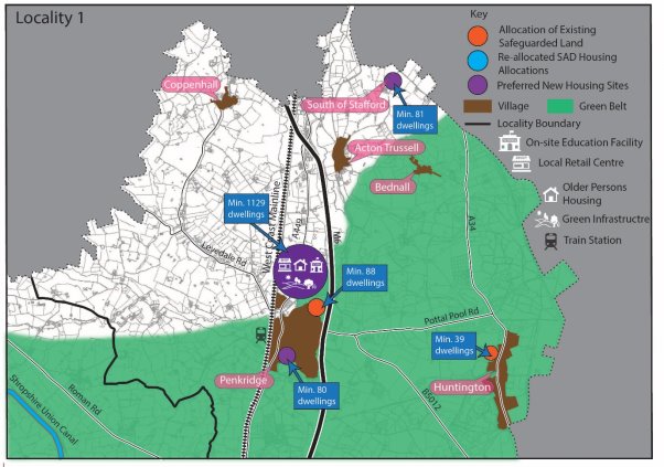
Penkridge
(1) 5.26 Housing growth in this part of the district will be driven by a large-scale extension in the Open Countryside to the north of Penkridge. This larger scale development will deliver significant housing growth alongside a mix of other uses, including a new first school, local retail and a country park. This recognises the recommendations for a large-scale extension north of Penkridge in the GBBCHMA Strategic Growth Study, the non-Green Belt land available in this area of the village and the greater level of services and facilities in Penkridge compared to other villages in the district, including access to a railway station. The council has also proposed an additional amount of limited Green Belt release to the south of the village, recognising the sustainability of this location compared to other areas of the district.
5.27 The delivery of the existing non-Green Belt safeguarded land in the village will also be brought forward, to ensure that sustainable non-Green Belt sites in the district are delivered.
Southern Edge of Stafford (A34 corridor)
5.28 This location will not be a focus for larger-scale housing growth. This recognises the sensitive landscape and potential highways concerns that larger scale growth in this location could cause, as well as the lack of unmet housing needs in Stafford and the location's remoteness from areas of unmet needs in the wider GBBCHMA. Instead, a smaller scale extension to the adjacent town of Stafford will be delivered in this area, which will ensure the sustainable delivery of non-Green Belt housing land in the district.
Huntington
5.29 Housing growth in the village will be limited to the safeguarded land previously identified adjacent to the village. Further Green Belt release has not been proposed in this area, recognising the impacts of growth adjacent to the village on the nearby AONB.
Housing growth in Locality 2
5.30 The diagram below summarises where new housing growth will be delivered in Locality 2 (the north-west of the district).
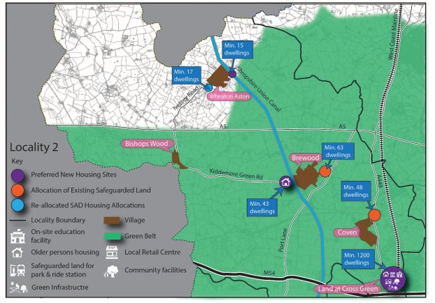
Land at Cross Green
(1) 5.31 Housing growth in this part of the district will be driven by a large-scale housing site at Land at Cross Green. Growth in this area will deliver significant housing alongside a mix of other uses, including a new primary school, local retail and strategic green infrastructure. It also provides the opportunity to safeguard land to deliver the rail-based parkway opportunity identified in the district's 2012 Core Strategy adjacent to the West Coast Mainline. Delivering housing growth in this location recognises the recommendations for a strategic housing site in this area in the GBBCHMA Strategic Growth Study and the area's proximity to significant employment opportunities at ROF Featherstone strategic employment site, as well as being close to i54 South Staffordshire. It also recognises the infrastructure that could be facilitated by large scale growth and the area's proximity to the City of Wolverhampton, with its associated services and employment opportunities.
Brewood
5.32 Housing growth in the village will be delivered through limited land release alongside the delivery of the safeguarded land previously identified adjacent to the village. This approach balances the historic character of the village, the extent of Green Belt land in this area and the relative level of services and facilities in Brewood compared to other settlements in the district. It also recognises the potential for additional allocations to be made to address the acute local need for specialist elderly housing in this location.
Coven
5.33 Housing growth in the village will be limited to existing planning permissions, sites within the existing development boundary of the village and the delivery of the safeguarded land adjacent to the village. This approach recognises the existing housing growth already delivered around the village during the plan period, the village's relatively limited services and facilities and its proximity to more sustainable larger scale growth options proposed adjacent to the northern edge of the Black Country.
Wheaton Aston
5.34 Housing growth in the village will be delivered through limited land release to deliver a small site of less than one hectare within the village's development boundary. This approach recognises the existing housing growth already delivered around the village during the plan period, the village's relatively limited services and facilities, concerns raised by a statutory body and the non-Green Belt land opportunities available in and around the village.
Housing growth in Locality 3
5.35 The diagram below summarises where new housing growth will be delivered in Locality 3 (the north-east of the district).
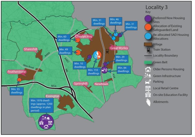
Cheslyn Hay/Great Wyrley
5.36 New housing growth in this area will be increased through the delivery of new allocations, which will be directed to less constrained site options around the two villages. These will be delivered alongside the existing allocated and safeguarded housing sites dispersed around the two villages.
5.37 The delivery of new housing allocations in Cheslyn Hay/Great Wyrley recognises the greater level of services and facilities to support local growth in these villages and the potential for additional allocations to be made to address the acute local need for specialist elderly housing in this location. Unlike other Tier 1 settlements (Penkridge & Codsall/Bilbrook), growth in Cheslyn Hay/ Great Wyrley is tempered by the lack of a large-scale growth identified for the villages in the GBBCHMA Strategic Growth Study, the alternative options to locate growth to meet GBBCHMA unmet needs directly adjacent to the northern edge of the Black Country and the site-specific constraints affecting numerous site options in this area.
Northern edge of the Black Country
5.38 Housing growth in this part of the district will be driven by a large-scale housing site (land north of Linthouse Lane) adjacent to the northern edge of the Black Country urban area. Growth in this area will deliver significant housing alongside a mix of other uses, including a new primary school, local retail and strategic green infrastructure. Delivering housing growth in this location recognises the infrastructure that could be facilitated on a larger strategic housing site and the area's proximity to the higher order services and facilities in the cities and towns of the Black Country.
Featherstone & Shareshill
5.39 Housing growth around these villages will be limited to existing planning permissions, sites within the existing development boundaries of the villages and the delivery of the safeguarded land adjacent to Featherstone. This approach recognises both villages' relatively limited services and facilities, their proximity to more sustainable larger scale growth options proposed adjacent to the northern edge of the Black Country, and the existing growth already delivered at Featherstone during the plan period.
Essington
5.40 Housing growth in the village will be limited to sites within Essington's existing development boundary and existing planning permissions around the village. This approach recognises the significant existing housing growth already delivered around the village during the plan period, the village's relatively limited services and facilities and its proximity to more sustainable larger scale growth options proposed adjacent to the northern edge of the Black Country.
Housing growth in Locality 4
5.41 The diagram below summarises where new housing growth will be delivered in Locality 4 (the central area of the district).
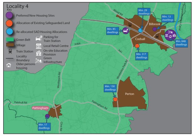
Codsall/Bilbrook
(4) 5.42 Housing growth in this part of the district will be largely focused on Codsall/Bilbrook. Increased allocations around the village will deliver housing growth alongside a mix of other uses, including a new first school, local retail and strategic green infrastructure. This recognises the recommendations for proportionate dispersal around Codsall/Bilbrook in the GBBCHMA Strategic Growth Study and the greater level of services and facilities in this area compared to other villages in the district, including access to two railway stations. The level of growth to be delivered is also aligned to the level of growth advised by the Education Authority to deliver an appropriately sized First School in this location whilst avoiding creating capacity issues at the Middle and High School level. It also offers opportunities to deliver additional station car parking at Codsall.
Perton
(1) 5.43 The council has reduced the level of growth proposed in this location since the previous Local Plan review consultation, removing the recommendation for a new land allocation in this area. This change recognises the significant constraints identified in the site assessment process affecting new site options around the village, including highways concerns, proximity to education and Green Belt/landscape sensitivities. Due to these issues and the need to only release Green Belt in exceptional circumstances, housing growth in Perton will be limited to existing planning permissions, sites within the existing development boundaries of the villages and the delivery of the safeguarded land adjacent to Perton.
Pattingham
5.44 Housing growth in the village will be delivered through the delivery of the safeguarded land identified adjacent to the village, with no additional Green Belt release proposed. This approach recognises the limited level of services and facilities in Pattingham compared to other settlements in the district and the extent of Green Belt land around the village.
Housing growth in Locality 5
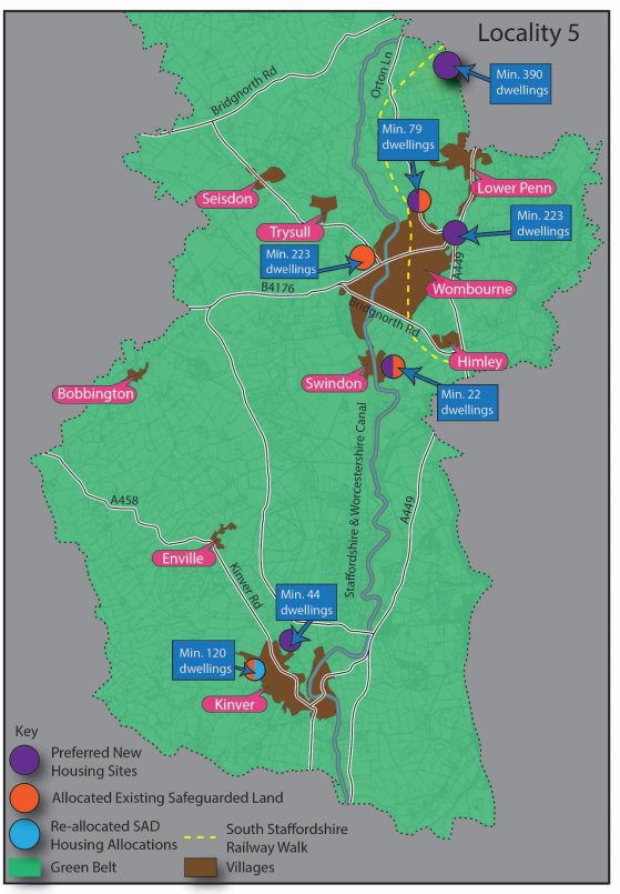
(3) 5.45 The diagram below summarises where new housing growth will be delivered in Locality 5 (the south of the district).
Wombourne
(7) 5.46 Housing growth in this area will be increased through the delivery of new housing allocations around Wombourne, which will be brought forward alongside the existing allocated and safeguarded housing sites dispersed around the village. Recognising that previously developed land adjacent to the village is either unsuitable or unavailable, significant Green Belt release has been focused on the north-east of the village. This recognises this location's good proximity to a variety of services and facilities, including regular public transport, as well as its relatively low Green Belt harm compared to other areas in the district.
Western edge of the Black Country
5.47 Housing growth will be delivered adjacent to the western edge of the Black Country, allowing for the limited expansion of the Black Country urban area. This will be delivered through a smaller urban extension to the Black Country, directed towards a relatively less constrained site within the Green Belt compared to other site options along the western edge of the Black Country.
5.48 This area provides an opportunity to accommodate housing growth directly adjacent to the towns and cities within the Black Country, in a location identified as a strategic priority for dispersed housing growth in the GBBCHMA Strategic Growth Study. These factors have been balanced against the poorer access to employment via sustainable transport measures in this broad location and the lack of larger scale site options to deliver sustainable mixed-use growth in this area. The extent of land adjacent to Dudley Metropolitan Borough Council has also informed the level of growth allocated in this area, as Dudley MBC has a relatively limited unmet housing need and significant Green Belt opportunities within its own administrative boundaries to address this need.
Kinver
5.49 Housing growth in the village will be delivered through limited land release alongside the delivery of the safeguarded land identified adjacent to the village. This approach balances the historic character of the village, the extent of Green Belt land in this area and the relative level of services and facilities in Kinver compared to other settlements in the district.
Swindon
(1) 5.50 Housing growth in the village will be delivered through an additional small site allocation alongside the delivery of the safeguarded land identified adjacent to the village, to ensure that the existing allocation can be delivered in the most appropriate way, whilst accommodating affordable housing provision towards the district's needs. This approach recognises the extent of Green Belt land in this area and the limited level of services and facilities in Swindon compared to other settlements in the district.
Gypsies and Travellers
(1) 5.51 It is also a requirement of the Local Plan to assess and plan to meet the housing needs of different groups of the community, including Gypsies, Travellers and Travelling Showpeople. The Government's Planning Policy for Traveller Sites (PPTS) 2015 details how travellers' housing needs should be assessed for those covered by the definition in Annex 1 of that document. The focus of Gypsy, Traveller and Travelling Showpeople policies in this plan is therefore to make provision for those traveller families that meet the definition set out in the PPTS, with the needs of those not meeting this definition met through general needs housing policies.
5.52 In line with national policy, the needs for families have been assessed through the Gypsy and Traveller Accommodation Assessment (GTAA) 2021 and Pitch Deliverability Study (2021). This evidence demonstrates that need is being generated by existing families. Some of this is current need as a result of being on an unauthorised pitch and overcrowding. However, the vast majority of need is generated through household formation derived from the demographics of residents and teenagers on sites needing a pitch of their own within the next five years.
5.53 Due to this, the council's strategy for new Gypsy, Traveller and Travelling Showperson provision will be to continue to deliver privately owned sites/pitches to meet the needs of existing families. The evidence supports an approach therefore of looking to allocate existing temporary or unauthorised sites to permanent (subject to other planning considerations) and looking to intensify and extend existing sites to meet identified family need, rather than allocating wholly new sites that may have been suggested by non-travellers, and where deliverability is more uncertain. This approach will see the continued concentration of traveller pitches where sites have historically been consented on appeal in the north of the district predominantly along the A449 and A5 transport corridors. It is currently not possible to test an alternative distribution of traveller pitches that would disperse pitches more widely across the district due to a lack of deliverable alternative pitch options elsewhere in the district.
Employment
The district's employment needs
(2) 5.54 It is the role of the Local Plan to consider the district's employment needs and plan for employment growth over the plan period, taking account of the evidence of need and the existing pipeline of employment land. An updated Economic Development Needs Assessment (EDNA) to inform the emerging Local Plan was published in 2022 and was an update to a previous EDNA published in 2018. An update was considered necessary in order to have regard to changes in employment projections, including as a result of Brexit and Covid, and to ensure that the employment evidence to support the Local Plan was robust and up to date.
5.55 The EDNA 2022, in accordance with the PPG, analysed the socio-economic landscape of the district (including around employment, business development, demographics and labour markets) and concluded that the local economy in South Staffordshire was healthy and was still benefiting from investment particularly as a result of strategic site delivery in the district. The EDNA also analysed which authorities South Staffordshire had the strongest economic links with and from this identified a Functional Economic Market Area (FEMA) comprising of South Staffordshire, Cannock, Dudley, Stafford, Walsall and Wolverhampton.
5.56 The study's main focus was to draw together the market intelligence, economic forecasts and other relevant data to conclude on the employment land needs of the district up until 2040. The study included detailed analysis of employment projections on a sector-by-sector basis utilising data from the three main forecasting houses. The study adjusted the Experian forecast to arrive at a 'LEP based Growth Scenario' and following a series of further adjustments (e.g. building in plan flexibility such as projected employment losses), arrived at an objectively assessed employment land need figure of 63.6ha up to 2040.
5.57 The study also undertook analysis on the impact of West Midlands Interchange (WMI) on the district, including on the demand for employment, as well as considering the proportion of WMI that could contribute towards the supply of employment land for South Staffordshire given the strategic nature of the site. This concluded that 18.8ha of WMI would contribute towards the district's supply of employment land to meet the projected demand.
5.58 The EDNA undertook further analysis by examining the supply/demand balance for the district, in order to inform the amount of employment land that would need to be allocated through the Local Plan. It considered the supply of employment land at the base date of April 2020 (99ha) and explored how this would likely be split between strategic and non-strategic employment land supply. Following consideration of the supply/demand balance specifically for strategic sites, it was concluded what proportion of the surplus strategic employment land could be attributed to sub regional supply and what proportion could be considered towards South Staffordshire's supply, informed by the labour demand forecasts. It concluded that in terms of strategic employment land, 36ha (excluding WMI) could reasonably be attributed to cross boundary unmet needs, whilst the supply-demand balancing exercise that could be attributed to South Staffordshire, taking on board both strategic and non-strategic employment land, concluded that there was a small surplus expected to be around 1.5ha. Overall, the district can meet its own employment land needs, together with making a proportionate contribution to unmet needs in the Black Country.
Unmet employment needs from the wider functional economic area
5.59 National planning practice guidance requires authorities consider the 'most appropriate geography' to prepare policies for employment and require authorities to define their 'best fit' Functional Economic Market Area. Given this, it is over the South Staffordshire FEMA geography that it is considered the most appropriate basis for considering our role in meeting cross boundary employment needs.
5.60 Of the other authorities within the South Staffordshire FEMA, Cannock Chase District Council are also in the process of preparing their new Local Plan. In February 2021 they consulted on their Preferred Options consultation which indicated that 50ha of employment land will be provided over the plan period to meet Cannock's employment needs. There is currently no indication that Cannock are unable to meet this need within their administrative boundary. Stafford Brough consulted on their Issues and Options document in 2020 where they set out a range of demand scenarios between 17,548m2 and 176,548m2 of employment floorspace over the period 2020-2040 as informed by their HEDNA. It is expected that Stafford Borough's next Local Plan consultation will be more explicit on the amount of additional employment floorspace that will be delivered through the plan, however there is no indication to date that Stafford will not be able to meet its own development needs.
(1) 5.61 The Black Country authorities are also preparing their Local Plan with the Black Country Draft Plan (August 2021) confirming that they have a need of 565ha of employment up until the end of their plan period (2039). The Black Country Draft Plan confirms they are only able to deliver 355ha of this, leaving a shortfall of 210ha. Their Draft Plan indicates that this unmet need should be exported, as far as possible, to authorities that have a strong existing or potential functional economic relationship with the Black Country; to be agreed through a Statement of Common Ground.
5.62 Site assessment of employment site options (existing sites with available land parcels and new site options) have been undertaken, which has re-confirmed that those sites assessed as part of the supply/demand exercise in the EDNA 2022 that did not have planning permission at the base date of April 2020 are suitable for allocation. As such, the findings of the supply/demand exercise and the conclusion in the EDNA that 36.6ha of strategic employment land is available for unmet cross boundary needs has been confirmed. In addition, WMI represents a significant supply of employment land within the district that will come forward within the plan period. As confirmed through the EDNA 2022, South Staffordshire requires 18.8ha of WMI within our supply to meet our forecast labour demand, leaving a considerable proportion of the site available to meet cross boundary needs. The Black Country commissioned a report considering the proportion of WMI that could be considered towards their needs based upon projected population change. This identified a minimum 67ha Black Country 'claim' of WMI which when taken alongside the 36.6ha surplus of strategic employment land means that 103.6ha of employment land in South Staffordshire is available for strategic cross boundary unmet needs from the Black Country, subject to agreement through a Statement of Common Ground.
Strategic Employment Sites
(1) 5.63 The issue of strategic employment delivery across the wider West Midlands region has started to be explored most recently through the West Midlands Strategic Employment Sites Study (WMSESS) 2021. The WMSESS 2021 was commissioned by Staffordshire County Council, Black Country LEP, Greater Birmingham and Solihull LEP and Coventry and Warwickshire LEP with local planning authorities in the region not directly involved in the study. In this context, the study's primary focus was around engagement with the private sector to gauge market demand for new strategic employment sites, to examine recent take up, and to identify broad areas of market demand. It did not provide a full assessment of need (in terms of floorspace) that could be attributable at LPA level, nor did it examine some key national policy constraints (e.g. Green Belt). To this end the study recommended a more detailed follow up study should be progressed across the WMSESS study area to properly establish the extent of any shortfall, conduct site assessments and address policy constraints (e.g. Green Belt) in more detail. This strategic issue is now being progressed via a proposed follow-on study with LPAs over the study area leading the work. This will allow the need issue to be explored in more detail and examine how evidenced need for strategic employment sites interacts with need identified through individual LPAs' EDNAs, and should provide a clearer picture of the need for strategic employment land across the region. The council is committed to being an active member of this commission and taking forward its recommendations for further consideration at the appropriate stage.
Development Needs & Spatial Strategy to 2039
5.64 The development needs set out in Policy DS4, and spatial strategy set out in Policy DS5, describe how the district will meet its housing, Gypsy and Travellers and employment needs up to 2039; whilst sensitively managing other uses such as retail, agriculture and tourism. These are key strategic policies that set the framework for delivering growth through the Local Plan and provide details of how windfall developments will be considered that are proposed outside the Local Plan allocations process.
(82) Policy DS4: Development Needs
During the plan period up to 2039, the council will promote the delivery of a minimum of:
- 9,089 homes over the period 2018-2039 to meet the district's housing target, whist providing approximately 13% additional homes to ensure plan flexibility. This housing target includes the district's own housing requirement of 5,089 homes, plus a 4,000-home contribution towards unmet housing needs of the Greater Birmingham and Black Country Housing Market Area.
- 99ha of employment land over the period 2020-2039 to ensure that South Staffordshire's identified need for employment land of 63.6ha is met, as well as making available a potential contribution of 36.6ha[9] to the unmet employment land needs of the Black Country authorities. 18.8ha of West Midlands Interchange will contribute towards South Staffordshire's employment land supply with an additional minimum 67ha available towards the unmet employment land needs of the Black Country authorities, which may increase depending on the employment land position of other local authorities in the site's market area. The remaining land supply of West Midlands Interchange (WMI) will be considered with related authorities through the Duty to Co-operate.
- 37 new Gypsy and Traveller pitches. This is the number of pitch options that have been assessed as deliverable against a larger need of 121 pitches, primarily to meet the future needs of existing families within the district. The council has explored numerous options to meet this unmet need, including through ongoing Duty to Co-operate engagement with neighbouring authorities and promoters of residential site allocations, as well as assessing the suitability of publicly owned land. The council will continue to work with Duty to Cooperate bodies to explore options for new or expanded public sites to meet this unmet need and will respond positively to windfall proposals that accord with Policy HC9.
Policies DS5, MA1, SA1, SA2, SA3, SA4, SA5, SA6 and SA7 set out how the above development needs will be delivered in a sustainable way that enhances the vitality of communities across South Staffordshire, supports economic growth, and which conserves and enhances the district's environmental assets. Delivery of new development will be monitored in line with the monitoring framework and the development needs set out above will be kept under review to inform whether a review of the Local Plan is required.
(3) 5.65 The spatial strategy and distribution of growth is based upon an infrastructure led approach. This can mean different things for different locations. For larger strategic sites, this may mean on site delivery of new infrastructure such as a new school or local centre. For smaller villages it may be about smaller scale infrastructure, such as delivering a local play space, or about planning for limited new development that will help sustain existing infrastructure (e.g. local school) over the longer term.
(90) Policy DS5 – The Spatial Strategy to 2039
During the plan period to 2039, the council will deliver a minimum of 5,089 dwellings plus a contribution of 4,000 dwellings towards meeting the Greater Birmingham and Black Country Housing Market Area shortfall.
The principal aim will be to meet needs in a manner which builds on the district's existing infrastructure and environmental capacity, whilst recognising opportunities to deliver local infrastructure opportunities identified within the district. Throughout the district, growth will be located at the most accessible and sustainable locations in accordance with the settlement hierarchy set out below. The council will work with partners to deliver the infrastructure, facilities and services required to support this growth.
An integral part of the Strategy will be to ensure that growth is distributed to the district's most sustainable locations, avoiding a disproportionate level of growth in the district's less sustainable settlements, whilst also recognising that very limited growth in less sustainable areas may be appropriate in limited circumstances set out in the settlement hierarchy below. It will also seek to maintain and enhance the natural and historic environment and the local distinctiveness of the district and retain and reinforce the current settlement pattern.
Tier 1 settlements
The district's Tier 1 settlements are Penkridge, Codsall/Bilbrook and Cheslyn Hay/Great Wyrley. These settlements hold a wider range of services and facilities and have access to key rail corridors into the adjacent towns and cities upon which the district relies for its higher order services and employment. The sustainable growth of these larger rural settlements will be delivered through appropriate allocations made in the Local Plan.
These Tier 1 settlements will continue to support windfall housing growth, employment development and service provision, where it is consistent with other Local Plan policies. Proposals for retail and small-scale office development should be directed into the centres identified in Policy EC8, in a manner which reflects their role and function.
Tier 2 settlements
The district's Tier 2 settlements are Wombourne, Brewood, Kinver, Perton and Huntington. These settlements hold a wider range of services and facilities than other smaller settlements in the district's rural area. The sustainable growth of these larger rural settlements will be delivered through appropriate allocations made in the Local Plan.
These Tier 2 settlements will continue to support windfall housing growth, employment development and service provision, where it is consistent with other Local Plan policies. Proposals for retail and small-scale office development should be directed into the centres identified in Policy EC8, in a manner which reflects their role and function.
Tier 3 settlements
The district's Tier 3 settlements are Essington, Coven, Featherstone, Shareshill, Wheaton Aston, Pattingham and Swindon. These settlements hold a smaller range of services and facilities than Tier 1 and 2 settlements and as such are given a lesser level of growth. Limited growth in these smaller rural settlements will be delivered through appropriate allocations made in the Local Plan.
The district's Tier 3 settlements will continue to support limited windfall housing and employment growth to assist in meeting local needs, where it is consistent with other Local Plan policies. Employment development will be small in scale and aim to maintain the vitality and viability of these communities. Proposals for retail and small-scale office development should be directed into the centres identified in Policy EC8, in a manner which reflects their role and function.
Tier 4 settlements
The district's Tier 4 settlements are Bednall, Bishops Wood, Bobbington, Dunston, Himley, Seisdon and Trysull. These settlements will continue to support very limited windfall housing growth to assist in safeguarding the limited services and facilities in each village and to address local housing needs. Limited windfall housing growth will be supported only where it is consistent with other Local Plan policies.
Tier 5 settlements
The district's Tier 5 settlements are set out in the Rural Services and Facilities Audit 2021. These settlements are not intended to experience further housing or employment growth, owing to their poorer public transport links and lack of services and facilities relative to other settlements within the district. New development in these locations will be limited to the conversion and re-use of redundant rural buildings to appropriate uses, in accordance with other development plan policies. On a case-by-case basis, the very limited redevelopment of previously developed land for housing may also be supported within these settlements where this would not increase unsustainable transport movements from the settlement in question and would not conflict with other Local Plan policies. Limited affordable housing to meet specified local needs in accordance with relevant Local Plan policies may also be supported.
The district's wider rural area
In the rural area outside of the district's existing settlements, the objective of the Spatial Strategy is to protect the attractive rural character of the countryside. To deliver this, new development will be restricted to particular types of development to support biodiversity, carbon sequestration, renewable and low carbon technologies, tourism, sport and recreation and the local rural economy and rural diversification, where this is consistent with other Local Plan policies. Other than the forms of residential development identified as being acceptable in rural areas in the National Planning Policy Framework, isolated housing growth away from the district's rural settlements will not be supported.
Growth adjacent to the neighbouring towns and cities in the Black Country
Housing growth will be located at the allocations made adjacent to the Black Country through this Local Plan, in order to facilitate sustainable growth of their towns and cities and to assist in meeting wider unmet housing needs from the housing market area. These are:
- Land at Cross Green
- Land north of Linthouse Lane
- Land at Langley Road
As part of delivering these sites, the council will work cross-boundary with infrastructure bodies and statutory partners to ensure these sites are supported by any necessary infrastructure. In addition, the council will continue to work with partners to seek opportunities to deliver a rail-based parkway on land safeguarded for this use through the Land at Cross Green development.
Growth adjacent to the town of Stafford
Housing growth will be located at the strategic allocation made adjacent to Stafford through this Local Plan, in order to facilitate sustainable growth at a non-Green Belt location. This is:
- Land at Weeping Cross, west of the A34
The district's freestanding strategic employment sites
Outside of the district's rural settlements, support will continue to be given for employment and economic development at the district's five existing freestanding strategic employment sites (West Midlands Interchange, i54 South Staffordshire, Hilton Cross, ROF Featherstone/Brinsford and Four Ashes). Existing and proposed employment sites throughout the district will be safeguarded for their respective uses, in accordance with other Local Plan policies.
Gypsy, Travellers and Travelling Showpeople sites
The district will seek to meet existing Gypsy, Travellers and Travelling Showpeople needs as far as possible, pursuing a strategy of meeting evidenced needs where they arise throughout the district. To deliver this strategy, allocations in the Local Plan will be used to allow for the sustainable intensification, extension and regularisation of suitable existing sites, in a manner consistent with other development plan policies and local evidence on pitch deliverability. Windfall proposals for additional pitches will be considered on a case-by-case basis against the criteria in Policy HC9 and other relevant Local Plan policies.
Delivering the Strategy
The Spatial Strategy will be delivered through allocations made in this Local Plan and associated planning policies, ensuring development is sustainable, enhances the environment and provides any necessary mitigating or compensatory measures to address harmful implications. In all cases development should not conflict with the policies of the development plan.
Longer Term Growth Aspirations for a new settlement
(2) 5.66 As well as setting the spatial strategy for the district up until 2039, the Local Plan sets out a criteria based policy (Policy DS6), setting the parameters for what a new settlement to be delivered beyond the plan would need to incorporate should a suitable option come forward. This reflects the council's desire to proactively set the framework for what would be expected from a sustainable freestanding new settlement. This includes the identification of a specific area of search along a key transport corridor (A449/ West Coast Mainline corridor), recognising that this was the sole area of opportunity for new settlements identified in the district in the GBBCHMA Strategic Growth Study 2018.
(26) Policy DS6 – Longer Term Growth Aspirations for a New Settlement
It is a key longer-term aspiration of the council to explore potential options within the district for a sustainable independent new settlement, which has the capacity to accommodate the future housing and economic needs of the district. It is not anticipated that a new settlement will contribute to housing growth during the current plan period. Instead, it will form a key option that the council will want to consider alongside alternatives in future plan-making, meaning it is important that work to identify any potential options begins now.
To provide a focus for future new settlement site proposals, the transport corridor formed by the A449 and West Coast Mainline between Wolverhampton and Stafford has been identified as a potential area of search for such proposals. This is shown indicatively in Appendix G of this document. The exact location of such a settlement and alternative growth options should be considered through the plan-making process as part of a subsequent review of the Local Plan. Key to this will be evidence supporting any future proposal's sustainability, infrastructure requirements, viability considerations, delivery mechanisms and future stewardship arrangements.
It is anticipated any new settlement would be of a scale that is self-sustaining and enables a genuine mix of vibrant mixed communities that support a range of local employment types and premises, education, retail opportunities, recreational and community facilities with a wide range of housing to meet the needs of the community.
The council anticipates that in sustainably delivering this growth, any new settlement proposals will need to deliver the following objectives:
- Beautifully Designed: Create a place with a local identity, with well-connected and distinctive neighbourhoods and an attractive and functioning centre and public realm, delivering a design code and masterplan for the development with a strong local vision that emerges from collaborative community engagement at the earliest stages.
- Mixed Communities: Offer a range of high quality and distinctive housing types for both market and affordable housing, designed to meet the needs of all members of the community at all stages of life.
- Sustainable Size and Location: Be of a scale and size that provides a range of local employment types and premises, education, retail opportunities, recreational and community facilities to meet the day-to-day needs of new residents within the settlement. Where this is not realistically achievable, put in place measures to ensure the delivery of direct and convenient sustainable transport to higher order services and employment in nearby towns and cities (including the Black Country urban area).
- Transport: Reduce car dependency whilst allowing residents to meet their day-to-day needs via other means, designing a community that is easy to navigate with direct and high-quality walking, cycling, rail and bus infrastructure.
- Green Infrastructure and Health: Be designed to provide the choices and chances for all to live a healthy life, including generous, accessible, and good quality green and blue infrastructure that improves health and wellbeing alongside wider opportunities for recreation, sport, biodiversity and enhancements to natural capital.
- Future-proofed: Support radical reductions in greenhouse gas emissions through the community's design, whilst also allowing for changing demographics, future growth, and the impacts of climate change including flooding risk and water availability. Ensure the delivery of durable landscapes and building design planned for generations to come, including anticipation of the opportunities presented by technological changes such as driverless cars and renewable energy measures.
- Infrastructure-led: Ensure the required infrastructure is delivered at the appropriate stage, with consideration given to phasing, delivery mechanisms, future maintenance and stewardship from the outset.
Development should be consistent with other local plan policies.
[1] 37,900 homes as of the 2017 Birmingham Development Plan
[2] The Black Country Urban Capacity Review (2021)
[3] Cannock Chase District Council, Wolverhampton City Council, Dudley Metropolitan Borough Council, Sandwell Metropolitan Borough Council, Walsall Metropolitan Borough Council, Tamworth Borough Council, Birmingham City Council, South Staffordshire District Council, North Warwickshire District Council, Redditch Borough Council, Lichfield District Council, Bromsgrove District Council, Solihull Metropolitan Borough Council and Stratford on Avon District Council
[4] Greater Birmingham and Black Country Housing Market Area (GBBCHMA) Housing Need and Housing Land Supply Position Statement (July 2020)
[5] Particularly in areas with increased housing needs due to the city and urban centres uplift set out in Planning Practice Guidance
[6] West Midlands Combined Authority: The Black Country Plan: Assessment of the Potential for Additional Brownfield Land Development Capacity (March 2022)
[7] Based on information collected in the Specialist Housing: Local Need and Site Allocations Topic Paper 2021
[8] These figures incorporate planning permissions granted since 2018 as well as allocations and safeguarded land from the council's adopted Site Allocations Document (2018) that have yet to come forward
* Supply is made up of permissions for single dwellings through to a single permission for 34 dwellings. See Housing Site Assessment Topic Paper for full details
[9] Of which 1.2ha is surplus ancillary office floorspace on strategic sites


