Publication Plan November 2022
Appendix C
Housing allocation maps and proformas
Tier 1
Bilbrook & Codsall
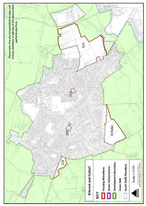
Site reference
213
Village
Bilbrook
Minimum capacity
13 dwellings
Address
Bilbrook House
Site area
0.5ha
Proposed use
Housing
Key requirements
- Any relevant policy requirements including affordable housing, open space, education, health, sports and recreation, energy efficiency, climate change mitigation, flood risk mitigation, highways, sustainable transport, housing mix and green infrastructure, delivered in line with the relevant development plan policy standards.
Proposed access
Provide vehicular and pedestrian access via Carter Avenue
Site reference
224
Village
Codsall
Minimum capacity
85 dwellings
Address
Land adjacent to Station Road
Site area
4.0 ha
Proposed use
Housing
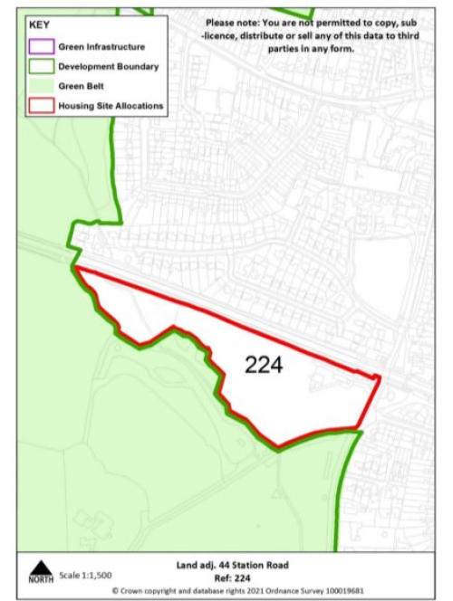
Key requirements
- To deliver a 30 space car park for Codsall railway station
- The tree and hedgerow boundaries that border the site should be retained and enhanced. In particular, the north – western edge of the site to clearly denote the former landscape and current parkland area
- Any relevant policy requirements including affordable housing, open space, education, health, sports and recreation, energy efficiency, climate change mitigation, flood risk mitigation, highways, sustainable transport, housing mix and green infrastructure, delivered in line with the relevant development plan policy standards.
Proposed access
Provide vehicular and pedestrian access via Station Road
Site reference
228
Village
Codsall
Minimum capacity
29 dwellings
Address
Former Adult Training Centre off Histons Hill
Site area
0.8 ha
Proposed use
Housing
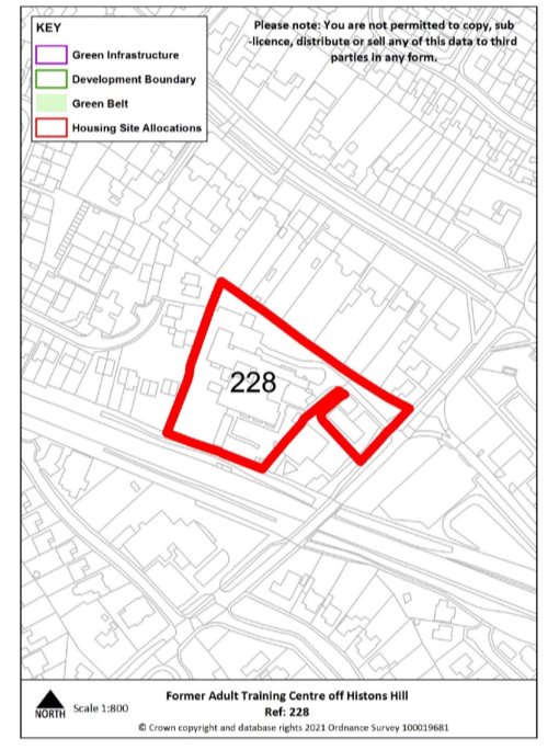
Key requirements
Any relevant policy requirements including affordable housing, open space, education, health, sports and recreation, energy efficiency, climate change mitigation, flood risk mitigation, highways, sustainable transport, housing mix and green infrastructure, delivered in line with the relevant development plan policy standards.
Site reference
419 a&b
Village
Codsall
Minimum capacity
317 dwellings
Address
Land at Keepers Lane & Wergs Hall Rd
Site area
15.1 ha
Proposed use
Housing
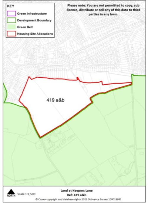
Key requirements
- The tree and hedgerow boundaries that border the site should be retained and where possible enhanced
- Any relevant policy requirements including affordable housing, open space, education, health, sports and recreation, energy efficiency, climate change mitigation, flood risk mitigation, highways, sustainable transport, housing mix and green infrastructure, delivered in line with the relevant development plan policy standards.
Proposed access
Provide vehicular and pedestrian access via Wergs Hall Road and into the adjacent allocated housing site, including provision of a through road from Keepers Lane to Wergs Hall Road and extension of existing footway.
Cheslyn Hay & Great Wyrley
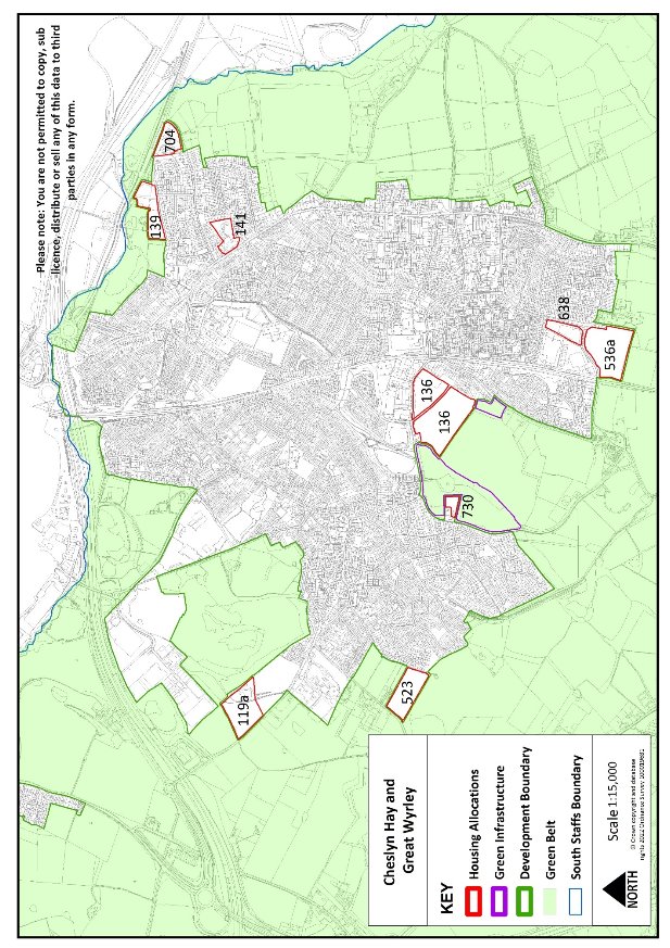
Site reference
119a
Village
Cheslyn Hay
Minimum capacity
60
Address
Land adjoining Saredon Road
Site area
2.9 ha
Proposed use
Housing
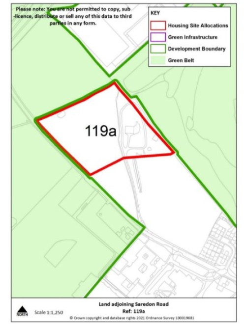
Key requirements
- The tree and hedgerow boundaries that border the site should be retained.
- Any relevant policy requirements including affordable housing, open space, education, health, sports and recreation, energy efficiency, climate change mitigation, flood risk mitigation, highways, sustainable transport, housing mix and green infrastructure, delivered in line with the relevant development plan policy standards.
- Development of the site should be in accordance with the recommendations set out in the Level 2 Strategic Flood Risk Assessment detailed site summary table.
Proposed access
Provide vehicular and pedestrian access via Saredon Road, including extension of footway.
Site Reference
523
Village
Cheslyn Hay
Minimum capacity
49
Address
Land east of Wolverhampton Road
Site area
2.4 ha
Proposed Use
Housing
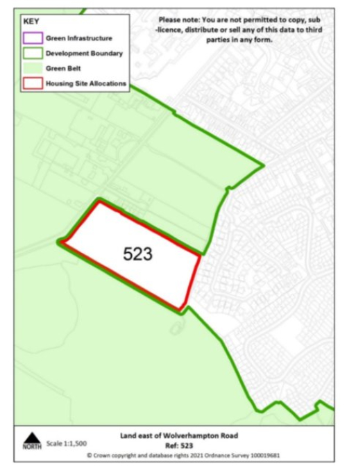
Key requirements
- The tree and hedgerow boundaries that border the site should be retained
- Any relevant policy requirements including affordable housing, open space, education, health, sports and recreation, energy efficiency, climate change mitigation, flood risk mitigation, highways, sustainable transport, housing mix and green infrastructure, delivered in line with the relevant development plan policy standards.
Proposed access
Provide vehicular and pedestrian access via Wolverhampton Road and explore pedestrian access to Pinfold Lane
Site reference
141
Village
Great Wyrley
Minimum capacity
31 dwellings
Address
154a Walsall Road
Site area
1.2 ha
Proposed use
Housing
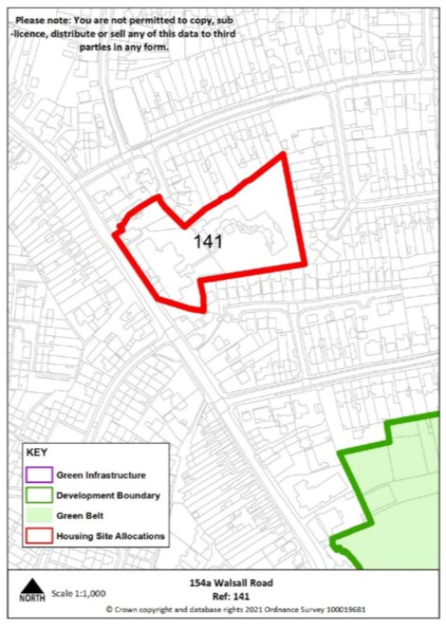
Key infrastructure requirements
Any relevant policy requirements including affordable housing, open space, education, health, sports and recreation, energy efficiency, climate change mitigation, flood risk mitigation, highways, sustainable transport, housing mix and green infrastructure, delivered in line with the relevant development plan policy standards.
Proposed access
Provide vehicular and pedestrian access via Walsall Road.
Site reference
136
Village
Great Wyrley
Minimum capacity
155 dwellings
Address
Land at Landywood Lane
Site area
7.4ha
Proposed use
Housing
F
Key requirements
- To deliver an off-site country park and land for allotments on the adjacent land parcels on the policies map identified as green infrastructure, including display board highlighting the sites mining heritage.
- To deliver parking for Landywood Station
- Create a strong defensible boundary along the south-west edge of the site
- Any relevant policy requirements including affordable housing, open space, education, health, sports and recreation, energy efficiency, climate change mitigation, flood risk mitigation, highways, sustainable transport, housing mix and green infrastructure, delivered in line with the relevant development plan policy standards.
Proposed access
Provide vehicular and pedestrian access via Landywood Lane and Upper Landywood Lane, alongside pedestrian access into new country park.
Site reference
139
Village
Great Wyrley
Minimum capacity
46 dwellings
Address
Pool View, Churchbridge
Site area
2.2 ha
Proposed use
Housing
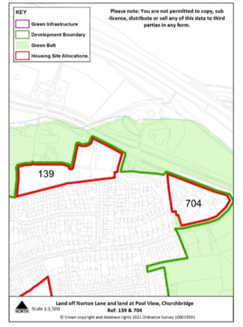
Key requirements
- Wherever possible maintain tree boundaries within the site in line with the HESA – stage 2 (2022) recommendations for the site as they contribute positively to its local distinctiveness and in historic environment terms reflect its former pastoral identity.
- Any relevant policy requirements including affordable housing, open space, education, health, sports and recreation, energy efficiency, climate change mitigation, flood risk mitigation, highways, sustainable transport, housing mix and green infrastructure, delivered in line with the relevant development plan policy standards.
- Development of the site should be in accordance with the recommendations set out in the Level 2 Strategic Flood Risk Assessment detailed site summary table.
Proposed access
Provide vehicular and pedestrian access via Pool View.
Site Reference
704
Village
Great Wyrley
Minimum capacity
31 dwellings
Address
Land off Norton Lane
Site area
1.3 ha
Proposed Use
Housing
Key requirements
Any relevant policy requirements including affordable housing, open space, education, health, sports and recreation, energy efficiency, climate change mitigation, flood risk mitigation, highways, sustainable transport, housing mix and green infrastructure, delivered in line with the relevant development plan policy standards.
Proposed access
Provide vehicular and pedestrian access via Norton Lane, including pedestrian crossing.
Site Reference
730
Village
Great Wyrley
Minimum capacity
10 dwellings
Address
Fishers Farm
Site area
0.3 ha
Proposed Use
Housing
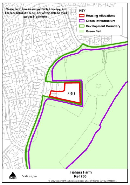
Key requirements
- The boundary to the south of the site should be strengthened through additional planting.
- Any relevant policy requirements including affordable housing, open space, education, health, sports and recreation, energy efficiency, climate change mitigation, flood risk mitigation, highways, sustainable transport, housing mix and green infrastructure, delivered in line with the relevant development plan policy standards.
Proposed access
Provide vehicular and pedestrian access via Upper Landywood Lane.
Site Reference
536a
Village
Great Wyrley
Minimum capacity
84
Address
Land off Holly Lane
Site area
4 ha
Proposed Use
Housing
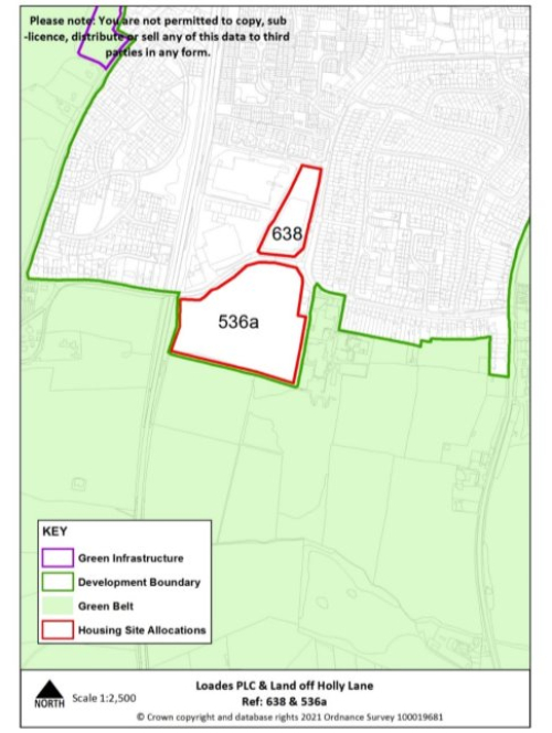
Key infrastructure requirements
- Deliver on site drop off parking to serve Landywood Primary School
- Deliver on site specialist older persons housing
- The tree and hedgerow boundaries that border the site should be retained. In addition, the boundary to the south of the site should be strengthened through additional planting.
- Any relevant policy requirements including affordable housing, open space, education, health, sports and recreation, energy efficiency, climate change mitigation, flood risk mitigation, highways, sustainable transport, housing mix and green infrastructure, delivered in line with the relevant development plan policy standards.
Proposed access
Provide vehicular and pedestrian access via Holly Lane.
Site reference
638
Village
Great Wyrley
Minimum capacity
29
Address
Loades PLC
Site area
1.1 ha
Proposed use
Housing
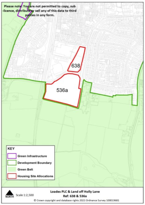
Key requirements
- The tree and hedgerow boundaries that border the site should be retained and where possible enhanced.
- Any relevant policy requirements including affordable housing, open space, education, health, sports and recreation, energy efficiency, climate change mitigation, flood risk mitigation, highways, sustainable transport, housing mix and green infrastructure, delivered in line with the relevant development plan policy standards.
Proposed access
Provide vehicular and pedestrian access via Loades PLC.
Penkridge
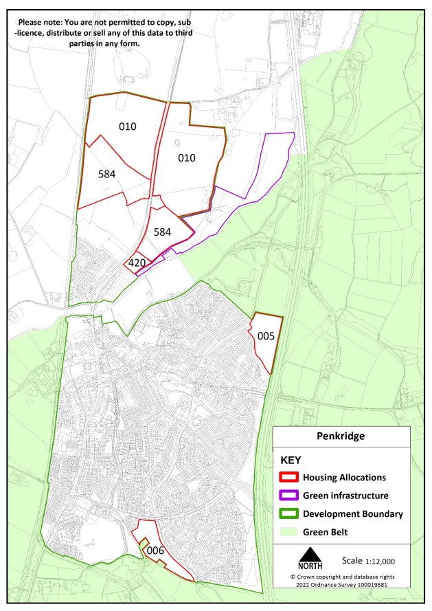
Site reference
005
Village
Penkridge
Minimum capacity
88 dwellings
Address
Land at Cherry Brook
Site area
4.2 ha
Proposed use
Housing
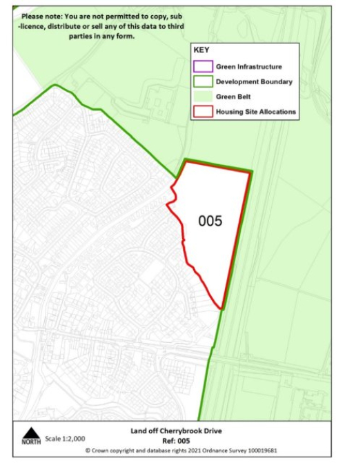
Key requirements
- The tree boundaries on the edge of the site should be retained with the north-western boundary enhanced with additional planting to protect views from the Canal Conservation Area in line with the HESA -stage 2 (2022) recommendations for the site
- Any relevant policy requirements including affordable housing, open space, education, health, sports and recreation, energy efficiency, climate change mitigation, flood risk mitigation, highways, sustainable transport, housing mix and green infrastructure, delivered in line with the relevant development plan policy standards.
Proposed access
Provide vehicular and pedestrian access via Cherrybrook Drive.
Site reference
006
Village
Penkridge
Minimum capacity
80 dwellings
Address
Land at Boscomoor Lane
Site area
3.8 ha
Proposed use
Housing
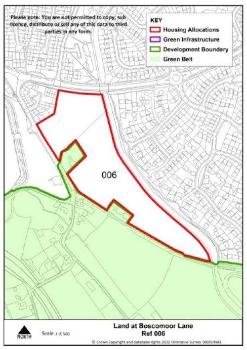
Key requirements
- Existing tree and hedgerow boundaries should be retained and reinforced to protect the Canal Conservation Area and the setting of the local listed Lyne Hill Bridge in line with the HESA – stage 2 (2022) recommendations for the site
- Any relevant policy requirements including affordable housing, open space, education, health, sports and recreation, energy efficiency, climate change mitigation, flood risk mitigation, highways, sustainable transport, housing mix and green infrastructure, delivered in line with the relevant development plan policy standards.
Proposed access
Provide vehicular and pedestrian access via Boscomoor Lane ensuring continuous pedestrian links between the site and Wolgarston Way and connection to the canal towpath.
Tier 2
Brewood
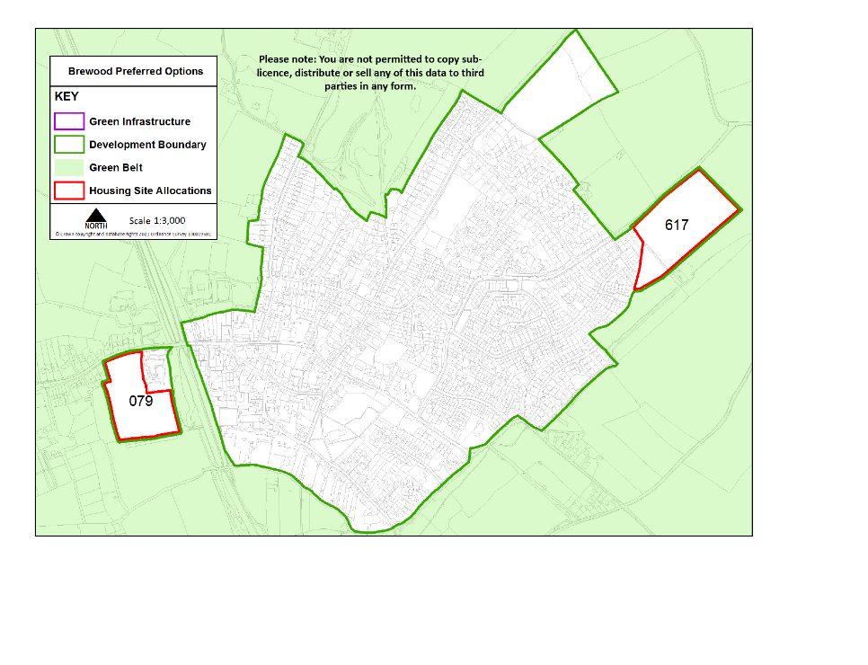
Site reference
079
Village
Brewood
Minimum capacity
43 dwellings
Address
Land south of Kiddemore Green Road
Site area
2.1 ha
Proposed use
Housing (including older persons specialist housing)
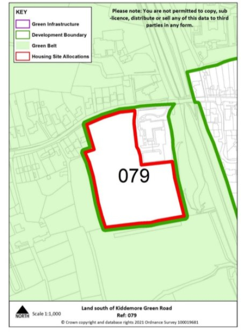
Key requirements
- To deliver on-site specialist older persons housing
- The tree and hedgerow boundaries that border the site should be retained and where possible strengthened.
- Any other relevant development plan requirements including affordable housing, open space, education, health, sports and recreation, energy efficiency, climate change mitigation, flood risk mitigation, highways, sustainable transport, housing mix and green infrastructure.
Proposed access
Provide vehicular and pedestrian access via Kiddemore Green Road, including using existing medical surgery access.
Site reference
617
Village
Brewood
Minimum capacity
63 dwellings
Address
Four Ashes Road
Site area
3 ha
Proposed use
Housing
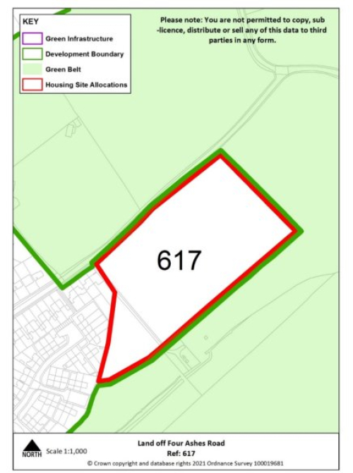
Key requirements
- The tree and hedgerow boundaries that border the site should be retained with additional planting along the east and south eastern edge of the site to create strong defensible boundaries
- Any relevant policy requirements including affordable housing, open space, education, health, sports and recreation, energy efficiency, climate change mitigation, flood risk mitigation, highways, sustainable transport, housing mix and green infrastructure, delivered in line with the relevant development plan policy standards.
- Development of the site should be in accordance with the recommendations set out in the Level 2 Strategic Flood Risk Assessment detailed site summary table.
Proposed access
Provide vehicular and pedestrian access via Four Ashes Road including extension of existing footway.
Huntington
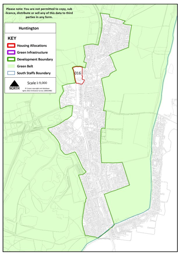
Site Reference
016
Village
Huntington
Minimum capacity
39
Address
Land at Pear Tree Farm
Site area
1.6 ha
Proposed Use
Housing
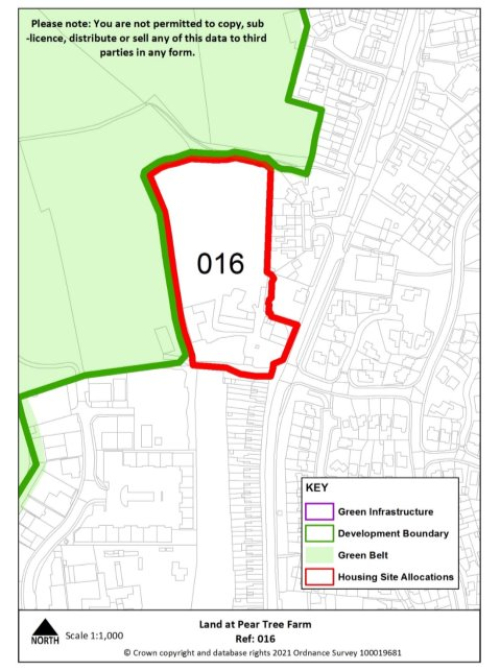
Key requirements
- The tree and hedgerow boundaries that border the site should be retained with the western boundary of the site strengthened through additional planting.
- Any relevant policy requirements including affordable housing, open space, education, health, sports and recreation, energy efficiency, climate change mitigation, flood risk mitigation, highways, sustainable transport, housing mix and green infrastructure, delivered in line with the relevant development plan policy standards.
Proposed access
Provide vehicular and pedestrian access via Stafford Road.
Kinver
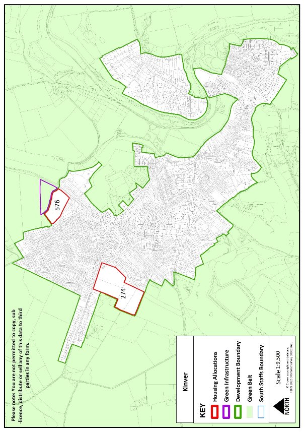
Site reference
274
Village
Kinver
Minimum capacity
Up to 38 dwellings consented on allocated site (20/00621/OUT) alongside minimum 82 dwellings on safeguarded land
Address
Land south of White Hill
Site area
5.5 ha
Proposed use
Housing
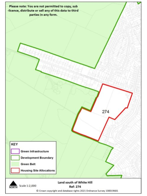
Key requirements
Any relevant policy requirements including affordable housing, open space, education, health, sports and recreation, energy efficiency, climate change mitigation, flood risk mitigation, highways, sustainable transport, housing mix and green infrastructure, delivered in line with the relevant development plan policy standards.
Proposed access
Provide vehicular and pedestrian access via White Hill.
Site reference
576
Village
Kinver
Minimum capacity
44 dwellings
Address
Land off Hyde Lane (west)
Site area
2 ha
Proposed Use
Housing
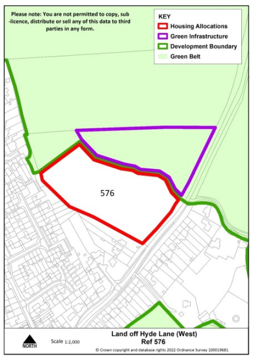
Key requirements
- Create strong defensible boundaries along the north and western edges of the site with additional planting
- Any relevant policy requirements including affordable housing, open space, education, health, sports and recreation, energy efficiency, climate change mitigation, flood risk mitigation, highways, sustainable transport, housing mix and green infrastructure, delivered in line with the relevant development plan policy standards.
Proposed access
Provide vehicular and pedestrian access via Hyde Lane, including extension of existing footway.
Perton
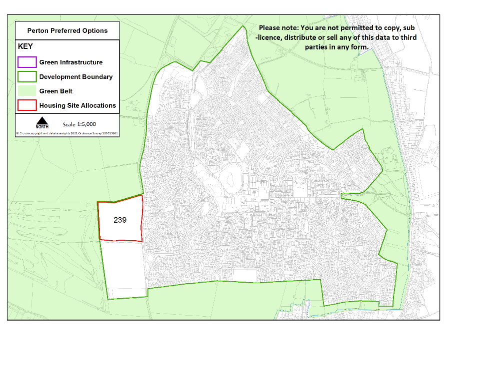
Site reference
239
Village
Perton
Minimum capacity
150 dwellings
Address
Land west of Wrottesley Park Road (south)
Site area
7.2 ha
Proposed use
Housing
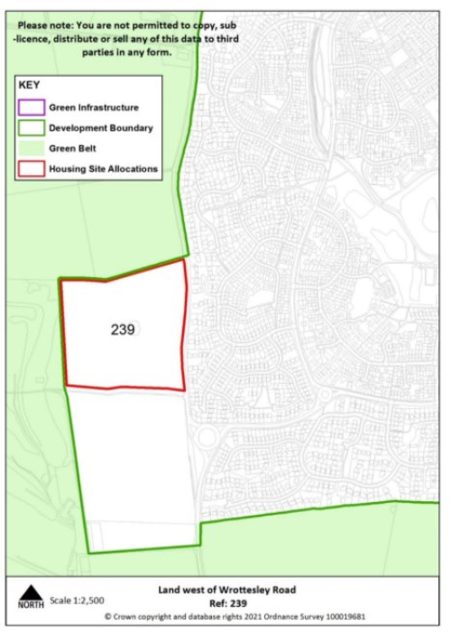
Key requirements
- The tree and hedgerow boundaries that border the site should be retained with the boundary on the northern edge of the site strengthened
- Any relevant policy requirements including affordable housing, open space, education, health, sports and recreation, energy efficiency, climate change mitigation, flood risk mitigation, highways, sustainable transport, housing mix and green infrastructure, delivered in line with the relevant development plan policy standards.
Proposed access
Provide vehicular and pedestrian access via Wrottesley Park Road and pedestrian access into neighbouring allocated site.
Wombourne
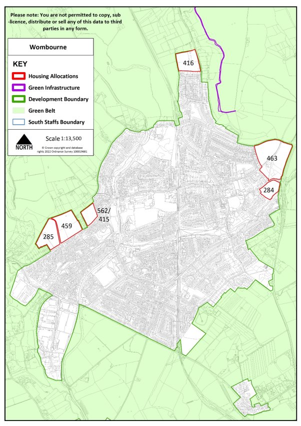
Site Reference
416/416a
Village
Wombourne
Minimum capacity
79 dwellings
Address
Land off Orton Lane
Site area
3.6ha
Proposed Use
Housing
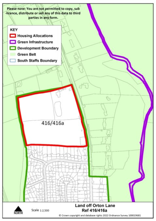
Key requirements
- Ensure sites 416 and 416a are planned and delivered as a single site
- Any relevant policy requirements including affordable housing, open space, education, health, sports and recreation, energy efficiency, climate change mitigation, flood risk mitigation, highways, sustainable transport, housing mix and green infrastructure, delivered in line with the relevant development plan policy standards.
Proposed access
Provide vehicular and pedestrian access via Orton Lane, including extension of existing footway.
Site reference
285
Village
Wombourne
Minimum capacity
82 dwellings
Address
Land off Pool House Road
Site area
3.9 ha
Proposed use
Housing
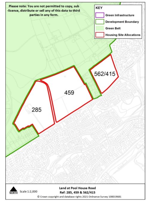
Key requirements
- Provide highway and pedestrian connectivity to site 459.
- Any relevant policy requirements including affordable housing, open space, education, health, sports and recreation, energy efficiency, climate change mitigation, flood risk mitigation, highways, sustainable transport, housing mix and green infrastructure, delivered in line with the relevant development plan policy standards.
Proposed access
Provide vehicular and pedestrian access via Pool House Road alongside pedestrian links to the village centre along Ounsdale Road.
Site reference
562/415
Village
Wombourne
Minimum capacity
44 dwellings
Address
Land off Pool House Road
Site area
1.9 ha
Proposed use
Housing
Key requirements
- The tree and hedgerow boundaries that border the site should be retained with the boundary on the northern edge strengthened.
- Any relevant policy requirements including affordable housing, open space, education, health, sports and recreation, energy efficiency, climate change mitigation, flood risk mitigation, highways, sustainable transport, housing mix and green infrastructure, delivered in line with the relevant development plan policy standards.
Proposed access
Provide vehicular and pedestrian access via Pool House Road alongside pedestrian links to the village centre along Ounsdale Road.
Site reference
459
Village
Wombourne
Minimum capacity
97 dwellings
Address
Land off Pool House Road
Site area
4.6 ha
Proposed use
Housing

Key requirements
- The tree and hedgerow boundaries that border the site should be retained with the boundary on the northern edge strengthened.
- Provide highway and pedestrian connectivity to site 285.
- Any relevant policy requirements including affordable housing, open space, education, health, sports and recreation, energy efficiency, climate change mitigation, flood risk mitigation, highways, sustainable transport, housing mix and green infrastructure, delivered in line with the relevant development plan policy standards.
Proposed access
Provide vehicular and pedestrian access via Pool House Road alongside pedestrian links to the village centre along Ounsdale Road.
Site reference
463 & 284
Village
Wombourne
Minimum capacity
223 dwellings
Address
Land off Billy Buns Lane & Gilbert Lane
Site area
10.6 ha
Proposed use
Housing
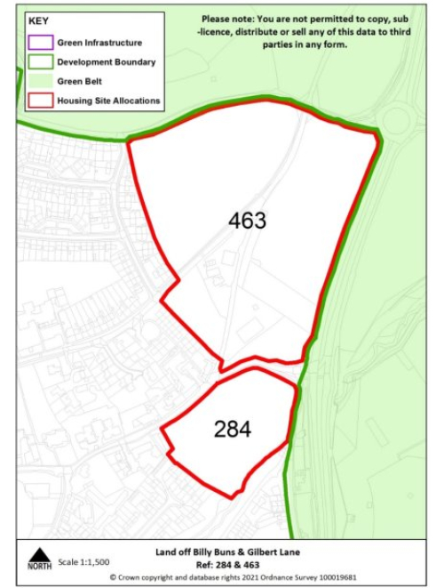
Key requirements
- The tree and hedgerow boundaries that border the site should be retained as far as possible.
- Any relevant policy requirements including affordable housing, open space, education, health, sports and recreation, energy efficiency, climate change mitigation, flood risk mitigation, highways, sustainable transport, housing mix and green infrastructure, delivered in line with the relevant development plan policy standards.
- Development of the site should be in accordance with the recommendations set out in the Level 2 Strategic Flood Risk Assessment detailed site summary table.
Proposed access
Provide vehicular and pedestrian access via Billy Buns Lane, High Street and School Road, including extensions of existing footways.
Tier 3
Coven
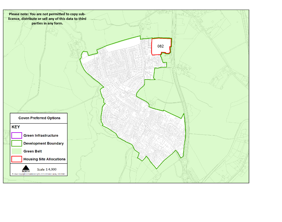
Site reference
082
Village
Coven
Minimum capacity
48 dwellings
Address
Land between A449 Stafford Road & School Lane
Site area
2.3 ha
Proposed use
Housing
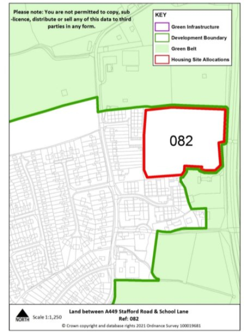
Key infrastructure requirements
- The tree and hedgerow boundaries that border the site should be retained
- Any relevant policy requirements including affordable housing, open space, education, health, sports and recreation, energy efficiency, climate change mitigation, flood risk mitigation, highways, sustainable transport, housing mix and green infrastructure, delivered in line with the relevant development plan policy standards.
Proposed access
Provide vehicular and pedestrian access via the playing fields of School Lane.
Featherstone
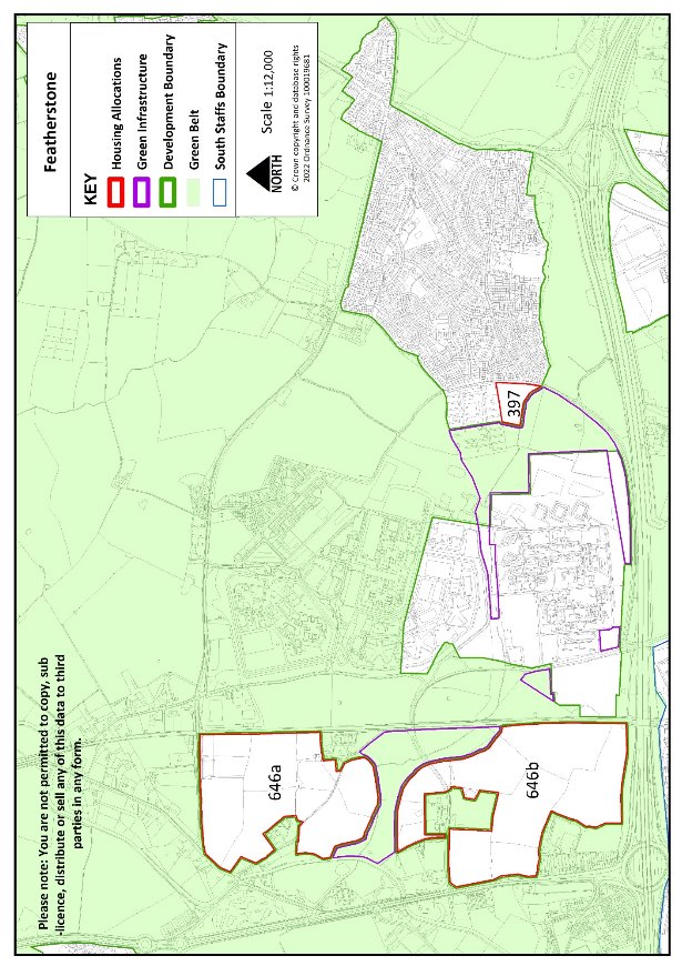
Site Reference
397
Village
Featherstone
Minimum capacity
35 dwellings
Address
Land adj. to Brookhouse Lane
Site area
1.6 ha
Proposed Use
Housing
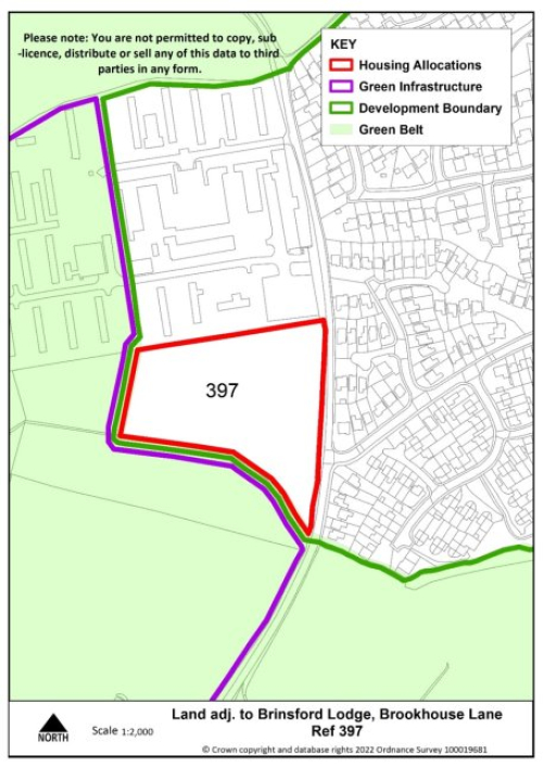
Key requirements
- Landscaping along the sites southern boundary to enhance the landscape character of the stream.
- Any relevant policy requirements including affordable housing, open space, education, health, sports and recreation, energy efficiency, climate change mitigation, flood risk mitigation, highways, sustainable transport, housing mix and green infrastructure, delivered in line with the relevant development plan policy standards.
Proposed access
Provide vehicular and pedestrian access via Malayan Way and into allocated site to the north.
Pattingham
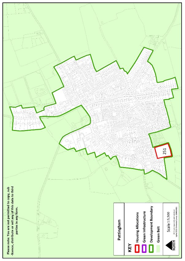
Site Reference
251
Village
Pattingham
Minimum capacity
17 dwellings
Address
Hall End Farm
Site area
0.8 ha
Proposed Use
Housing
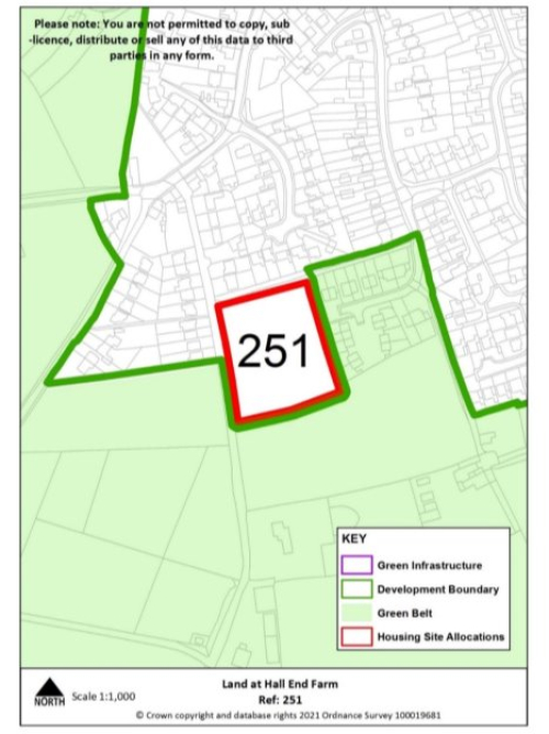
Key requirements
- The tree and hedgerow boundaries that border the site should be retained with the boundary along the southern edge of the site strengthened
- Any relevant development plan policy requirements including affordable housing, open space, education, health, sports and recreation, energy efficiency, climate change mitigation, flood risk mitigation, highways, sustainable transport, housing mix and green infrastructure, delivered in line with the relevant development plan policy standards.
Proposed access
Provide vehicular and pedestrian access to public highway via the adjacent rural exception site to the east
Swindon
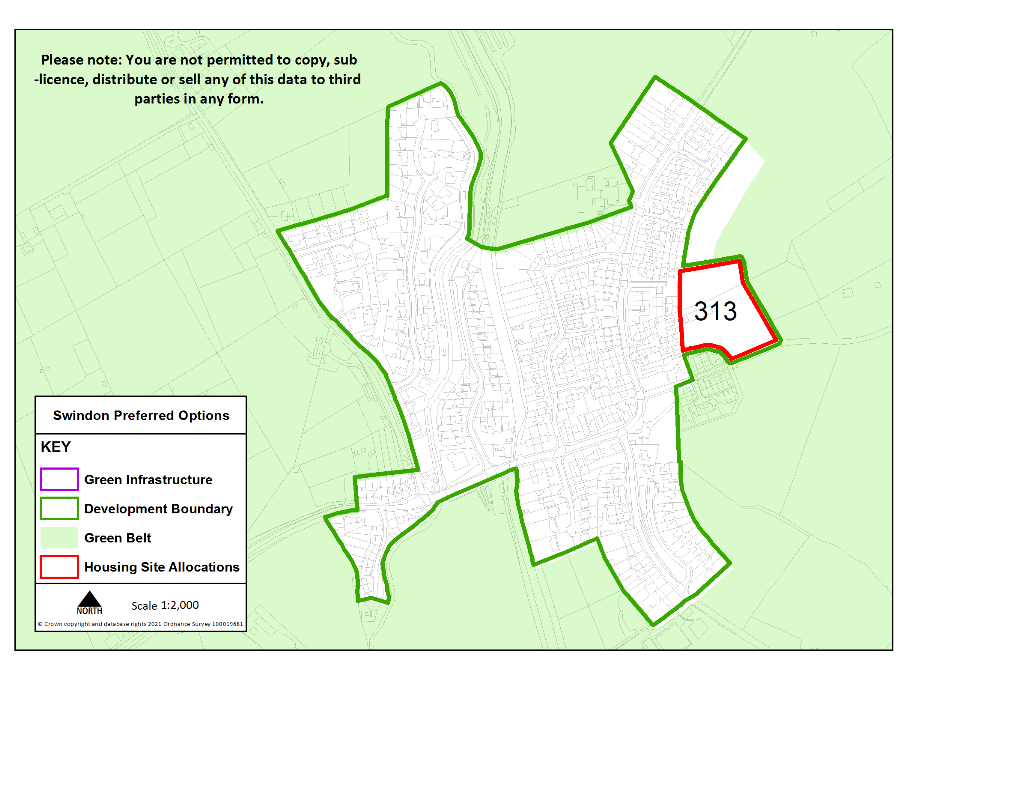
Site Reference
313
Village
Swindon
Minimum capacity
22 dwellings
Address
Land off Himley Lane
Site area
1 ha
Proposed Use
Housing
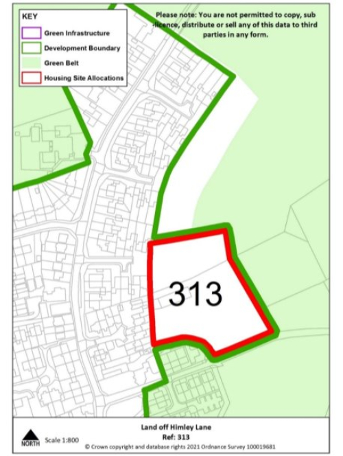
Key requirements
- The tree and hedgerow boundaries that border the site should be retained with defensible boundaries established along the eastern and northern edges of the site.
- Any relevant development plan policy requirements including affordable housing, open space, education, health, sports and recreation, energy efficiency, climate change mitigation, flood risk mitigation, highways, sustainable transport, housing mix and green infrastructure, delivered in line with the relevant development plan policy standards.
Proposed access
Provide vehicular and pedestrian access via Himley Lane, including footway link to wider village.
Wheaton Aston
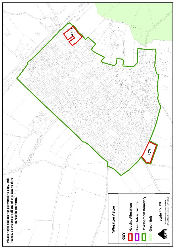
Site reference
379
Village
Wheaton Aston
Minimum capacity
18 dwellings
Address
Land off Ivetsey Road
Site area
0.8 ha
Proposed use
Housing
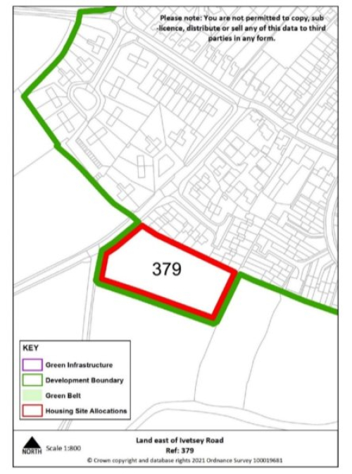
Key requirements
- A strong defensible boundary should be established along the southern edge of the site through additional planting.
- The hedge boundaries on the site should be retained as far as possible in line with the HESA - stage 2 (2022) requirements as they contribute positively to its local distinctiveness and in historic environment terms, reflect its former pastoral identity
- Any relevant policy requirements including affordable housing, open space, education, health, sports and recreation, energy efficiency, climate change mitigation, flood risk mitigation, highways, sustainable transport, housing mix and green infrastructure, delivered in line with the relevant development plan policy standards.
Proposed access
Provide vehicular and pedestrian access via Ivetsey Road, including extension of existing footway.
Site reference
426a
Village
Wheaton Aston
Minimum capacity
15 dwellings
Address
Bridge Farm: 54 Long Street
Site area
0.6 ha
Proposed use
Housing
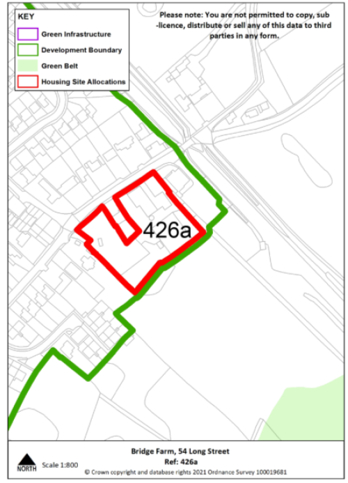
Key requirements
- Development will need to be sensitively designed in line with the HESA – stage 2 (2022) recommendations reflecting its proximity to the Canal Conservation Area.
- The south-eastern boundary of the site should be strengthened through additional planting
- Any relevant development plan policy requirements including affordable housing, open space, education, health, sports and recreation, energy efficiency, climate change mitigation, flood risk mitigation, highways, sustainable transport, housing mix and green infrastructure, delivered in line with the relevant development plan policy standards.
Proposed access
Provide vehicular and pedestrian access via Long Street.
Urban Extensions to Neighbouring Towns and Cities
South of Stafford
Site reference
036c
Village
South of Stafford
Minimum capacity
81 dwellings
Address
Land at Weeping Cross (adjoining Stafford Borough boundary)
Site area
3.85ha
Proposed use
Housing
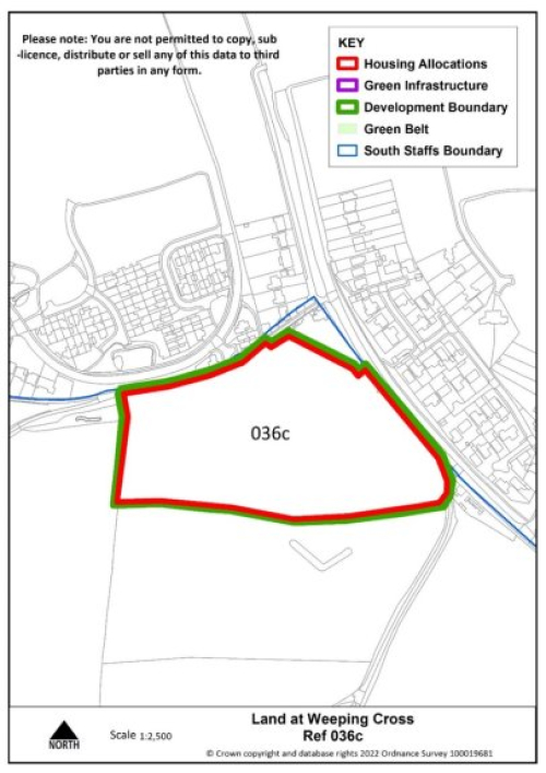
Site requirements
- The tree and hedgerow boundaries that border the site should be retained with the boundaries to the west and south of the site strengthened to create strong defensible boundaries.
- Any relevant policy requirements including affordable housing, open space, education, health, sports and recreation, energy efficiency, climate change mitigation, flood risk mitigation, highways, sustainable transport, housing mix and green infrastructure, delivered in line with the relevant development plan policy standards.
Proposed access
Provide vehicular and pedestrian access via Cannock Road (A34).
West of Wolverhampton
Site reference
582
Village
West of Wolverhampton
Minimum capacity
390 dwellings
Address
North of Langley Road (adjoining City of Wolverhampton boundary)
Site size
18.6 ha
Proposed use
Housing
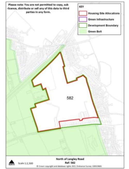
Site requirements
- In line with the HESA stage 2 (2022) recommendations for the site, no development works should be undertaken within the extent of the Second World War gun battery site, and it may be suitable as public open space (subject to health and safety). The tree and hedgerow boundaries that border the site should be retained in keeping with the landscape character and providing definition between any proposed development and the Staffordshire Railway Walk.
- Any other relevant policy requirements including affordable housing, open space, education, health, sports and recreation, energy efficiency, climate change mitigation, flood risk mitigation, highways, sustainable transport, housing mix and green infrastructure, delivered in line with the relevant development plan policy standards.
- Provide high quality walking and cycling access for the site along the Langley Road to the Merry Hill centre.
Proposed access
Provide vehicular and pedestrian access via Langley Road. Explore potential for direct pedestrian links north to Castlecroft Road and onto adjacent railway walk.


