Publication Plan November 2022
Part B: Site Allocations
6. Site Allocations
Housing
(3) 6.1 Following consultation on the Spatial Housing Strategy and Infrastructure Delivery (SHSID) consultation in October 2019, site assessments were undertaken using the site assessment criteria consulted on. All sites at tier 1-4 settlements and other locations identified in the council's preferred spatial option for growth (Option G) were assessed.
(1) 6.2 Following assessment of sites, the results of these, alongside responses to the consultation, were considered together to determine where amendments to the preferred spatial strategy were justified. This entailed considering a balance of top-down strategic factors and bottom-up site-specific factors, which are shown in the diagram below:
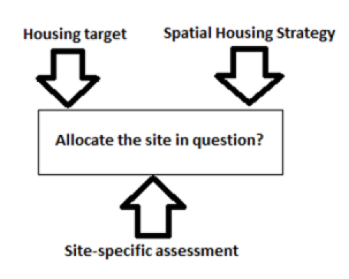
(1) 6.3 This assessment process led to preferred sites being identified to deliver the updated spatial strategy set out in the Preferred Options Local Plan, which was subject to consultation in November 2021. Following this consultation, a number of additional amendments to sites were made having regard to representations received to the Preferred Options, including identification of three additional small brownfield sites and removal of sites where updated evidence or information from statutory bodies suggested they were unsuitable. The full methodology, factors considered, and results of the site assessment process for all site options can be found in our Housing Site Assessment Topic Paper.
(6) 6.4 The site selection process has identified proposed sites to meet our revised infrastructure led strategy between 2018-39, ensuring enough housing land is identified to meet the council's housing target of 9,089 dwellings between 2018 and 2039, whilst providing extra land to ensure the plan is flexible to changing circumstances. Where possible, the likely infrastructure requirements for both large scale and smaller housing sites have been identified through engagement with infrastructure providers and site promoters. These are set out in Policies SA1-SA4 and Appendix B for the district's largest site proposals, and in Policy SA5 and Appendix C for the small to medium sized site proposals. Further details on the delivery of these infrastructure items (e.g. estimated costs, timescales for delivery) are set out in the Infrastructure Delivery Plan (2022).
6.5 Where more non-standard infrastructure requirements are proposed and are not reflected in the standard site typologies in the Local Plan Viability Study (2022) then these sites have been subject to site specific viability assessments to confirm the necessary infrastructure is deliverable alongside policy requirements with an associated cost set out in this Local Plan.
Strategic Master Plan Locations
6.6 A significant amount of housing growth in South Staffordshire up to 2039 will be delivered by four key strategic sites, which have been identified through the site selection process. It is important to properly masterplan sites of this scale, which need to be supported by appropriate new infrastructure and will significantly change the character of the area for years to come. To support this, the council has prepared an indicative concept plan, vision and objectives for each site, which have been prepared in collaboration with the site promoters, stakeholders and infrastructure providers. These will form the basis for more comprehensive masterplans and design codes that will be required as part of the planning process, prepared in collaboration with the council and local communities.
6.7 These master plans will need to be developed for each site in line with the requirements set out in Policy MA1. The plan also includes site specific policies (SA1-SA4) for each strategic site that detail a number of site-specific requirements that will need to be incorporated through the iterative process of developing the strategic master plans.
(11) Policy MA1 – Masterplanning Strategic Sites
The council considers high quality design to be a key component of achieving sustainable development and will support new development where it is well designed, located and responsive to local context.
A comprehensive and deliverable site-wide Strategic Master Plan (SMP) for each of the strategic sites set out in Policies SA1 – SA4 will be prepared by the landowners/promoters, in conjunction with and to be approved by the council. The scope and contents of the site-wide Master Plans will be confirmed by the council in pre-application discussions and will be based upon and informed by community and stakeholder engagement and the relevant site-specific vision, objectives and concept plan as set out in Policies SA1 – SA4, to ensure that development for the whole site is delivered in a comprehensive and co-ordinated manner and is of sufficient quality. The site-wide Master Plans will be a material consideration in the determination of future planning applications related to the relevant site(s) and adherence to it/them will be secured through relevant planning conditions and/or legal agreement. The SMP will include the following:
Development proposals should be consistent with other Local Plan policies.
- Vision and Objectives based on the content of the relevant strategic site policy as set out below, with any further iteration/update following further consultation and technical evidence
- Baseline Evidence setting out the key constraints and opportunities in relation to the site and reference to relevant supporting technical documentation.
- Land Use Framework addressing the key broad extent, type and mix of development uses across the site (including any public open space)
- Movement Framework and Access Strategy including:
- a clear route hierarchy of primary and secondary streets, pedestrian and cycle routes which plug into existing and proposed networks and key destinations within and beyond the site boundary
- potential bus circulation routes and bus stops (including service diversion where appropriate and infrastructure considerations for electric bus provision)
- Green Infrastructure Framework including:
- A clear hierarchy of public open space throughout the site, including indicative roles and functions of different spaces (e.g. play, biodiversity/natural capital, SuDS, recreation)
- Indicative ecological mitigation and opportunities for delivering biodiversity net gain on the site
- Opportunities to integrate SuDS within the site's green infrastructure
- Areas for allotments/community gardens/forest schools etc. (informed by engagement with local community/Parish Council)
- Utilisation and retention of existing landscape features and key views into and out of the site to create a distinctive and visually sensitive character to the development that links into the green infrastructure network beyond the site's boundaries
- Urban Design Framework creating a cohesive urban structure for the site including:
- Character areas
- Gateways, landmarks, key views and nodes
- Community hubs
- Important frontages
- Sensitive areas
- Comprehensive Spatial Framework Plan drawing together the above frameworks to demonstrate the overall placemaking strategy for the site
- Development Phasing and Delivery Strategy collating information regarding the phasing and delivery of the following items:
- On and offsite highways mitigation
- Public transport provision
- Active travel links
- On and offsite education provision
- Open space, biodiversity / habitat mitigation and enhancement and other green infrastructure (e.g. playing fields/allotments)
- Flood risk mitigation, drainage and SuDS infrastructure
- Sports and recreation facilities
- Community facilities
- Utilities
- Affordable housing provision
- Planning strategy setting out the expectations for future planning applications
- A strategy for site wide Design Coding: setting out the approach to formulating provably popular site wide and area (as appropriate) design coding, in keeping with the requirements of the National Model Design Code and accompanying National Model Design Guidance.
- Community and key stakeholder consultation/engagement strategy and outcomes for the site setting out who has been engaged, in what way and how this has informed the SMP
- A site-specific infrastructure delivery schedule setting out broad timing and triggers for the delivery of critical infrastructure to deliver comprehensive and co-ordinated placemaking
Implementation
|
Local/national Funding |
Development Management |
Partners |
Section 106/278 agreement |
Masterplan framework |
|
No |
Yes |
Yes |
Yes |
Yes |
Land East of Bilbrook
6.8 A strategic site has been identified to the East of Bilbrook, reflecting the area's public transport infrastructure, proximity to employment opportunities and the services and facilities available in the wider Codsall/Bilbrook area. Policy SA1 and the Vision and Objectives for the site aim to respond to the site's context and key requirements to ensure a high quality, sustainable new neighbourhood is created.
(40) Policy SA1 – Strategic development location: Land East of Bilbrook
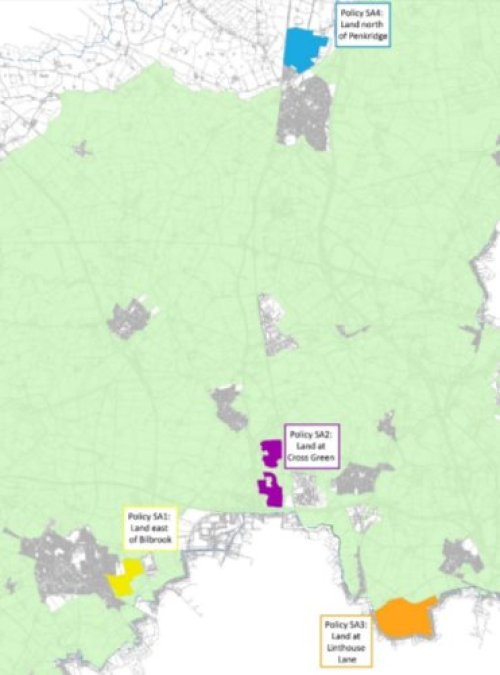
A strategic site for major housing growth is identified at Land East of Bilbrook in the location shown in Appendix B of this document. The key spatial principles for delivering this level of housing growth at Land East of Bilbrook are illustrated through the indicative Concept Plan for the site shown in Appendix F. The development should be delivered in accordance with the requirements of other policies in this Local Plan and an approved site wide Strategic Master Plan as required under Policy MA1, consistent with the Concept Plan, vision and objectives for the site contained within this document and requirements set out within the Infrastructure Delivery Plan. The site-specific requirements should include:
- A minimum of 848 new homes;
- Affordable housing and a specialist elderly housing element (e.g. sheltered or extra care) of at least 40 units in accordance with other policies within the local plan;
- A Community Hub focused around a central area of communal green space, well connected to the site wide green infrastructure network, to contain:
- Small local convenience retail to serve the day to day needs of the neighbourhood
- Flexible community space
- A new First School (1.3ha)
- Vehicular accesses onto Pendeford Mill Lane, Lane Green Road and Barnhurst Lane and appropriate public transport provision to support sustainable travel from the scheme;
- High quality active travel links through and beyond the site, including to the recreational green space to the north, local shops and rail station in Bilbrook and the Sustrans network to the east;
- A network of green and blue infrastructure consistent with the indicative layout on the Concept Plan, providing for high quality Sustainable Drainage Systems, open space, play, biodiversity net gain and active travel, including a large central green space at the heart of the development and additional compensatory Green Belt improvements on the land identified as off -site green infrastructure to the south of the site in accordance with Policy DS2;
- Enhancement of and provision of additional playing pitches and associated facilities in the existing recreational open space to the north of Pendeford Mill Lane, including improved active travel links from the new neighbourhood;
- Any necessary historic environment mitigation identified in the council's Historic Environment Site Assessment Stage 2 (2022), including setting back development from the site's eastern edge and reinforcing planting within that boundary; and
- Necessary contributions towards offsite infrastructure, including highways and active travel mitigation measures, education, leisure and health provision.
- Development of the site should be in accordance with the recommendations set out in the Level 2 Strategic Flood Risk Assessment detailed site summary table.
Development proposals should be consistent with other Local Plan policies.
Vision
(1) 6.9 Land East of Bilbrook will create the new arrival point into the existing settlement of Bilbrook, providing a distinctive and attractive gateway and sensitive edge to the countryside. It will be a sustainable, well-connected neighbourhood for Bilbrook, centred around a new first school together with flexible community/employment space, potential convenience shopping and a central green, with residents having excellent sustainable links to existing facilities and employment opportunities, such as the shops/amenities on Bilbrook Road, the nearby train station, the enhanced Bilbrook playing fields and i54. The new neighbourhood will have a diverse character, focussed around new and existing green and blue infrastructure, with green corridors and effective flood management creating a network of multi-functional communal space. The homes will be highly energy efficient and sustainable, providing a variety of styles and accommodation to suit a range of established needs. The development will focus on achieving high environmental standards, energy efficiency and a regulated net zero carbon community.
Objectives
Transport & Movement
- The new neighbourhood will contain a network of connected tree-lined streets, with strong cycling and walking routes within the site. This network will be well-connected through multiple access points to the surrounding area, including convenient access to sustainable travel infrastructure and key off site walking/cycling routes, such as the i54 Sustrans route 81 (A National Cycling Network protected route) and nearby Bilbrook train station.
Housing & Built Environment
- The new neighbourhood will contain a number of character areas, drawing inspiration from relevant smaller historic village cores in the surrounding area and responding positively and relating well to the site surroundings, such as the canal corridor, street hierarchy, greenspace to the south, countryside edge to the north and existing urban grain of Lane Green Road etc. There will be a variety and mix of house types to accommodate a range of people including first time buyers, young families and elderly persons, with a focus on high environmental standards, energy efficiency and a move towards a net zero carbon community.
Active, Inclusive and Safe - A range of suitable homes will be provided to meet established needs in respect of size, type, tenure and affordability in order to realise a balanced community.
Environmentally Sensitive - New safe and attractive walking and cycling routes will be provided that link to existing, nearby green and sustainable routes, such as the canal corridor, and the Sustrans route 81 and to the existing Bilbrook playing fields. Existing ecological features such as hedgerows will be maintained and wildlife habitat enhanced as part of the creation of high quality Sustainable Drainage Systems (SuDS), that align with the new greenspace and green routes to create multi-functional amenity spaces and biodiversity corridors. A central green space will be created to form the heart of the neighbourhood and tree lined boulevards will create and attractive main route and promote biodiversity.
(1) 6.11 Social and Economic
Well served
- A new first school will be provided in a central location, adjacent the green space and accessible by walking and cycling as well as by motor vehicles. This will create a focal point for the neighbourhood, where other flexible space for community/local employment uses could be introduced. A small local supermarket in the new neighbourhood could be provided to cater for local needs, with good walking and cycling links provided to Pendeford Mill Lane and Lane Green Road, enabling access to Bilbrook village centre.
Thriving: - The new neighbourhood is located within easy reach of local businesses, i54 and Wolverhampton City Centre, where employment opportunities exist. The scheme will connect with and contribute towards the improvement of sustainable transport links to both key employment locations.
Well run: - The existing and new residents within the community should be engaged to consider the future stewardship of the place and in particular the design, delivery and future management of the new facilities such as the neighbourhood centre/community space and green infrastructure network, including the potential for a future Community Trust to be established.
Implementation
|
Local/national Funding |
Development Management |
Partners |
Section 106/278 agreement |
Masterplan framework |
|
No |
Yes |
Yes |
Yes |
Yes |
Land at Cross Green
(1) 6.12 A strategic site has been identified just north of the Black Country's urban area at Cross Green, reflecting the area's proximity to employment opportunities and the Black Country urban area as well as the potential for the longer-term delivery of a rail-based parkway station to be supported by development in this location. Policy SA2 and the Vision and Objectives for the site aim to respond to the site's context and key requirements to ensure a high quality, sustainable new village is created.
(29) Policy SA2 – Strategic development location: Land at Cross Green
A strategic site for major housing growth is identified at Land at Cross Green as shown in Appendix B of this document. The key spatial principles for delivering this level of housing growth at Land at Cross Green are illustrated through the indicative Concept Plan for the site shown in Appendix F. The development should be delivered in accordance with the requirements of other policies in this Local Plan and an approved site wide Strategic Master Plan, as required under Policy MA1, consistent with the Concept Plan, vision and objectives for the site contained within this document and the requirements of the Infrastructure Delivery Plan. The site-specific requirements should include:
- A minimum of 1,200 homes
- Affordable housing and a specialist elderly housing element (e.g. sheltered or extra care) of at least 40 units in accordance with other policies within the local plan;
- A community hub/village centre, focused around a central area of communal greenspace. in close proximity to the new parkway station and well-connected to the site-wide green infrastructure network, to contain:
- Convenience retail provision to meet the needs of the new village and the nearby communities of Coven Heath, Coven and Cross Green
- Other commercial floorspace to support day to day needs of the village and nearby communities
- A local employment hub/space
- Flexible community space.
- A transport/movement strategy which includes access onto the A449, Brinsford Lane, New Road/Old Stafford Road and to the ROF Featherstone employment site to the east and appropriate public transport provision to support sustainable travel from the scheme;
- High quality active travel links through and beyond the site, including to the cycleway running along the A449, the nearby canal towpath network, the ROF strategic employment site and throughout the site to connect all neighbourhoods to the new community facilities at its centre;
- Safeguarded land which could feasibly deliver a future rail-based park and ride, comprising of a 2 platform station and 500 car parking spaces, in the broad location shown on the Concept Plan
- A network of green and blue infrastructure consistent with the indicative layout on the Concept Plan, providing for high quality Sustainable Drainage Systems, open space, sport, biodiversity net gain and active travel, including an integrated and connected green network running through the development, a central communal green space and additional compensatory Green Belt improvements at the heart of the site in accordance with Policy DS2;
- The provision of full-size sports pitches to national standard along with associated facilities to meet identified need. This should be explored further as part of the site wide masterplan process, including the potential to implement any alternative suitable strategy to meet identified needs.
- A new Primary/First School (1.6ha);
- Any necessary historic environment mitigation identified in the council's Historic Environment Site Assessment Stage 2 (2022), including preserving and potentially enhancing existing tree and hedge boundaries along Dark Lane and undertaking geophysical surveys of the northern and eastern part of the site prior to submission of a planning application; and
- Necessary contributions towards offsite infrastructure, including highways and active travel mitigation measures, education, leisure and health provision.
- Development of the site should be in accordance with the recommendations set out in the Level 2 Strategic Flood Risk Assessment detailed site summary table.
Development proposals should be consistent with other Local Plan policies.
Vision
(2) 6.13 Land at Cross Green will be a thriving, sustainable and beautiful modern Staffordshire village. It will be landscape led and deliver high quality, distinctive development respecting and enhancing the area's existing natural assets, landscape and key views.
(1) 6.14 The development will be relatively self-contained and provide a balance of environmental, economic and social opportunities for future residents, whilst complimenting and meeting the needs of the existing nearby communities. There will be a new neighbourhood centre and community park at its heart, delivering new space for community, retail and local business/employment opportunities. The new homes and facilities will increase the range of opportunities for existing and future residents.
(1) 6.15 The development will be well-connected to the existing network of public rights of way, footways and highways and the surrounding countryside with improved public transport, cycling and walking links. The connections will enhance access to nearby employment opportunities and to future public transport, including a new rail station which will provide an integrated local transport hub. The design and layout of the development will encourage and enable sustainable movement, encouraging active travel to services and facilities, including the new neighbourhood centre, rail station and community facilities, within a framework of walkable neighbourhoods, utilising a clear hierarchy of streets and new greenways.
6.16 High quality and distinctive design, integrated within a green and blue infrastructure framework, extending throughout and beyond the new development, will deliver a strong sense of place and identity. The development will focus on achieving high environmental standards, energy efficiency and a regulated net zero carbon community.
Objectives
(1) 6.17 Environmental
Transport & Movement
- The new settlement will be permeable and prioritise active travel and walkable neighbourhoods, with a safe and secure hierarchy of connected streets and routes including strong cycling and walking infrastructure throughout the site and beyond.
- Connections with and improvements to sustainable travel infrastructure such as the new rail station and the local footpath and cycleways will be prioritised and provided.
- Streets will be tree lined where relevant and all streets should be connected, safe and secure as part of an overall site wide movement framework.
Housing & Built Environment
- Defined character areas will be created within the site (e.g. Canal Basin area; sensitive edges; neighbourhood centre; community park), seeking to respond to the existing physical surroundings/context of the site and the movement framework/hierarchy.
- Provide a high quality, well-designed and innovative housing mix to create a balanced community and accommodate a range of people from first time buyers, young families and the elderly.
- The development will include a variety of building forms relevant to specific character areas but will not be high rise. Buildings should be well insulated and energy efficient with potential to utilise modern methods of construction and provide opportunities for self-build.
Environmentally Sensitive
- A high-quality site wide network of integrated green infrastructure, including existing environmental assets, natural capital corridors and SuDS, will enable connectivity and sustainable movement, mitigate and utilise flood zones and contribute to a 10% net gain in biodiversity.
- Tree lined streets will be provided to soften hard infrastructure and promote biodiversity corridors and hubs throughout the settlement.
- A new community park will be provided at the heart of the new settlement and connected to the wider green infrastructure and movement framework.
Well Served and Thriving
- The provision of a new neighbourhood centre will be provided centrally to the development to accommodate relevant facilities/services for the new settlement and existing nearby communities to include local retail, flexible community space and local employment.
- Provide new residents with excellent active travel links to key strategic employment sites (ROF Featherstone, I54)
- A new primary school will also be provided at the heart of the development to ensure it is accessible by all.
- The new neighbourhood centre will form a positive relationship with the new rail station in respect of mutual services, amenities and parking.
(1) 6.19 Social
Active, Inclusive and Safe
- Active travel will be prioritised throughout the settlement to encourage walking/cycling whilst also reducing the risk of air pollution from traffic within the site.
- A range of suitable homes will be provided to meet established needs in respect of size, type, tenure and affordability in order to realise a balanced community.
- Provision of flexible community/employment space will allow opportunities for future residents to meet and organise a range of activities and groups as required.
- The inclusion of communal gardens and informal spaces will help promote a sense of community and social inclusion.
Well run
- The existing and new residents within the community should be engaged to consider the future stewardship of the place and in particular the design, delivery and future management of the new facilities such as the local neighbourhood/community space and green infrastructure network, including the potential for a future Community Trust to be established.
Implementation
|
Local/national Funding |
Development Management |
Partners |
Section 106/278 agreement |
Masterplan framework |
|
Yes |
Yes |
Yes |
Yes |
Yes |
Land North of Linthouse Lane
6.20 A strategic site has been identified adjacent to the Black Country's urban area north of Linthouse Lane, reflecting the area's proximity to public transport links towards employment opportunities and the Black Country urban area and the potential for a large mixed-use development to be supported in this location. Policy SA3 and the Visions and Objectives for the site aim to respond to the site's context and key requirements to ensure a sustainable new neighbourhood is created.
(44) Policy SA3 – Strategic development location: Land North of Linthouse Lane
A strategic site for major housing growth is identified at Land North of Linthouse Lane as shown in Appendix B of this document. The key spatial principles for delivering this level of housing growth on the site are illustrated through the indicative Concept Plan for the site shown in Appendix F. The development should be delivered in accordance with the requirements of other policies in this Local Plan and an approved site wide Strategic Master Plan, as required under Policy MA1, consistent with the Concept Plan, vision and objectives for the site contained within this document and the requirements of the Infrastructure Delivery Plan. The site-specific requirements should include:
- A minimum of 1,200 homes by the end of the plan period[10], including affordable housing and specialist elderly housing (e.g. sheltered or extra care) of at least 80 units in accordance with other policies within the local plan;
- A Community Hub focussed around a central communal green space, well connected to the site wide green infrastructure network to contain:
- A new primary school (2.1ha)
- Local convenience retail to serve the neighbourhood
- Other commercial floorspace to serve the day to day needs of the neighbourhood
- Flexible community space
- A Community Park along with associated local facilities that could include changing facilities, toilets, café etc. These would be located adjacent to or within the Community Park and thus provided separately to the Community Hub.
- The provision of full-size sports pitches to national standard along with associated facilities as set out at c) above, to meet identified need.
- A transport/movement strategy which includes consideration of access onto Linthouse Lane, Blackhalve Lane and Kitchen Lane and appropriate public transport provision to support sustainable travel from the scheme; and high quality active travel links through and beyond the site, integrating the existing public rights of way running through the site and providing links to Ashmore Park and facilities to the west of the site;
- An integrated and connected network of green and blue infrastructure consistent with the indicative layout on the Concept Plan, providing for high quality Sustainable Drainage Systems, open space, sport, biodiversity net gain and active travel, including a large central greenspace and significant additional compensatory Green Belt improvements to the north-east of the site in accordance with Policy DS2;
- Any necessary historic environment mitigation identified in the council's Historic Environment Site Assessment Stage 2 (2022), including integrating the former Prestwood into the design of any proposed development and avoiding any direct impacts upon these non-designated remains; and
- Necessary contributions towards offsite infrastructure, including highways and active travel mitigation measures, education, leisure and health provision.
Development proposals should be consistent with other Local Plan policies.
Vision
(2) 6.21 The development north of Linthouse Lane will be distinctively different, landscape led, sustainable neighbourhood, forming a beautiful new edge to both the Wolverhampton urban area and the Staffordshire countryside to the north. It presents an opportunity to use innovative designs and patterns of development, to create variety and distinctiveness whilst respecting the character of the established residential areas that surround it.
(1) 6.22 The development's location and strong links to Wolverhampton will provide easy and sustainable access to a wide range of services in the nearby areas of Ashmore Park and Wood End. The new neighbourhood centre will be at the heart of the new community, meeting the day-to-day retail and service needs of residents allowing them to come together around a primary school and community hub within attractive and active green space.
(1) 6.23 The neighbourhood will be defined by a strong green infrastructure network, providing a variety of green, multi-functional links focussed towards the new community park and associated facilities, which will be a fantastic leisure opportunity for both residents of the neighbourhood and those living nearby.
(1) 6.24 The development will focus on achieving high environmental standards, energy efficiency and a regulated net zero carbon community.
Objectives
(3) 6.25 Environmental
Transport & Movement
- Main vehicular accesses into the development from Linthouse Lane and Blackhalve Lane will need to carefully consider their impact on the existing road network and be designed accordingly. Walking and cycling routes and connections into existing neighbourhoods adjacent to the site will be a focus – such as Ashmore Park and Wood Hayes. Greenways will create attractive routes through the new development, focused toward the new community park, aligning green infrastructure with active travel corridors to encourage sustainable access and a potential crossing over the canal will further enhance opportunities for linking up travel to the wider vicinity. Streets will be designed to encourage walking and cycling as well as vehicle movements and at least one main route through the development will be designed to accommodate public transport to ensure good accessibility to public transport for the whole development.
Housing & Built Environment:
- Given the scale of the new development, there is an opportunity to explore innovative and contemporary design on a site wide basis, whilst considering any relevant cues from the local area and other suitable southern Staffordshire villages. A range of character areas will need to be defined, for example to distinguish between those parts of the site where higher densities are appropriate; where the site adjoins with the open countryside to the north; where it meets the existing urban edge; and in response to the movement/street hierarchy etc. Housing should front onto streets and also address the active greenways to facilitate surveillance and safe use of multi-functional routes. A range of homes should be provided to create a balanced community and accommodate a range of people, including first time buyers, young families and the elderly.
Environmentally Sensitive:
- A landscape-led approach to the design and layout of the site, will support sustainable travel and environmental objectives such as improved biodiversity and sustainable drainage. A strong strategic green infrastructure network should be provided that permeates across the development, with a key alignment along the route of the overhead power cables to ensure good use of space, as well as ensuring green routes connect to the proposed community park and into the existing footpath network. The community park will create a new open space amenity and transition to the open countryside for both the new and existing/nearby residents, containing a range of open space uses to meet a range of needs: both formal and informal, encouraging leisure, play, food growing, wildlife, dog walking etc. informed by early community engagement. The interface of the new neighbourhood with Blackhalve Lane, where it adjoins the open countryside will require particular care to ensure a sensitive transition.
(1) 6.26 Social & Economic
Well served:
- The local community hub/flexible space will provide a heart to the community and a meeting point, with a potential focus on a new two form entry primary school. The hub will be in a location accessible by walking and cycling and contain retail and community facilities to meet day to day needs, whilst acknowledging that other services, such as health will be provided at nearby existing centres. Flexible space will allow for community services and employment opportunities to grow with the new development.
Active, inclusive & safe:
- Green routes must be designed to ensure that users feel safe and are in locations that encourage active use. The community park, as well as the community hub, will provide opportunities for social and cultural activities, with the potential to create new facilities for local sports clubs.
Well run:
- The existing and new residents within the community should be engaged to consider the future stewardship of the place and in particular the design, delivery and future management of the new facilities such as the neighbourhood centre and the community park, including the potential for a future Community Trust to be established.
Implementation
|
Local/national Funding |
Development Management |
Partners |
Section 106/278 agreement |
Masterplan framework |
|
No |
Yes |
Yes |
Yes |
Yes |
Land North of Penkridge
6.27 A strategic site has been identified to the North of Penkridge, reflecting the area's public transport infrastructure, non-Green Belt location and the services and facilities available in the Penkridge area. Policy SA4 and the Visions and Objectives for the site aim to respond to the site's context and key requirements to ensure a sustainable new neighbourhood is created.
(28) Policy SA4 – Strategic development location: Land North of Penkridge
A strategic site for major housing growth is identified at Land North of Penkridge in the location shown in Appendix B of this document. The key spatial principles for delivering this level of housing growth at Land North of Penkridge are illustrated through the indicative Concept Plan for the site shown in Appendix F. The development should be delivered in accordance with the requirements of other policies in this Local Plan and an approved site wide Strategic Master Plan, as required under Policy MA1, consistent with the Concept Plan, vision and objectives for the site contained within this document and the requirements of the Infrastructure Delivery Plan. The site-specific requirements should include:
- A minimum of 1,129 homes, including affordable housing and a specialist elderly housing element (e.g. sheltered or extra care) of at least 40 units in accordance with other policies within the local plan;
- A Community Hub focussed around community uses/provision with a strong relationship with primary movement through and within the site, well connected to the site wide green infrastructure network to contain:
- A new first school (1.5ha)
- Local convenience retail to serve the new neighbourhood
- Other commercial floorspace to serve the day to day needs of the neighbourhood
- Flexible community space
- A Community Park on the eastern side of the development.
- A transport strategy which includes consideration of accesses onto the A449, a gateway feature to the village on the site's northern edge and appropriate public transport provision to support sustainable travel from the scheme;
- The provision of full-size sports pitches to national standard along with associated facilities to meet identified need.
- High quality active travel links through and beyond the site, including a north-south cycle link through the development and into the existing village centre and rail facilities to the south;
- An integrated and connected network of green and blue infrastructure consistent with the indicative layout on the Concept Plan, providing for high quality Sustainable Drainage Systems, open space, sport, biodiversity net gain and active travel, including a large central green space at the heart of the development and additional compensatory Green Belt improvements at a riverside linear community park on the land identified to the east of the site in accordance with Policy DS2;
- Any necessary historic environment mitigation identified in the council's Historic Environment Site Assessment Stage 2 (2022), including retention of tree and hedgerow boundaries bordering the site; and,
- Necessary contributions towards offsite infrastructure, including highways and active travel mitigation measures, education, leisure and health provision.
Development proposals should be consistent with other Local Plan policies.
Vision
6.28 The Land North of Penkridge will provide a new northern edge to the settlement and be a sustainable extension and new neighbourhood to the village, delivering high quality, distinctive development integrated within a strong landscape setting, including a new Community Park area, providing a range of formal and informal open space and uses, respecting and enhancing the area's natural assets and key views.
(1) 6.29 The development will have a strong environmental, economic and social relationship with the existing settlement, complimenting the existing village centre and facilities, building on its existing/future education opportunities, and delivering new centrally located space for community, retail and local business/employment, including a new first school and a local convenience store. The new homes and facilities will increase the range of opportunities for existing and future residents, including bungalows/single storey homes.
6.30 Land north of Penkridge will be well-connected to the existing settlement and surrounding countryside with excellent public transport, cycling and walking links. The connections will enhance the development's integration with the existing settlement, encouraging active travel to services and facilities, including the rail station, education and the new Community Park.
6.31 High quality, distinctive design, set within a green and blue infrastructure framework, extending throughout and beyond the new development, will provide a new framework of greenways and deliver a strong sense of place identity. The development will focus upon achieving high environmental standards, energy efficiency and achieving a regulated zero carbon community.
Objectives
Transport & Movement
- There will be a clear hierarchy of connected streets and routes which will be safe, active and secure, including a reduction in traffic speed along this part of the A449 as it passes through the village, which will enable suitable crossing points, shorter routes and improved environmental quality.
- There will be enhanced walking/cycling connections within the new development and to established destinations within the existing village centre to the south, including routes to education, community facilities and the railway station. The new routes on site will include greenways.
Housing & Built Environment
- Relevant character areas will be incorporated within the site to reflect the surrounding context, landscape led approach, sensitive edges and the movement framework/hierarchy.
- The northern part of the site could provide a new gateway to the wider settlement along with responding positively to the countryside edge.
- High quality, distinctive and well-designed housing and built form will be provided that embraces sustainable and energy efficiency and creates a balanced community and accommodate a range of people, including first time buyers, young families and the elderly.
Environmentally Sensitive
- There will be integrated SuDS as part of an overall green infrastructure framework and public realm to mitigate risk from the floodplain whilst enhancing the overall quality of place.
- The community park should provide a range of open space uses and activities for all ages, including, for example, community food production and formal/informal areas for play/recreation and in which to linger, informed by early community engagement. It will connect with the wider green infrastructure framework and will positively reflect the linear nature of the site.
- The extensive green infrastructure network will provide movement corridors through and around the development, linking in with opportunities to access the wider countryside. It will provide a buffer from the railway line and existing ecological features such as trees and hedgerows will be maintained and wildlife habitat enhanced to create multi-functional amenity spaces and biodiversity corridors.
- Street trees will be provided along suitable routes/spaces. In addition, trees and green infrastructure will be required to help mitigate noise and vibration from the railway.
Well Served and Thriving
- The provision of community infrastructure and education facilities will be centrally located to ensure good access/active travel for all residents, particularly seeking to reduce the perception of segregation (i.e. the A449 as a potential barrier).
- Convenience retail and local community/employment space (flexible) should be provided as part of the neighbourhood centre to reduce the number of trips required by residents. Flexible and adaptable spaces within the centre should be provided to ensure long term resilience so that the development can evolve over time to meet the changing needs of the community.
Active, inclusive & safe
- The inclusion of communal gardens and informal spaces will help to promote a sense of community and social inclusion.
- Active travel will be prioritised to encourage walking/cycling, whilst also reducing the risk of air pollution from traffic within the site.
- A range of suitable homes will be provided to meet established needs in respect of size, type, tenure and affordability.
Well run
- The existing and new residents within the community should be engaged to consider the future stewardship of the place and in particular the design, delivery and future management of the new facilities such as the local centre/community space and green infrastructure network, including the potential for a future Community Trust to be established.
Implementation
|
Local/national Funding |
Development Management |
Partners |
Section 106/278 agreement |
Masterplan framework |
|
No |
Yes |
Yes |
Yes |
Yes |
Housing Allocations
6.35 Housing allocations to deliver growth over the plan period in accordance with the council's Spatial Strategy (Policy DS5) are set out in Policy SA5 below. Details of the methodology for filtering site options and the assessments of allocated sites and reasonable alternatives can be found in the accompanying Housing Site Assessment Topic Paper.
(247) Policy SA5: Housing Allocations
Alongside the strategic development locations identified in Policies SA1, SA2, SA3 and SA4, the following housing allocations will be delivered to meet the district's housing target up to 2039. The site boundaries are set out in the relevant site proforma in Appendix C.
|
Village/ Town |
Site Ref No. |
Use |
Site location |
Minimum Capacity (dwellings) |
Proforma Page Number |
|
Tier 1 Settlements |
|||||
|
Bilbrook |
213 |
Residential |
Bilbrook House |
13 |
178 |
|
Codsall |
419a&b |
Residential |
Land at Keepers Lane and Wergs Hall Rd |
317 |
181 |
|
Codsall |
224 |
Residential and station parking |
Land adjacent to Station Road |
85 |
179 |
|
Codsall |
228 |
Residential |
Former Adult Training Centre off Histons Hill |
29 |
180 |
|
Cheslyn Hay |
523 |
Residential |
Land east of Wolverhampton Road |
49 |
184 |
|
Cheslyn Hay |
119a |
Residential |
Land adjoining Saredon Road |
60 |
183 |
|
Great Wyrley |
141 |
Residential |
154a Walsall Road |
31 |
185 |
|
Great Wyrley |
136 |
Residential, country park and allotments |
Land at Landywood Lane |
155 |
186 |
|
Great Wyrley |
139 |
Residential |
Pool View, Church Bridge |
46 |
187 |
|
Great Wyrley |
638 |
Residential |
Loades PLC |
29 |
191 |
|
Great Wyrley |
704 |
Residential |
Land off Norton Lane |
31 |
188 |
|
Great Wyrley |
536a |
Residential (including specialist housing and school parking) |
Land off Holly Lane |
84 |
190 |
|
Great Wyrley |
730 |
Residential |
Fishers Farm |
10 |
189 |
|
Penkridge |
005 |
Residential |
Land at Cherry Brook |
88 |
193 |
|
Penkridge |
006 |
Residential |
Land at Boscomoor Lane |
80 |
194 |
|
Tier 2 Settlements |
|||||
|
Brewood |
617 |
Residential |
Four Ashes Road |
63 |
197 |
|
Brewood |
079 |
Residential (including specialist housing) |
Land south of Kiddemore Green Road |
43 |
196 |
|
Huntington |
016 |
Residential |
Land at Pear Tree Farm |
39 |
199 |
|
Kinver |
274 |
Residential |
Land south of White Hill |
120 |
201 |
|
Kinver |
576 |
Residential |
Land off Hyde Road (west) |
44 |
202 |
|
Perton |
239 |
Residential |
Land west of Wrottesley Park Road (south) |
150 |
204 |
|
Wombourne |
416/ 416a |
Residential |
Land off Orton Lane |
79 |
206 |
|
Wombourne |
285, 562/415, 459 |
Residential |
Pool House Road |
223 |
207-209 |
|
Wombourne |
463 & 284 |
Residential |
Land off Billy Bunns Lane and Gilbert Lane |
223 |
210 |
|
Tier 3 Settlements |
|||||
|
Coven |
082 |
Residential |
Land between A449 Stafford Rd & School Lane |
48 |
212 |
|
Featherstone |
397 |
Residential |
Land adjacent to Brookhouse Lane |
35 |
214 |
|
Pattingham |
251 |
Residential |
Hall End Farm |
17 |
216 |
|
Swindon |
313 |
Residential |
Land off Himley Lane |
22 |
218 |
|
Wheaton Aston |
379 |
Residential |
Land off Ivetsey Road |
18 |
220 |
|
Wheaton Aston |
426a |
Residential |
Bridge Farm: 54 Long Street |
15 |
221 |
|
Other Sites Adjacent Neighbouring Towns and Cities |
|||||
|
South of Stafford |
036c |
Residential |
Land at Weeping Cross (adjoining Stafford Borough) |
81 |
222 |
|
West of Wolverhampton |
582 |
Residential |
North of Langley Road (adjoining City of Wolverhampton boundary) |
390 |
223 |
All site allocations will be delivered in accordance with the individual site planning requirements set out in Appendix C and any other mitigation which is deemed necessary, through the development management process. Proposals should be consistent with other Development Management policies in the Local Plan.
Gypsy and Travellers
6.36 As detailed in Chapter 5, the strategy for new Gypsy, Traveller and Travelling Showperson provision is to meet the needs of existing families as far as possible, that meet the Planning Policy for Travellers Sites (PPTS) planning definition, as identified by the GTAA 2021 by continuing to deliver privately owned sites/pitches. The evidence supports an approach therefore of looking to allocate existing temporary or unauthorised sites to permanent (subject to other planning considerations) and looking to intensify and extend existing sites.
6.37 The GTAA identified a need for 121 pitches over the plan period for those families that meet the planning definition of Gypsies and Travellers. Where possible, the Local Plan proposes to allocate pitches to meet the district's existing families' 5 year need, as reflected in the GTAA 2021 and Pitch Deliverability Study 2021. Future pitch provision beyond the 5 year requirement (including Travelling Showperson needs) will come through the Development Management process with proposals considered against a criteria based policy (Policy HC9). Policy HC9 and any other relevant policies (e.g. DS1: Green Belt) will also be the mechanism through the Development Management process for considering those families/individuals with an identified need but do not meet the planning definition of a Gypsy, Traveller or Travelling Showperson. A need of 24 pitches over the plan period for those not meeting the planning definition was identified in the GTAA 2021.
6.38 Proposed allocations are informed by the council's Pitch Deliverability Study 2021, which identifies family need and engages with families to explore what options they have, including amendments to site layout. Due to site constraints identified in the study, the current 5 year need (72 pitches) for families that meet the planning definition could not be met on all existing sites. The assessment identifies 42 deliverable pitch options, however following consideration of responses to the Preferred Options consultation it was concluded that the proposed allocation at 122 Streets Lane, Great Wyrley was unsuitable for allocation. This assessment was taken based on reviewing a previous Planning Inspector's decision relating to this site, and in particular, the impact the proposal would have on the openness of the Green Belt. This resulted in the identification of 37 suitable pitch options for allocation.
6.39 As a result of the shortfall of pitch provision against the 5 year need (72 pitches) in the GTAA (2021), further options to identify sites have been explored. Given that the needs are generated from specific family members already living in the district, the focus has been to identify options for a new public site, so it would be possible to ensure pitches were reserved for those family members in need of a pitch. This could not be guaranteed if privately owned sites were allocated where there would not be the same level of control on who the pitches went to. In the process of exploring options for a public site, an assessment of District Council owned land was undertaken, but this process demonstrated that no council owned sites were suitable mainly due to significant constraints, such as being in use for open space or sports facilities. In addition, site promoters for allocated housing sites were contacted to enquire whether a proportion of their site could be made available for a publicly run travel site, however a willing landowner for this use could not be identified. Finally, an assessment of Staffordshire County Council owned farms was undertaken. Through this process one land parcel was identified as potentially suitable through the site assessment process. However, it was subsequently confirmed by Staffordshire County Council that they are unwilling to run the site as a public site themselves or gift the land to be run by the District Council or other public body, and as such deliverability cannot be demonstrated. Further details of how the needs for gypsies and travellers have been considered can be found in the Gypsies, Travellers and Travelling Showpeople Topic Paper.
6.40 The red line boundaries of the sites for allocation have been informed by an assessment of capacity, considering site licencing requirements and the land needed for access/turning and amenity buildings. Proposed allocations are set out in Policy SA6 below:
(21) Policy SA6: Gypsy and Traveller Allocations
Gypsy and Traveller pitches are allocated at the locations set out in the table below to meet identified family needs.
The new pitch allocations must be located within the red line boundary of the site as shown in Appendix D.
|
Site |
Site ref no. |
Total no. pitch allocations |
Proforma page number |
|
New Acre Stables, Penkridge |
GT01 |
4 |
224 |
|
Granary Cottage, Slade Heath |
GT05 |
1 |
225 |
|
The Spinney, Slade Heath |
GT06 |
2 |
226 |
|
The Bungalow, Coven |
GT07 |
3 |
227 |
|
Brinsford Bridge, Coven Heath |
GT08 |
7 |
228 |
|
Brickyard Cottage, Essington |
GT14 |
2 |
229 |
|
The Stables, Upper Landywood |
GT17 |
3 |
230 |
|
Park Lodge, Wombourne |
GT18 |
1 |
231 |
|
Glenside, Slade Heath |
GT23 |
1 |
232 |
|
Kingswood Colliery, Great Wyrley |
GT32 |
8 |
233 |
|
Fair Haven, Cross Green |
GT33 |
4 |
234 |
|
Anvil Park, Essington |
GT34 |
1 |
235 |
All sites are existing established sites or direct extensions to these and are often in remote rural locations and washed over by the West Midlands Green Belt. As an exception to the planning policies relating to the location of Gypsy and Traveller pitch provision in the Green Belt, pitches identified in the Green Belt through the Local Plan will be acceptable in principle where planning applications are submitted for the specified number of additional pitches allocated in the Local Plan.
Planning applications on these sites will need to be in accordance with the criteria in Policy HC9, any site-specific planning requirements set out in Appendix D, and any other mitigation which is deemed necessary through the development management process.
Proposals should be consistent with other policies in the Local Plan.
Employment
6.41 Employment land should be identified to meet the needs of all employment uses; offices, research and development, light/general industrial, and storage/distribution. The level of employment sites and premises required to meet South Staffordshire requirements over the plan period was calculated in the council's Economic Development Needs Assessment (EDNA) 2022, which identified an objectively assessed need for employment land for South Staffordshire over the period 2020-2040 of 63.6ha.
(1) 6.42 As set out in the EDNA 2022, the pipeline supply of employment land over the plan period is sufficient to meet this need as well as provide surplus available to contribute towards cross boundary unmet needs. The district's main employment areas are set out in Table 9 below which details and the amount of employment land available for the period 2020-2040 on a site specific basis (excluding supply from smaller windfall developments).
|
Site Name |
Parish(es) |
Site Area (Ha) |
Available Land for Employment Development 2020-2040 (Ha) |
|
|
Strategic Employment Site |
Four Ashes Industrial Estate, Four Ashes (inc. Bericote) |
Penkridge. Brewood & Coven |
72.0 |
0.0 0 |
|
Hilton Cross Business Park |
Featherstone |
18.0 |
*4.8 |
|
|
ROF Featherstone. |
Featherstone |
36.0 |
36.0 |
|
|
West Midlands Interchange |
Penkridge. Brewood & Coven |
297.0 |
**232.5 (excluding green infrastructure) |
|
|
i54, Wobaston Road |
Bilbrook |
90.5 |
4.8 |
|
|
I54 Western Extension |
Bilbrook |
40.0 |
40.0 |
|
|
Allocated Employment Site |
Acton Gate |
Dunston |
13.7 |
0.0 |
|
Acton Plaza |
Dunston |
0.8 |
0.8 |
|
|
Balliol Business Park |
Bilbrook |
6.6 |
0.0 |
|
|
Coppice Lane, Cheslyn Hay |
Cheslyn Hay |
7.3 |
0.0 |
|
|
Dunston Business Village |
Dunston |
2.1 |
0.0 |
|
|
Essington Light Industrial Estate |
Essington |
0.8 |
0.0 |
|
|
Hawkins Drive Industrial Estate |
Cheslyn Hay |
12.0 |
0.0 |
|
|
Hepworth Site, Warstones Road |
Essington |
3.8 |
0.0 |
|
|
Heathmill Road Industrial Estate |
Wombourne |
19.3 |
1.0 |
|
|
Hilton Main Industrial Estate |
Featherstone |
7.1 |
0.0 |
|
|
Vernon Park |
Featherstone |
5.7 |
2.8 |
|
|
Hobnock Road, Essington |
Essington |
5.2 |
5.2 |
|
|
Huntington Industrial Estate |
Huntington |
1.1 |
0.0 |
|
|
Kingswood Business Park |
Perton |
1.0 |
0.0 |
|
|
Landywood Enterprise Park |
Great Wyrley |
3.4 |
0.0 |
|
|
Landywood Lane Industrial Estate |
Cheslyn Hay |
6.5 |
0.0 |
|
|
Littleton Business Park |
Huntington |
2.7 |
0.0 |
|
|
Loades plc., Gorsey Lane |
Great Wyrley |
1.1 |
0.0 |
|
|
Owens Trading Estate |
Bilbrook |
7.1 |
0.0 |
|
|
Paradise Lane, Slade Heath |
Featherstone |
3.1 |
0.0 |
|
|
Former Sandvik Site, Brinsford |
Featherstone |
2.2 |
0.0 |
|
|
Smestow Bridge Industrial Estate |
Wombourne |
21.1 |
0.0 |
|
|
Wolverhampton Business Airport |
Bobbington |
1.7 |
0.0 |
|
|
Wombourne Enterprise Park |
Wombourne |
3.9 |
0.0 |
|
|
TOTAL less WMI |
327.9 95.4 |
* this remaining available land has been granted employment permission but yet to be implemented (20/01078/FUL).
**18.8ha of site required to meet South Staffordshire's labour demand
Table 9: South Staffordshire Employment stock
6.43 The figure for the available land at WMI reflects the proposed built area minus the area set aside for green infrastructure. WMI already has consent through the Development Consent Order (DCO) process and was assessed through our EDNA Part 2: Economic Land Availability Assessment and Employment Site Assessment Topic Paper, confirming it's suitability. Given this, and the unmet needs within the wider FEMA, it is considered that the exceptional circumstances for the release of the site from the Green Belt exist. It is therefore proposed that WMI is allocated and removed from the Green Belt, with it anticipated that it is built out by the end of the plan period.
6.44 Allocating WMI helps strengthen the portfolio of employment land in the district over the plan period, including a mix of land for strategic warehousing (WMI), advanced manufacturing (i54) and general high quality employment (ROF Featherstone). These are balanced by land for smaller scale employment opportunities (Hilton Cross) and further complemented by smaller scale employment land availability in the wider FEMA. The council will continue to work positively with the developers on WMI to ensure the site come forward in accordance with the DCO and delivers the best scheme possible.
6.45 In addition to allocating WMI, Policy SA7 takes the approach of allocating sites where there was available land at April 2020 and where the site did not have a full permission (or lawful use certificate) at this base date.
(16) Policy SA7 - Employment Allocations
The following sites will be allocated to ensure that the district's employment land target identified in Policy DS4 is met.
|
Site Reference |
Site Name |
Area (Ha) of employment site for allocation |
Employment Type (Use Class1) |
|
E14 |
Vernon Park |
2.8 |
E(g); B2; B8 |
|
E18 |
ROF Featherstone |
36 |
E(g); B2; B8 |
|
E20 |
Hilton Cross |
4.8 |
E(g); B2; B8 |
|
E24 |
I54 |
4.8 |
E(g); B2 |
|
E44 |
I54 western extension (north) |
16.7 |
E(g); B2 |
|
E33 |
West Midlands Interchange (WMI). |
297 |
B8 |
1 As defined by the Town and Country Planning (Use Classes) Order 1987 (as amended).
The above sites represent those within the district's pipeline supply of sites as at April 2020 without a full planning permission (or lawful use certificate), in addition to West Midlands Interchange.
West Midlands Interchange (E33)
The WMI employment site allocation (E33) is for a Strategic Rail Freight Interchange (SRFI) and will be progressed in-line with the Development Consent Order (DCO) that granted permission on 4 May 2020.
In order to meet the employment land development needs of the district, the land benefiting from the approved DCO at WMI will be removed from the Green Belt. This excludes the land specified for Green Infrastructure provision in the DCO adjacent the Canal Conservation Area and the country park to the south of Vicarage Road which will remain as Green Belt to provide compensatory improvements for the land removed for development. This is indicated on the proforma map for the site in Appendix E and will see a total of 232.5ha of land removed from the Green Belt.
Development proposals should be consistent with other Local Plan policies.
[10] Site estimated to deliver 1976 homes in total with continued delivery beyond the plan period


